Rapid calculation method for radar terrain shielding blind area under multiple heights

A fast calculation and radar technology, applied in the direction of radio wave measurement systems, instruments, etc., can solve the problems that affect the operation effect of the system and long calculation time

Active Publication Date: 2020-04-24
CHENGDU RONGAO TECH
View PDF2 Cites 5 Cited by
  • Summary
  • Abstract
  • Description
  • Claims
  • Application Information

AI Technical Summary

Problems solved by technology

However, when the azimuth angle and the number of sampling points are large and the radar detection range at multiple heights needs to be calculated at the same time, the calculation time of the algorithm is long, which will affect the operation effect of the system

Method used


Image

  • Rapid calculation method for radar terrain shielding blind area under multiple heights
  • Rapid calculation method for radar terrain shielding blind area under multiple heights
  • Rapid calculation method for radar terrain shielding blind area under multiple heights

Examples


Embodiment Construction

[0029] In order to better understand the above technical solution, the above technical solution will be described in detail below in conjunction with the accompanying drawings and specific implementation methods.

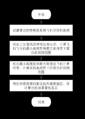
[0030] In this embodiment, the radar detection area is obtained through the input radar parameter information and the aircraft penetration height; figure 1 As shown, a fast calculation method for radar terrain shadowing blind area at multiple heights includes the following steps:

[0031] (1) Set the parameter information of the radar, input the longitude and latitude of the radar coordinate position, the height value of the radar, the scanning range of the radar and the point density when calculating the maximum detection range on the altitude layer, and the multiple penetration flight heights that need to be calculated put in order.

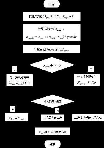
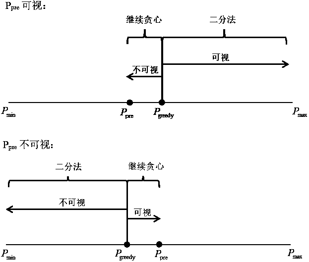
[0032] (2) Obtain elevation information based on digital elevation model data, and calculate the maximum detection range of the ra...


PUM


Abstract

The invention provides a rapid calculation method for a radar terrain shielding blind area under multiple heights. The method comprises the steps of setting parameter information of a radar, and sorting a plurality of defense penetration flight heights needing to be calculated; using a binary search method and an adjacent greedy method to calculate detection ranges of the radar under a minimum height layer and a maximum height layer of aircraft flight; taking the detection ranges of the radar under the minimum height layer and the maximum height layer as a minimum detection range and a maximumdetection range of a second minimum height layer, calculating the radar detection range of the second minimum height layer in the interval, and taking the calculation result as the minimum detectionrange in the next calculation; and calculating radar detection ranges of all heights, obtaining radar terrain shielding blind areas under multiple heights, and coloring and displaying calculated results. According to the method, the calculation amount can be effectively reduced, and the radar terrain shielding blind areas under the multiple heights can be quickly solved.

Description

technical field [0001] The invention relates to the field of calculation of radar blind areas, in particular to a fast calculation method for radar terrain shadowing blind areas at multiple heights. Background technique [0002] In modern warfare, when a fighter plane faces the enemy's detection radar for low-altitude and ultra-low-altitude penetration, it needs to pass through the radar threat space with the minimum risk of being detected. Due to the influence of factors such as terrain shading, earth curvature, and ground clutter interference, the detection radar will produce detection blind areas. Fighters often use radar blind areas in the process of penetrating defenses to avoid enemy detection. [0003] At present, when the altitude is known, the general algorithm for calculating the radar plane detection range is to use the radar position as the center of the circle, sequentially select points on the direction line from the initial position to the maximum operating di...

Claims


Application Information

Patent Timeline
Patent Type & Authority Applications(China)
IPC IPC(8): G01S7/40
CPCG01S7/40
Inventor 朱俊洁李辉沈凤黄操
Owner CHENGDU RONGAO TECH
Why Eureka
Try Eureka