Remote sensing image terrain classification method based on lightweight semantic segmentation network

A technology for remote sensing image and ground object classification, applied in the field of image processing, can solve the problems of ignoring advanced feature maps, more effective use of ground object category edge detailed processing, rough fusion method, and many network parameters, so as to reduce the amount of network parameters. , reduce the amount of calculation, reduce the effect of network structure

Active Publication Date: 2020-04-28
XIDIAN UNIV
View PDF3 Cites 32 Cited by
  • Summary
  • Abstract
  • Description
  • Claims
  • Application Information

AI Technical Summary

Problems solved by technology

This method makes full use of the characteristics of the encoder-decoder structure that can restore spatial features, and can better extract the features of various objects, but its fusion method of directly splicing high-level features and low-level features of the same size in the channel dimension is relatively rough. , ignoring the more effective use of advanced feature maps and the fine-grained processing of the edge of object categories. At the same time, there are many network parameters and time-consuming training, which restricts the improvement of the accuracy and speed of remote sensing image object classification tasks.

Method used


Image

  • Remote sensing image terrain classification method based on lightweight semantic segmentation network
  • Remote sensing image terrain classification method based on lightweight semantic segmentation network
  • Remote sensing image terrain classification method based on lightweight semantic segmentation network

Examples


Embodiment Construction

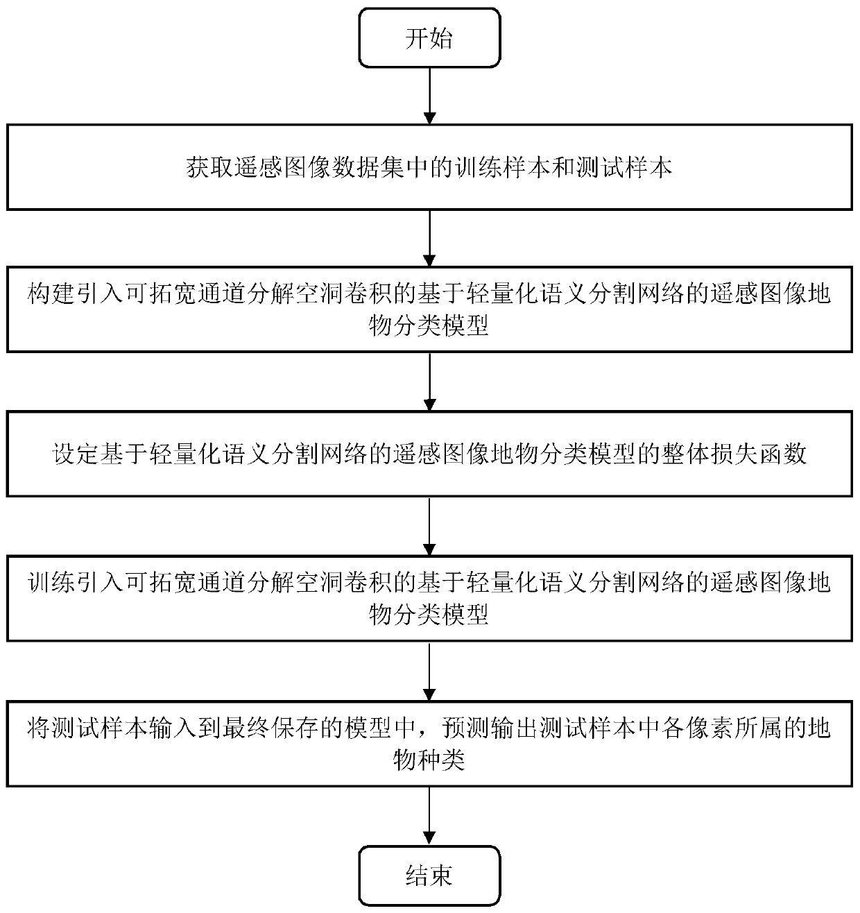
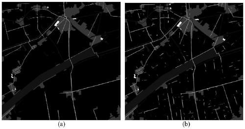
[0031] The embodiments and effects of the present invention will be further described below in conjunction with the accompanying drawings.

[0032] refer to figure 1 , the specific implementation steps of the present invention are as follows:

[0033] Step 1. Obtain the remote sensing image classification data set R and perform data preprocessing.

[0034] (1.1) Download the remote sensing image object classification data set R required for the experiment from the website;

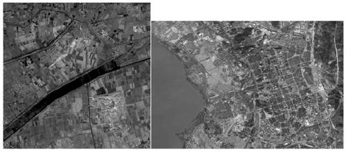
[0035] The remote sensing image ground object classification dataset contains the background class and other 4 different ground object categories including buildings, roads, water bodies, and vegetation. The data set has a total of 3 grayscale images, each with a size of about 2000×2000; and 12 color images with a size of 7400×4950.

[0036] (1.2) The above data are overlapped and cut into 512×512 size image blocks, the overlap size is 128, and the obtained image blocks are randomly divided into 80% tra...


PUM


Abstract

The invention discloses a remote sensing image terrain classification method based on a lightweight semantic segmentation network, and mainly solves the problems of low remote sensing image terrain classification precision and low training speed caused by insufficient utilization of image space and channel feature information and a huge model in an existing method. According to the scheme, the method includes obtaining a training sample and a test sample in a remote sensing image terrain classification data set; constructing and introducing a lightweight remote sensing image terrain classification model capable of broadening channel decomposition hole convolution, and designing an overall loss function of a concerned terrain edge; inputting a training sample into the constructed terrain classification model for training to obtain a trained model; and inputting the test sample into the trained model, and predicting and outputting a terrain classification result in the remote sensing image. According to the method of the invention, the feature expression capability is improved, the network parameters are reduced, the average precision and the training speed of remote sensing image terrain classification are improved, and the method can be used for obtaining the terrain distribution condition of a remote sensing image.

Description

technical field [0001] The invention belongs to the technical field of image processing, and in particular relates to a ground object classification method, which can be used in land use analysis, environmental protection and urban planning. Background technique [0002] The object classification of remote sensing images aims to replace tedious manual work, and use the method of object classification to obtain the classification result map of the input remote sensing image objects and background. Through the classification results of land objects, various applications such as land use analysis, environmental protection and urban planning can be carried out. [0003] The current classification methods can be roughly divided into two categories: [0004] The first category is based on traditional machine learning methods, usually using a two-layer structure consisting of feature extractors and classifiers. Feature extractors aim to extract spatial and texture features from l...

Claims


Application Information

Patent Timeline
Patent Type & Authority Applications(China)
IPC IPC(8): G06K9/00G06K9/62G06K9/44
CPCG06V20/13G06V10/34G06F18/241G06F18/253G06F18/214
Inventor 张向荣王昕焦李成李辰唐旭周挥宇陈璞花古晶
Owner XIDIAN UNIV
Why Eureka
Try Eureka