Planar intersection four-way green wave and regional coordination control and implementation method with four-way green wave effect

A two-way green wave and crossing technology, applied in the traffic control system of road vehicles, traffic control system, traffic signal control, etc.

Pending Publication Date: 2020-04-28
胡又宏
View PDF7 Cites 0 Cited by
  • Summary
  • Abstract
  • Description
  • Claims
  • Application Information

AI Technical Summary

Problems solved by technology

[0005] However, at an intersection, two two-way green waves intersect to form a four-way green wave, and then form a surface control with a four-way green wave effect. At present, there are no open literature and case reports. Even GB / T 31418-2015 " In Terminology of Road Traffic Signal Control System, there is no such entry as "four-way green wave"

Method used


Image

  • Planar intersection four-way green wave and regional coordination control and implementation method with four-way green wave effect
  • Planar intersection four-way green wave and regional coordination control and implementation method with four-way green wave effect
  • Planar intersection four-way green wave and regional coordination control and implementation method with four-way green wave effect

Examples


Embodiment approach 1

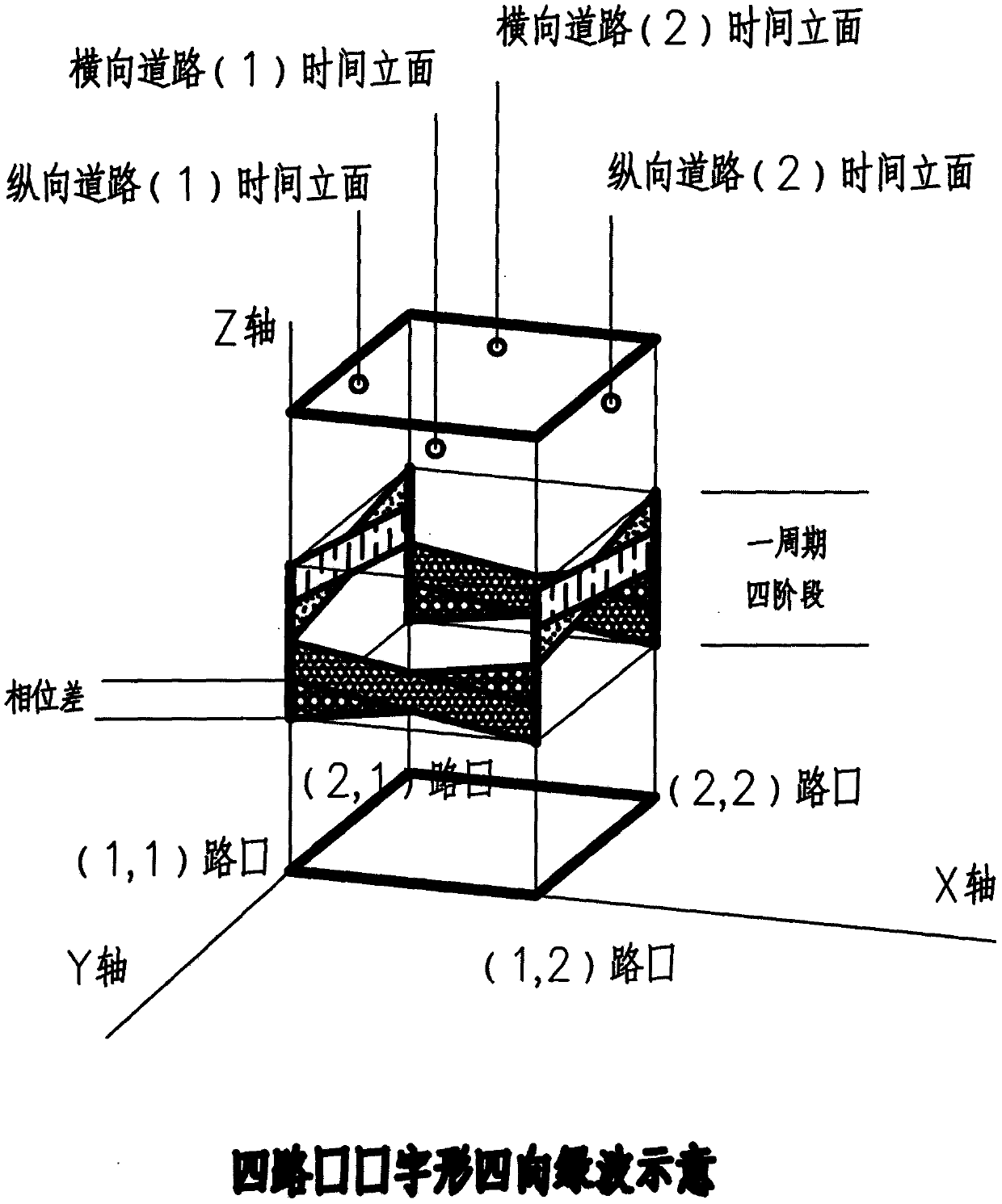
[0084] Based on the three-dimensional software, with the plane map as the bottom surface, the east-west road as the horizontal road (X-axis direction), the north-south road as the longitudinal road (Y-axis direction), and the Z-axis representing time is erected at each intersection position. Consistent time scale and road scale.

[0085] The intersections of the vertical and horizontal roads are respectively connected into lines (curves become equal-length broken lines), and the connecting lines are raised in parallel along the Z axis to form the time facades of the vertical and horizontal roads.

[0086] On the top of the vertical and horizontal road time elevations, draw the center line and lane line according to the width ratio of the road, and input the topological structure of the road network, the geometric data of intersections and road sections, the number and length of various guiding lanes at each entrance, Various information including the number of lanes at each ex...

Embodiment approach 1

[0102] A summary of the implementation:

[0103] Build volume models, conduct application scene investigations, draw road network maps, and draw time-distance maps of real-time traffic conditions.

[0104] Perform period, phase, phase sequence, and phase difference calculations from point to surface and / or from line to surface.

[0105] Generate a new four-way green wave time-distance map.

[0106] Generate the green wave service area on the road network map according to the time-distance map.

[0107] Simulate and demonstrate the four-way green wave service area, report relevant data and offline solutions.

[0108] Run the four-way green wave online, and push the service area information of the four-way green wave to the driving vehicles.

[0109] A new cycle of the above work is carried out according to the emerging situation.

Embodiment approach 2

[0111] Follow the core method of realizing the four-way green wave, perform calculations similar to the first embodiment, draw the time-distance map by road, but do not display the three-dimensional model.

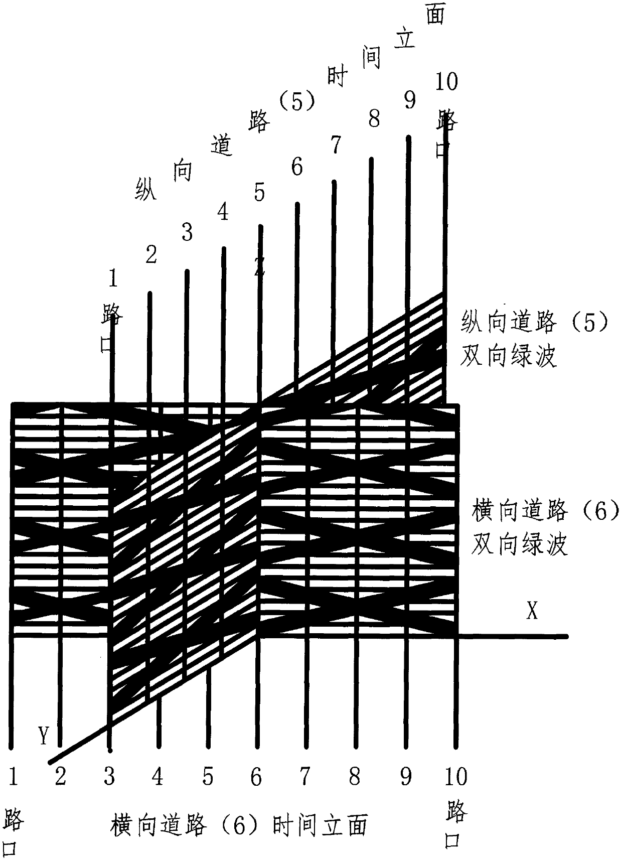
[0112] With the same time scale and road scale, draw the two-way green wave time-distance maps of the 4 vertical and 6 horizontal roads described in paragraph [0079], 10 in total.

[0113] Same as Embodiment 1, the factors that determine the period, phase, phase sequence, and phase difference include the flow, speed, headway, and distance between vehicles associated with time and space, the topological structure and geometric size of the road network, and the number of various guiding lanes. Quantity and length, quantity and timing of confluence arrival of upstream vehicles, various climate and weather conditions, etc.

[0114] Same as Embodiment 1, when drawing 10 vertical and horizontal two-way green wave time-distance maps, first unify the cycle, strictly abide by the g...


PUM


Abstract

A traffic signal control technology is adopted, and four-way green waves and surface control with a four-way green wave effect are implemented at a planar intersection of an urban road network. The design method is mainly a three-dimensional model method, a planar time-distance diagram method is a simplification of the method. The method further comprises other mathematical models, computer programs, animation trial and error backstepping and other methods which follow the thought of the three-dimensional model method and do not need to display a three-dimensional model and a planar time-distance diagram. All the methods conform to the principle that: a longitudinal road time vertical face and a transverse road time vertical face of each intersection intersect on a time axis and uplink anddownlink signal stages of the bidirectional green waves on the two vertical faces are made to coincide or intersect as much as possible on the time axis; if the uplink and downlink signal stages of the bidirectional green waves on the two vertical faces are away from each other, other phases can be inserted in the leaving time, and the release stage of the bidirectional green waves on the longitudinal vertical face and the release stage of the bidirectional green waves on the transverse vertical face are thoroughly separated. Therefore, a comprehensive or discrete four-way green wave model and method with the functions of design, verification, simulation display, data reporting, online operation and the like are established.

Description

technical field [0001] The invention belongs to the field of urban road traffic management, and relates to a method for improving traffic capacity of level intersections in an urban road network, in particular to an urban road traffic signal control technology. Background technique [0002] There are many ways to improve the traffic capacity of level intersections in urban road network. One is to expand the road space, realize the spatial separation of pedestrians, non-motor vehicles, and motor vehicles through the "channelization" of marking lines and isolation guardrails, and realize the separation of lanes for vehicles traveling in different directions; the other is to combine "space separation" "Develop urban road traffic signal control technology, and implement flexible "time separation" for traffic participants. [0003] In the urban road traffic signal control technology, the control of a level intersection (hereinafter referred to as intersection) is called point co...

Claims


Application Information

Patent Timeline
Patent Type & Authority Applications(China)
IPC IPC(8): G08G1/08G08G1/081
CPCG08G1/08G08G1/081
Inventor 胡又宏胡明皓张晶
Owner 胡又宏
Why Eureka
Try Eureka