Supercharge Your Innovation With Domain-Expert AI Agents!

Urban impervious surface remote sensing extraction method and system

An extraction method and extraction system technology, which is applied in the field of remote sensing extraction of impervious surfaces, can solve problems such as increased workload, low resolution of thermal infrared bands, interference with information extraction of impermeable surfaces, etc., and achieve the effect of improving extraction accuracy

Pending Publication Date: 2020-05-08
BEIJING NORMAL UNIVERSITY +1
View PDF0 Cites 0 Cited by
  • Summary
  • Abstract
  • Description
  • Claims
  • Application Information

AI Technical Summary

Problems solved by technology

In addition, indices such as NDISI need to use the thermal infrared band, and the resolution of the thermal infrared band is relatively low. Although it plays a certain role in fusion and refinement in the mixed calculation with multi-spectral bands, it still exacerbates the phenomenon of mixed pixels. , many remote sensing images do not exist in the thermal infrared band, especially high-resolution images
In addition, the MNDISI index incorporates the less common high-resolution nighttime light index, limiting the usefulness of the index
[0004] A city is a complex composed of various land cover types such as impervious surfaces, vegetation, water bodies, and bare soils. The spectral characteristics of bare soils are very close to those of impervious surfaces, which often interferes with the extraction of information on impervious surfaces; in addition, many The methods for extracting impervious surface information are all based on Ridd's VIS model, which regards the city as a linear combination of vegetation, impervious surface and soil, and does not consider water bodies. Therefore, these methods need to extract impervious surfaces before extracting them. Masking out the water body information in advance not only increases the workload, but also easily produces errors in the process of water body extraction; in addition, some indices such as NDISI and MNDISI need to use the thermal infrared band, which intensifies the phenomenon of mixed pixels and reduces the Extraction accuracy of permeable surface information

Method used


Image

  • Urban impervious surface remote sensing extraction method and system
  • Urban impervious surface remote sensing extraction method and system
  • Urban impervious surface remote sensing extraction method and system

Examples


Embodiment Construction

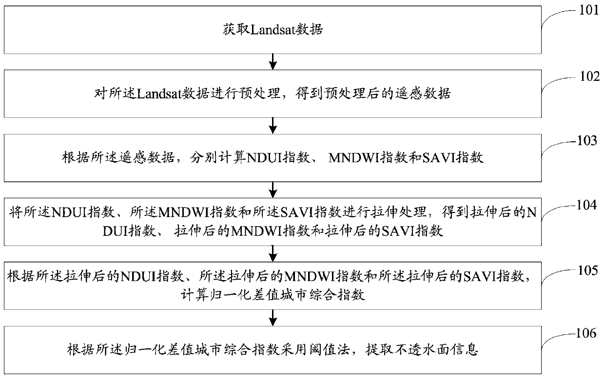
[0053] The following will clearly and completely describe the technical solutions in the embodiments of the present invention with reference to the accompanying drawings in the embodiments of the present invention. Obviously, the described embodiments are only some, not all, embodiments of the present invention. Based on the embodiments of the present invention, all other embodiments obtained by persons of ordinary skill in the art without making creative efforts belong to the protection scope of the present invention.

[0054] The purpose of the present invention is to provide a remote sensing extraction method and system for urban impermeable surfaces, which can improve the extraction accuracy of impermeable surfaces.

[0055] In order to make the above objects, features and advantages of the present invention more comprehensible, the present invention will be further described in detail below in conjunction with the accompanying drawings and specific embodiments.

[0056] T...


PUM


Abstract

The invention relates to an urban impervious surface remote sensing extraction method and system. The method comprises the following steps: acquiring Landsat data; preprocessing the Landsat data to obtain preprocessed remote sensing data; according to the remote sensing data, respectively calculating an NDUI index, an MNDWI index and an SAVI index; stretching the NDUI index, the MNDWI index and the SAVI index to obtain a stretched NDUI index, a stretched MNDWI index and a stretched SAVI index; calculating a normalized difference city comprehensive index according to the stretched NDUI index, the stretched MNDWI index and the stretched SAVI index; and extracting impervious surface information by adopting a threshold method according to the normalized difference city comprehensive index. Themethod can improve the extraction precision of the impermeable surface.

Description

technical field [0001] The invention relates to the field of remote sensing extraction of impervious surfaces, in particular to a remote sensing extraction method and system for urban impermeable surfaces. Background technique [0002] The traditional method of obtaining impervious surface information is mainly manual surveying and mapping, but this method is time-consuming, laborious, expensive, and has poor real-time performance. With the rapid development of satellite remote sensing technology, its advantages such as fast speed, large range and multi-scale have solved the shortcomings of traditional methods. More and more remote sensing inversion methods for impervious surface information have been proposed. At present, the research methods are mainly divided into The following 5 types: classification method, spectral mixture analysis method, regression model method, decision tree model method and spectral-based index method. At present, the classification methods for im...

Claims


Application Information

Patent Timeline
IPC IPC(8): G01N21/17
CPCG01N21/17G01N2021/1793G01N21/31G01N21/359G01N21/55G01N2021/1797G01N2021/3155G01N2021/8466
Inventor 陈艳玲宫阿都陈云浩雷添杰曾婷婷杨雨晴
Owner BEIJING NORMAL UNIVERSITY
Features
  • R&D
  • Intellectual Property
  • Life Sciences
  • Materials
  • Tech Scout
  • Unparalleled Data Quality
  • Higher Quality Content
  • 60% Fewer Hallucinations
Learn More