High-precision map making system and method based on road test equipment

A technology of road test equipment and production method, which is applied to the traffic control system of road vehicles, traffic control systems, instruments, etc., can solve the problems of low efficiency, small feasibility, large storage space of high-precision maps, etc., to save manpower and Material resources, expanding distribution range, and expanding the effect of transmission range

Active Publication Date: 2020-05-19
TONGJI UNIV
View PDF4 Cites 4 Cited by
  • Summary
  • Abstract
  • Description
  • Claims
  • Application Information

AI Technical Summary

Problems solved by technology

[0003] Due to the relatively small amount of information, general navigation maps can be stored offline on the car and provide navigation services to drivers. However, the richness of information described by high-precision maps determines that high-precision maps need to occupy a relatively large storage space. At the same time, due to intelligent driving The capacity of the storage device for storing high-precision maps on the car is limited, and the high-precision maps covering a large area cannot be fully stored in ordinary smart driving cars, which will directly affect the driving range of smart driving vehicles
[0004] In the current high-precision map production process, a large number of data collection vehicles need to be used to collect data, which consumes a lot of bandwidth and generates a long delay, but this data collection method is inefficient. In actual application scenarios, this dynamic update method is less feasible

Method used


Image

  • High-precision map making system and method based on road test equipment
  • High-precision map making system and method based on road test equipment
  • High-precision map making system and method based on road test equipment

Examples


Embodiment 1

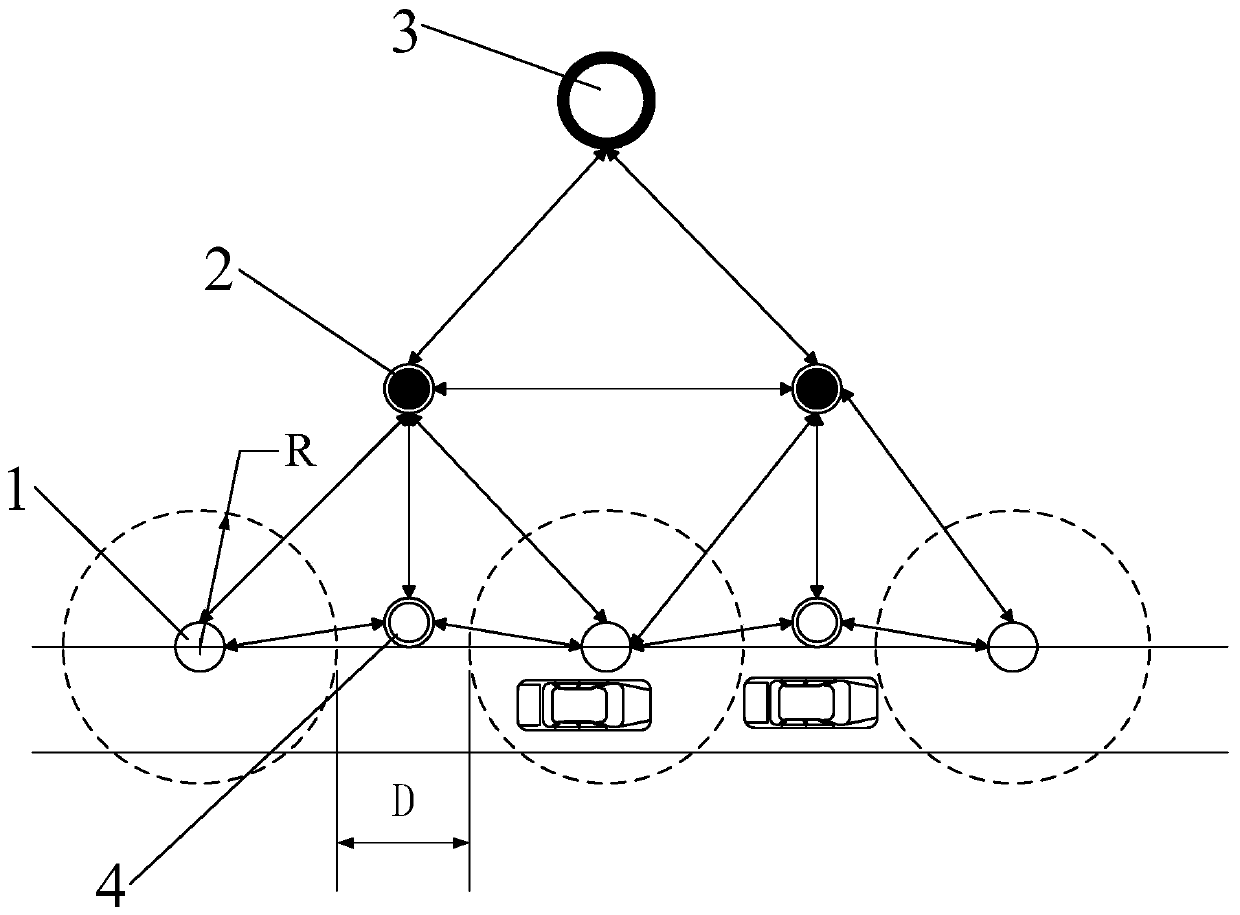
[0040] A high-precision map production system based on drive test equipment, such as figure 1 ,include:

[0041] The roadside module includes a plurality of roadside units 1 for collecting road information;

[0042] The central node 2 is used to summarize the road information collected by the roadside module;

[0043] The cloud server 3 is used to receive the road information summarized by the central node, and complete the construction and update of the high-precision map;

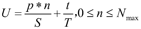
[0044] The number of central nodes is multiple, and each central node is wirelessly connected to at least one other central node, and n is set at equal intervals along the road direction per kilometer min Roadside units, where n min Obtained by establishing a deployment cost assessment model, the calculation formula of which is:

[0045]

[0046] Where U is the cost evaluation value, p is the cost of a single roadside unit, n is the number of roadside units per kilometer of road section, S is the b...

Embodiment 2

[0057] A high-precision map production method based on road test equipment, specifically: roadside equipment is deployed on the road, and road information is transmitted to the server through the roadside equipment and the central node in sequence, so as to realize the construction and update of the overall high-precision map, each Roadside equipment includes sensors, GPS, GPRS and V2R, and sensors include lidar, millimeter wave radar and cameras.

[0058] The number of central nodes is multiple, and each central node is wirelessly connected to at least one other central node, and n is set at equal intervals along the road direction per kilometer min roadside equipment, where n min Obtained by establishing a deployment cost assessment model, the calculation formula of which is:

[0059]

[0060] Where U is the cost evaluation value, p is the cost of a single roadside equipment, n is the number of roadside equipment per kilometer of road section, S is the budgeted cost per ...


PUM


Abstract

The invention relates to a high-precision map making system and method based on road test equipment. The system comprises a road side module which comprises a plurality of road side units and is usedfor collecting road information; central nodes which are used for summarizing the road information acquired by the road side module; and a cloud server which is used for receiving the road informationgathered by the central node and completing construction and updating of a high-precision map, wherein there are multiple central nodes, each central node is wirelessly connected with at least one other central node, the cloud server is wirelessly connected with at least one central node, nmin road side units are arranged at equal intervals along the road direction per kilometer, and nmin is obtained by establishing a deployment cost evaluation model. Compared with the systems and the methods in the prior art, the system and the method have the advantages of low cost, high effectiveness, fault tolerance and the like.

Description

technical field [0001] The invention relates to automatic driving technology, in particular to a high-precision map production system and method based on road test equipment. Background technique [0002] At present, unmanned driving technology has gradually entered people's lives. Unmanned driving is driven by cars. Among them, high-precision maps are a necessary technology for large-scale deployment of unmanned vehicles. High-precision maps contain rich road traffic information elements. Including high-precision geographic location coordinates, road shape and number of lanes, etc., to provide a reliable guarantee for related positioning technologies. [0003] Due to the relatively small amount of information, general navigation maps can be stored offline on the car and provide navigation services to drivers. However, the richness of information described by high-precision maps determines that high-precision maps need to occupy a relatively large storage space. At the same ...

Claims


Application Information

Patent Timeline
Patent Type & Authority Applications(China)
IPC IPC(8): G08G1/0968G08G1/0969
CPCG08G1/0968G08G1/0969
Inventor 肖骁胡笳
Owner TONGJI UNIV
Why Eureka
Try Eureka