A method and application of designating a collision risk zone in a flight segment

A collision risk and flight segment technology, applied in the field of UAV air traffic operation management, can solve the problems of loss of risk assessment accuracy and the inability to guarantee the rationality of collision risk zoning.

Active Publication Date: 2021-02-23
THE SECOND RES INST OF CIVIL AVIATION ADMINISTRATION OF CHINA
View PDF3 Cites 0 Cited by
  • Summary
  • Abstract
  • Description
  • Claims
  • Application Information

AI Technical Summary

Problems solved by technology

In addition, a large number of studies assume that the flight error of the aircraft satisfies a fixed distribution within a flight segment, but it facilitates the calculation of the collision risk assessment and at the same time has a certain loss in the accuracy of the risk assessment, and thus cannot guarantee the rationality of the designation of the collision risk area

Method used


Image

  • A method and application of designating a collision risk zone in a flight segment
  • A method and application of designating a collision risk zone in a flight segment
  • A method and application of designating a collision risk zone in a flight segment

Examples


Embodiment example

[0098] Implementation case: Collision risk zone designation under the approach procedure of an airport

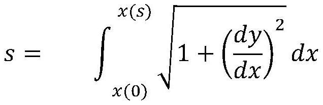
[0099] Flight on final approach segment is a straight line. This example gives an example of the instrument approach procedure of Chongqing Jiangbei Airport RWY02R. According to the information on the instrument approach chart, s 0 = 10000 meters, horizontal velocity v x = 93.05 m / s, v y = 0 m / s, v z =4.9 m / s, so it can be seen that the descent gradient of the aircraft during the approach phase is old flight segment To meet the conditions:

[0100] x(s)=s

[0101] y(s)=0

[0102] z(s)=k×s

[0103] Assume that the lateral error and vertical error of the flight satisfy a normal distribution with a mean of zero, namely:

[0104] ε y (s)~N[0,δ 0 (s)]

[0105] ε z (s)~N[0,δ 1 (s)]

[0106] Assuming the standard deviation satisfies:

[0107]

[0108]

[0109] where b 0 =0.02,b 1 =0.01, take the size of the aircraft as: λ y =50,λ z = 15, for the targ...


PUM


Abstract

The present invention provides a method for delineating a collision risk area for a flight segment, including step S1, describing the geometric characteristics of the segment according to the characteristics of the segment data; step S2, establishing the boundary of the collision risk area according to the segment curve and the collision risk probability e model; step S3 defines the collision risk area as the minimum area where the boundary satisfies the constraint condition; step S4 calculates the parameters corresponding to the risk boundary. The planning method provided by the invention provides guarantee for the safety and efficiency of the operation of civil aircraft in the ultra-low airspace around the airport, and provides technical support for realizing the refined operation management of the unmanned aerial vehicle.

Description

technical field [0001] The invention relates to the technical field of air traffic control, in particular to unmanned aerial vehicle air traffic operation management. Background technique [0002] In recent years, the scale of the civilian UAV market has continued to expand. UAVs are easy to manufacture and easy to obtain, making UAVs widely used. This has also accompanied the emergence of various risks hidden in the operation of UAVs, among which the most typical The biggest risk is that drone flights interfere with the normal take-off and landing of flights at civil aviation airports. In July 2014, a civil airliner that was preparing to land at Heathrow Airport in London almost collided with a black flying drone. The accident investigation was determined by the authorities as a "serious risk of collision" with a grade of "A"; in 2016 In April, a civil airliner carrying 132 passengers and 5 crew members collided with a remote-controlled drone on the way from Geneva to Lond...

Claims


Application Information

Patent Timeline
Patent Type & Authority Patents(China)
IPC IPC(8): G06F30/20G06F17/18
CPCG06F17/18
Inventor 张建平谢方泉吴卿刚邹翔陈振玲
Owner THE SECOND RES INST OF CIVIL AVIATION ADMINISTRATION OF CHINA
Why Eureka
Try Eureka