On-site mapping system for engineering mapping

An on-site and engineering technology, applied in the field of on-site surveying and mapping systems for engineering surveying and mapping, can solve problems such as inconvenient operation, inaccuracy, and inconvenient adjustment, and achieve the effects of prolonging service life, good protection, and improving stability

Pending Publication Date: 2020-05-29
浙江中信检测有限公司
View PDF0 Cites 11 Cited by
  • Summary
  • Abstract
  • Description
  • Claims
  • Application Information

AI Technical Summary

Problems solved by technology

[0004] The purpose of the present invention is to solve the inconvenience of adjustment existing in the prior art, it is difficult to accurately measure for the construction site surveying and mapping, the operation is complicated and not accurate enough, the rare precision instrument is too large to move, or the field is complicated and inconvenient to operate, Or it is impossible to make timely and effective adjustments according to terrain factors, and the proposed on-site surveying and mapping system for engineering surveying and mapping

Method used


Image

  • On-site mapping system for engineering mapping
  • On-site mapping system for engineering mapping
  • On-site mapping system for engineering mapping

Examples


Embodiment 1

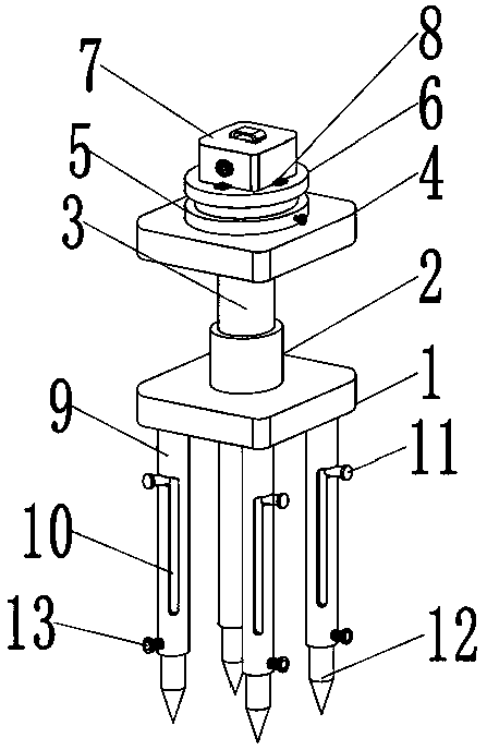
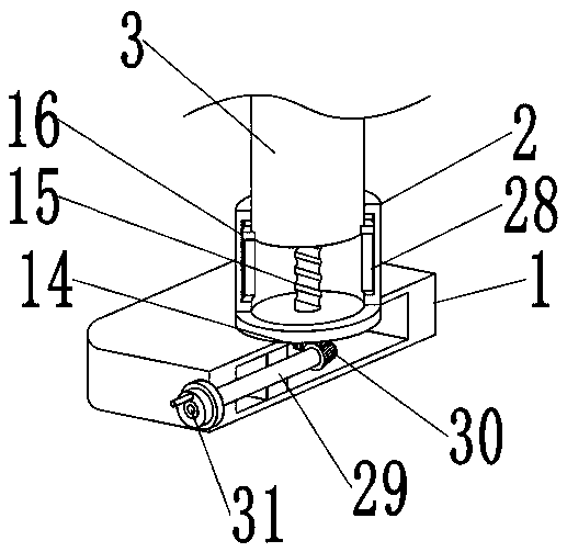
[0038] The on-site surveying and mapping system for engineering surveying and mapping, the on-site surveying and mapping system for engineering surveying and mapping, includes a pedestal 1, a column 2 is welded to the axis of the outer wall of the top of the pedestal 1, and the top of the column 2 is movably connected to a lifting rod 3, and the top of the lifting rod 3 The top plate 4 is welded, the end of the lifting rod 3 located inside the column 2 is threadedly connected with a lead screw 15, and the end of the lead screw 15 located inside the pedestal 1 is welded with a driven bevel gear 14, and the center of the front outer wall of the pedestal 1 passes through the bearing Be movably connected with transmission rod 29, and transmission rod 29 is welded with driving bevel gear 30 intermeshing with driven bevel gear 14 near one end of driven bevel gear 14, and transmission rod 29 is away from the other end of driving bevel gear. The key is connected with a handwheel 31, an...


PUM


Abstract

The invention discloses an on-site mapping system for engineering mapping. The on-site mapping system comprises a pedestal, a cylinder is welded to the axis of the outer wall of the top of the pedestal, and the top end of the cylinder is movably connected with a lifting rod; a top plate is welded to the top end of the lifting rod, the end, in the cylinder, of the lifting rod is in threaded connection with a lead screw, and a driven conical gear is welded to the end, in the pedestal, of the lead screw; and the center of the outer wall of the forward face of the pedestal is movably connected with a transmission rod through a bearing, and a driving conical gear engaged with the driven conical gear is welded to the end, close to the driven conical gear, of the transmission rod. The height of amapper main body can be adjusted through the lifting rod, thus the height of the on-site mapping system is suitable for the height of a user for on-site mapping and measurement, the mapper main bodycan adjust the height of supporting feet according to different terrains, thus the measurement stability of the mapper main body is greatly improved, building engineering construction cost on-site mapping is optimized, and thus mapping becomes easier and more accurate.

Description

technical field [0001] The invention relates to the technical field of engineering surveying and mapping, in particular to an on-site surveying and mapping system for engineering surveying and mapping. Background technique [0002] Surveying and mapping is based on computer technology, photoelectric technology, network communication technology, space science, and information science, with the global positioning system (GPS), remote sensing (RS), and geographic information system (GIS) as the technical core. Points and boundaries obtain graphics and position information reflecting the current status of the ground through measurement means, which are used for planning, design and administrative management of engineering construction. [0003] Traditional surveying and mapping devices are inconvenient to adjust, and it is difficult to accurately measure for construction site surveying and mapping. adjustment. Therefore, it is urgent to design an on-site surveying and mapping ...

Claims


Application Information

Patent Timeline
Patent Type & Authority Applications(China)
IPC IPC(8): F16M11/04F16M11/08F16M11/18F16M11/32G01C15/00
CPCF16M11/046F16M11/08F16M11/18F16M11/32G01C15/00
Inventor 肖乐春沈军叶慧丽
Owner 浙江中信检测有限公司
Why Eureka
Try Eureka