Control system and method for cooperative surveying and mapping of unmanned ship and unmanned aerial vehicle

A technology of control system and unmanned boat, which is applied in control/adjustment system, radio wave measurement system, two-dimensional position/channel control, etc. It can solve the problem of short operation time, poor endurance of drones, and difficulty in obtaining surveying and mapping results and other issues to achieve the effects of saving time, improving the efficiency of land surveying and mapping, and improving the overall battery life

Inactive Publication Date: 2020-05-29
SHANGHAI UNIV
View PDF7 Cites 8 Cited by
  • Summary
  • Abstract
  • Description
  • Claims
  • Application Information

AI Technical Summary

Problems solved by technology

[0002] In terms of automatic surveying and mapping of target sea areas with shoal islands and reefs, the existing unmanned boats can survey and map the seabed with a certain depth in the target sea area. Because some islands and reefs protrude from the water, or form some islands and reefs, it is impossible to realize Complete surveying and mapping of island and reef waters
Unmanned aerial vehicles can realize the surveying and mapping of the terrain above the islands and reefs, but the surveying and mapping of the seabed topographic map cannot be obtained. At the same time, when using a single drone for surveying and mapping, because the survey ship is far away from the target sea area, the endurance of the drone is poor and the operation time is short. Difficult to obtain good surveying and mapping results

Method used


Image

  • Control system and method for cooperative surveying and mapping of unmanned ship and unmanned aerial vehicle
  • Control system and method for cooperative surveying and mapping of unmanned ship and unmanned aerial vehicle

Examples


Embodiment

[0035] The control method realized by the above-mentioned control system for unmanned boat and unmanned aerial vehicle cooperative surveying and mapping specifically includes the following steps:

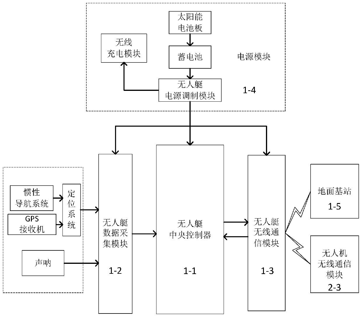
[0036] i. The unmanned boat carrying the drone arrives at the shoal of the target sea area to navigate around islands and reefs according to the surveying and mapping sonar system. During the navigation, it avoids obstacles according to the set navigation warning value. Record the time, latitude and longitude at this time every 10 seconds and record to store;

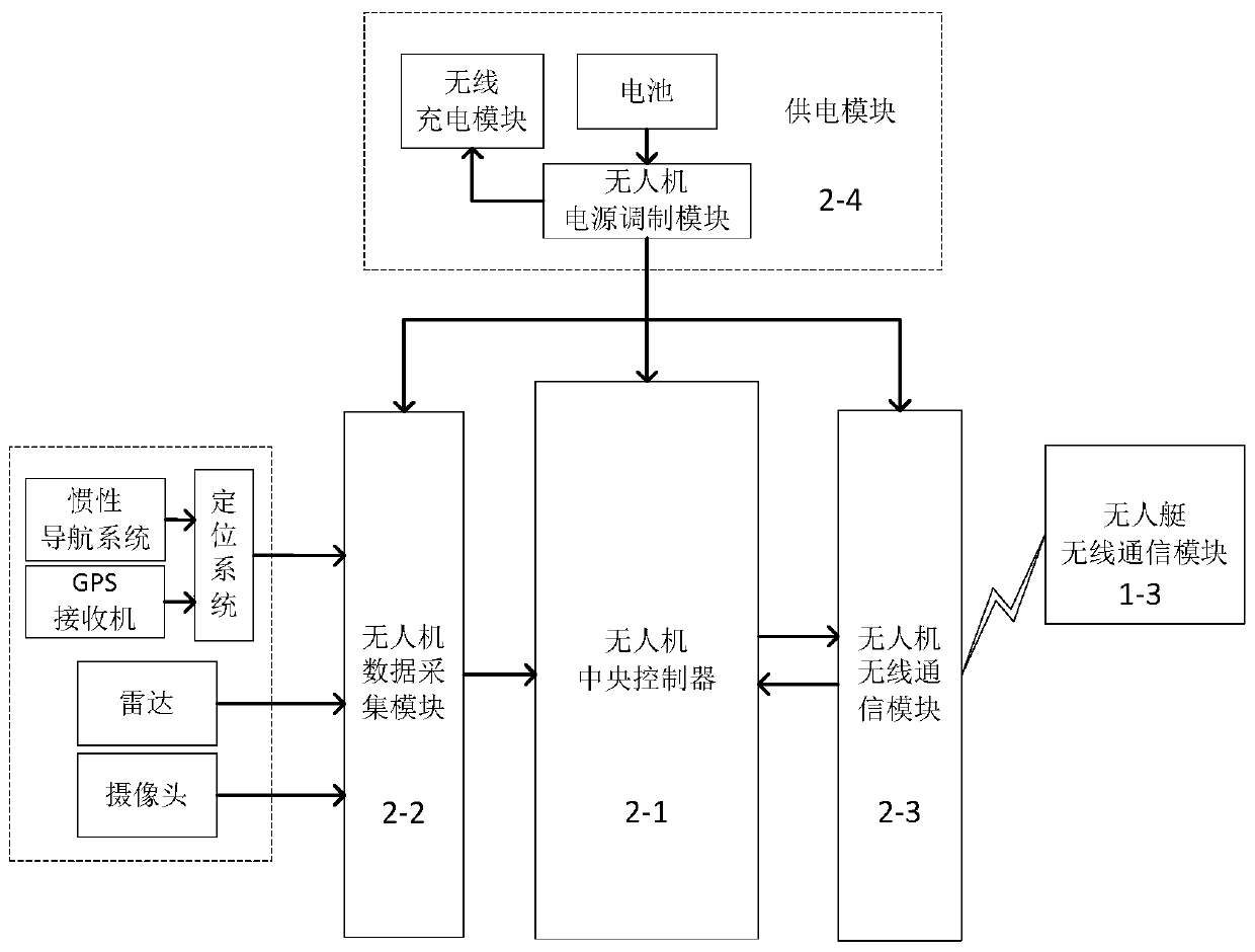
[0037] ii. After the unmanned boat circles the target island and reef for a week, it stops sailing, connects the latitude and longitude points in turn according to the recorded time to form an electronic fence, and sends all the data to the drone through the unmanned boat wireless communication module 1-3;

[0038] iii. After the UAV receives all the signals, it sends a successful reception message to the unmanned boat, infor...


PUM


Abstract

The invention discloses a control system and a control method for the cooperative surveying and mapping of an unmanned ship and an unmanned aerial vehicle. The control system comprises an unmanned ship cooperative surveying and mapping device in the unmanned ship and an unmanned aerial vehicle cooperative surveying and mapping device in the unmanned aerial vehicle which performs mutual communication cooperative surveying and mapping. The automatic surveying and mapping of shoal sea areas with many islands and reefs are realized; the surveying and mapping task of a sea area which cannot be reached by a large surveying and mapping ship can be completed with high efficiency and low cost, meanwhile, the submarine topography can be surveyed and mapped, the surveying and mapping of an upper portion of an island reef can be achieved, and the surveying and mapping task of a target sea area is achieved more completely. The invention belongs to the technical field of unmanned ship and unmanned aerial vehicle cooperative application.

Description

technical field [0001] The invention belongs to the technical field of collaborative application of unmanned boats and unmanned aerial vehicles, and relates to the technical field of control technology for unmanned boats and unmanned aerial vehicles to coordinate the surveying and mapping of islands and reefs. Surveying and mapping control system and its control method. Background technique [0002] In terms of automatic surveying and mapping of target sea areas with shoal islands and reefs, the existing unmanned boats can survey and map the seabed with a certain depth in the target sea area. Because some islands and reefs protrude from the water, or form some islands and reefs, it is impossible to realize Complete mapping of reef waters. Unmanned aerial vehicles can realize the surveying and mapping of the terrain above the islands and reefs, but the surveying and mapping of the seabed topographic map cannot be obtained. At the same time, when using a single drone for surv...

Claims


Application Information

Patent Timeline
Patent Type & Authority Applications(China)
IPC IPC(8): G05D1/02G05D1/10G01S15/89G01S13/88H04N7/18
CPCG01S13/88G01S15/89G05D1/0206G05D1/101H04N7/18
Inventor 钟雨轩成敏彭艳王曰英张丹罗均谢少荣蒲华燕
Owner SHANGHAI UNIV
Why Eureka
Try Eureka