Roadside illegal building identification method of road aerial image

A technology of illegal buildings and aerial pictures, which is applied in the field of identification of roadside illegal buildings in road aerial images, can solve problems such as hindering urban development and construction, failure to detect in time, and lower efficiency, and achieve strong adaptability, good stability, and detection accurate effect

Pending Publication Date: 2020-05-29
上海翼枭航空科技有限公司
View PDF4 Cites 6 Cited by
  • Summary
  • Abstract
  • Description
  • Claims
  • Application Information

AI Technical Summary

Problems solved by technology

[0003] The traditional monitoring and management of illegal buildings on both sides of the road mainly depends on the discovery and confirmation of reports from the masses. Illegal buildings have been banned repeatedly and cannot be discovered in time, thus hindering the development and construction of the city
[0004] At present, there are still some methods to identify roadside illegal buildings through the analysis of road images, but the existing identification methods are to compare the collected pictures with the original historical pictures one by one. This identification method needs to be called repeatedly. Historical pictures, and most of them need to be identified and detected by manpower, which consumes resources and reduces efficiency

Method used


Image

  • Roadside illegal building identification method of road aerial image

Examples


Embodiment Construction

[0015] The embodiments of the present invention are described in further detail below in conjunction with the accompanying drawings, but the present embodiments are not intended to limit the present invention. All similar structures and similar changes of the present invention should be included in the scope of protection of the present invention. The commas in all represent the relationship between and, and the English letters in the present invention are case-sensitive.

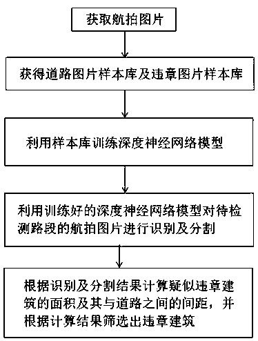
[0016] Such as figure 1 As shown, a method for identifying roadside illegal buildings in road aerial images provided by an embodiment of the present invention is characterized in that the specific steps are as follows:

[0017] S1: Use aerial photography to obtain aerial pictures of each section of the target road, and obtain a sample library of pictures of the target road. The target road for aerial photography is preferably sunny and cloudy, and rainy weather should be avoided as much as possible;

[001...


PUM


Abstract

The invention discloses a roadside illegal building identification method of a road aerial image, relates to the technical field of road administration facilities, and solves the technical problem ofimproving the identification efficiency. The method comprises the following steps: constructing a road picture sample library and a peccancy picture sample library of suspected peccancy buildings by utilizing aerial pictures of each road section of a target road; and training a deep neural network model by using the constructed sample library, and identifying and segmenting aerial pictures of a to-be-detected road section of the target road by using the trained deep neural network model to identify illegal buildings from the aerial pictures. The identification method provided by the inventionis used for identifying illegal buildings on two sides of a road, and can improve the illegal building identification efficiency.

Description

technical field [0001] The invention relates to road administration facility technology, in particular to a method for identifying roadside illegal buildings in road aerial images. Background technique [0002] The road chief system is a kind of urban management model, which effectively promotes the transformation of urban management to refinement according to the principles of one road, one long road, combination of sections, and territorial management. Buildings, it is necessary to identify the illegal buildings on both sides of the road and determine their approximate locations, so that the inspectors can confirm and monitor them on the spot. [0003] The traditional monitoring and management of illegal buildings on both sides of the road mainly depends on the discovery and confirmation of reports from the masses. Illegal buildings have been banned repeatedly and cannot be found in time, thus hindering the development and construction of the city. [0004] At present, th...

Claims


Application Information

Patent Timeline
Patent Type & Authority Applications(China)
IPC IPC(8): G06K9/00G06N3/04G06N3/08
CPCG06N3/08G06V20/176G06N3/045
Inventor 钱雷
Owner 上海翼枭航空科技有限公司
Why Eureka
Try Eureka