A laser radar data processing method

A data processing and lidar technology, applied in the field of data processing, can solve the problems that the calculation time and calculation time cannot be effectively improved, affect the normal driving of vehicles, and the offline grid map cannot effectively reduce redundant point cloud data. Achieve the effects of improving implementation efficiency, reducing calculation amount, and shortening calculation time

Active Publication Date: 2021-10-01
许昌泛网信通科技有限公司
View PDF8 Cites 0 Cited by
  • Summary
  • Abstract
  • Description
  • Claims
  • Application Information

AI Technical Summary

Problems solved by technology

[0004] In view of the deficiencies in the existing technology, the purpose of the present invention is to provide a laser radar data processing method, which effectively solves the problem that the offline grid map cannot effectively reduce redundant point cloud data, so that the calculation time and calculation duration cannot be effectively obtained. Improvement, which in turn affects the normal driving of the vehicle

Method used


Image

  • A laser radar data processing method
  • A laser radar data processing method
  • A laser radar data processing method

Examples


Embodiment Construction

[0025] For the aforementioned and other technical content, characteristics and efficacy of the present invention, with reference to reference Figure 1-12 In the detailed description of the embodiments, it will be clearly presented. The structural content mentioned in the following examples is referenced in the accompanying drawings.

[0026] Each of the exemplary embodiments of the present invention will be described below with reference to the drawings.

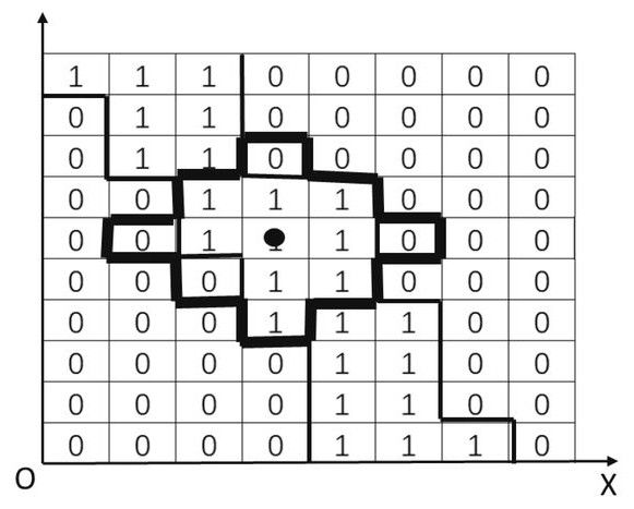
[0027] A laser radar data processing method, applied to the processor contained in the vehicle, first according to the vehicle travel area according to the vehicle position information, the vehicle processor makes the vehicle travel area as offline grid, laser radar The surrounding environment is converted into point cloud data, using the data processing method to block the point cloud data, then "the point cloud data and offline grid maps after the block processing" and "reduces the redundancy of point cloud data, Improve the e...


PUM


Abstract

The invention discloses a laser radar data processing method, which effectively solves the problem that offline grid maps cannot effectively reduce redundant point cloud data, and the extraction rate of effective areas is not high, so that the calculation time and calculation duration cannot be effectively improved. And then affect the normal running of the vehicle. In the present invention, after determining the driving area of ​​the vehicle according to the vehicle position information, the on-board processor makes the driving area of ​​the vehicle into an offline grid map, the laser radar converts the surrounding environment of the vehicle into point cloud data, and uses the data processing method to first analyze the point cloud data. Block processing, and then perform "AND" operation with the offline grid map, which can filter redundant point cloud data in multiple driving scenes of the vehicle, reduce the calculation amount of point cloud data, shorten the calculation time, and improve the The implementation efficiency of point cloud data improves the extraction rate of the effective area and reduces the impact of redundant point cloud data on the normal driving of the vehicle.

Description

Technical field [0001] The present invention relates to the field of data processing, particularly a laser radar data processing method. Background technique [0002] Tens of thousands of dot cloud data generated during laser radar detection environments, only 16-wire mechanical laser radar is about 300,000 per second, including all obstacle information around 360 ° around the radar, due to laser radar The converted point cloud data has redundancy and sparsiness, and it is necessary to filter out the point cloud data of the unrelated area, and the effective area is convenient to subsequent processing. The prior art uses an offline grid map and "performs" and "the laser radar scan range rasterization to filter out the point cloud data of the independent area, but the label of the grid within the scanning range of the laser radar is 1 However, 10 cm * 10cm offline grid map has reduced some of the calculated amounts during the driving process, but the range of "and" operation is req...

Claims


Application Information

Patent Timeline
Patent Type & Authority Patents(China)
IPC IPC(8): G01S7/48G01S7/487G01S7/493G01S17/88G01S17/931
CPCG01S7/4802G01S7/4876G01S7/493G01S17/88G01S17/933
Inventor 路兆铭王鲁晗邵华曹伟豪赵百泉程杨
Owner 许昌泛网信通科技有限公司
Why Eureka
Try Eureka