Point-based iterative remote sensing image road extraction method

A technology for remote sensing image and road extraction, applied in the field of computer vision, can solve the problem of difficulty in combining graph-level connectivity and pixel-level accuracy at the same time, and achieve the effect of good road and intersection alignment

Pending Publication Date: 2020-06-09
NANKAI UNIV
View PDF8 Cites 10 Cited by
  • Summary
  • Abstract
  • Description
  • Claims
  • Application Information

AI Technical Summary

Problems solved by technology

[0008] The purpose of the present invention is to solve the problem that the existing methods are difficult to achieve both graph-level connectivity and pixel-level accuracy, and propose an iterative road that uses road segmentation as a guide, supplemented by dynamic step size and trajectory exploration Graph Exploration Methods

Method used


Image

  • Point-based iterative remote sensing image road extraction method
  • Point-based iterative remote sensing image road extraction method
  • Point-based iterative remote sensing image road extraction method

Examples


Embodiment Construction

[0022] The present invention will be further described in detail below in conjunction with the accompanying drawings and specific embodiments.

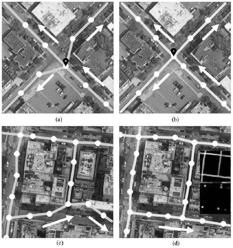
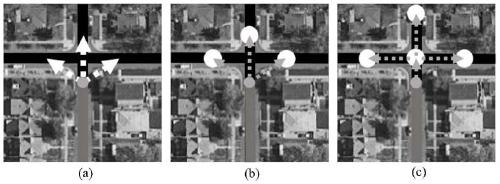
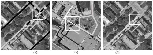
[0023] The iterative exploration framework iteratively constructs a road map by continuously predicting the next action and merging its predictions into the existing road map. The present invention adopts this framework and proposes several schemes to improve the performance of the constructed roadmaps. First, a point-based next-step movement representation is utilized, which is a joint representation of movement angle and distance, so that multiple constraints can be applied during the training phase without multiple supervisions. Second, this paper proposes a variable-step detection technique, which benefits from a point-based representation and can be achieved by simply changing the position of the drop point in the supervision information, which aims to dynamically align the training phase with the road. This paper also utilizes ...


PUM


Abstract

The invention discloses a point-based iterative remote sensing image road extraction method. Compared with on-site collection, automatic extraction of the road centerline map from the remote sensing image is higher in efficiency and lower in cost. In order to improve road connectivity and keep accurate alignment between a road map and a real road center line, the invention provides a point-based iterative road map exploration method using segmentation clue guidance, variable step length and trajectory exploration. Wherein the segmentation clues are embodied as follows: center line segmentationand intersection point segmentation are used as supervision information in the neural network; wherein the variable step length is embodied in that an adjustable step length training neural network is used at a road intersection point, a road end point and a connection point, and the trajectory exploration method is embodied in that a next drop point set starting from an image center point according to a time sequence is obtained by utilizing one-time remote sensing image input.

Description

technical field [0001] The invention belongs to the technical field of computer vision, and in particular relates to a method and application for extracting roads from remote sensing images by using a neural network. Background technique [0002] Extracting roads from remote sensing images is a research topic in the field of remote sensing. Traditional approaches construct road maps through various techniques, such as utilizing prior knowledge of nearby buildings and vehicles (hinz et al.) [ISPRS journal of photogrammetry and remote sensing, 2003, 58(1-2):83-98], shape factor (song et al.) [Photogrammetric Engineering & Remote Sensing, 2004, 70(12): 1365-1371], simulated annealing technique (stoica et al.) [International Journal of Computer Vision, 2004, 57(2): 121-136], Spectral contrast and local linear trajectories (das et al.) [IEEE Transactions on Geoscience and Remotesensing, 2011, 49(10):3906-3931]. Furthermore, minimum spanning trees (turetken et al.) [IEEE Confere...

Claims


Application Information

Patent Timeline
Patent Type & Authority Applications(China)
IPC IPC(8): G06K9/00G06K9/34G06K9/46G06K9/62G06N3/04G06N3/08
CPCG06N3/08G06V20/182G06V20/176G06V10/267G06V10/44G06V10/462G06N3/045G06F18/24
Inventor 程明明谭永强任博高尚华李炫毅
Owner NANKAI UNIV
Why Eureka
Try Eureka