A portable surveying and mapping device with recording function

A technology of surveying and mapping device and recording function, which is applied in the direction of surveying device, active optical measuring device, surveying and mapping and navigation, etc., can solve the problem of inability to record by optical surveying device, and achieve the effect of easy observation

Active Publication Date: 2021-06-29
刘平利
View PDF7 Cites 0 Cited by
  • Summary
  • Abstract
  • Description
  • Claims
  • Application Information

AI Technical Summary

Problems solved by technology

However, the patent cannot record the angle at which the optical surveying instrument turns to the horizontal state on the inclined ground

Method used


Image

  • A portable surveying and mapping device with recording function
  • A portable surveying and mapping device with recording function
  • A portable surveying and mapping device with recording function

Examples


specific Embodiment approach 1

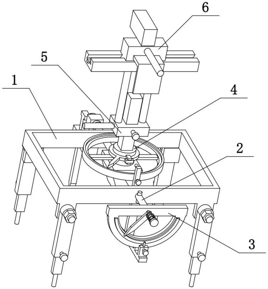
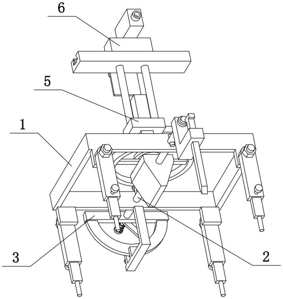
[0029] Combine below Figure 1-8 To illustrate this embodiment, the present invention relates to a surveying and mapping device, more specifically a portable surveying and mapping device with a recording function, including a rectangular frame 1, an L-shaped rod 106, a clip 107, a fastening screw II 108, and an inclined pointer 109 , horizontal axis 2, trapezoidal weight 202, front bar 3, sleeve column 301, toggle pointer 1303, semicircle ruler 304 and optical surveying instrument 601, the present invention can rotate to the angle of horizontal state to optical surveying instrument 601 on inclined ground Recording is convenient for observing the surveying and mapping environment of the optical mapping instrument 601 .

[0030]The front and rear ends of the horizontal shaft 2 are respectively rotatably connected to the middle of the front and rear sides of the rectangular frame 1, and the middle of the horizontal shaft 2 is fixedly connected with a trapezoidal weight 202, which...

specific Embodiment approach 2

[0032] Combine below Figure 1-8 To illustrate this embodiment, the surveying and mapping device also includes a disc 302, the front end of the sleeve 301 is fixedly connected with the disc 302, and the sleeve 301 is sleeved with a compression spring I, and the compression spring I is located between the disc 302 and the toggle pointer I303 between. The disc 302 blocks the front side of the compression spring 1, and the compression spring 1 on the sleeve 301 fixes the pointer 1303 so that the pointer 1303 can be fixed when it rotates to a certain position and will not rotate at will, so that the pointer 1303 can record the optical mapping instrument 601 is the angle at which the sloping ground turns to a horizontal state.

specific Embodiment approach 3

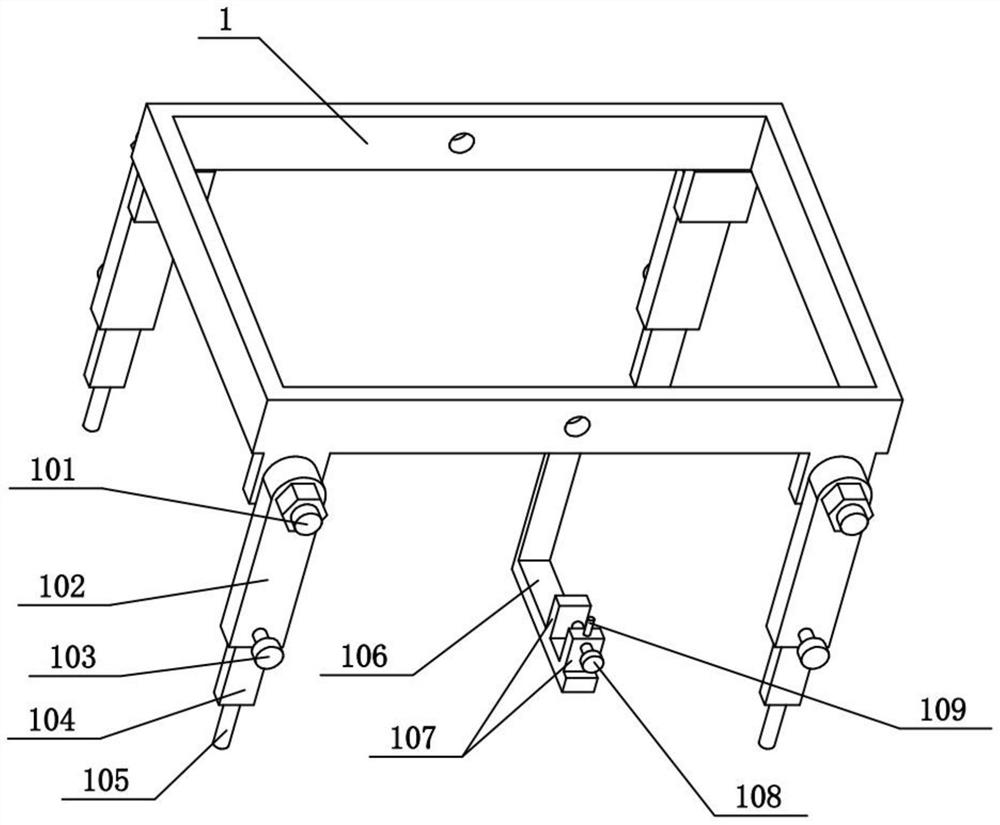
[0034] Combine below Figure 1-8 To illustrate this embodiment, the surveying and mapping device also includes a threaded post 101, a hollow post 102, a fastening screw 1103, a solid post 104, and pins 105, and two threaded posts 101 are fixedly connected to the front and rear sides of the rectangular frame 1. The tops of the four hollow pillars 102 are rotatably connected to the four threaded pillars 101 respectively, and the four threaded pillars 101 are all threadedly connected with nuts, and the four nuts are respectively pressed on the four hollow pillars 102, and the bottoms of the four hollow pillars 102 All are slidably connected with solid pillars 104, and the lower parts of the four hollow pillars 102 are all threaded with fastening screws I103, and the four fastening screws I103 are respectively supported on the four solid pillars 104, and the lower parts of the four solid pillars 104 are all fixed. Pin 105 is connected. Hollow pillar 102 can be rotated on threaded...


PUM


Abstract

The present invention relates to a surveying and mapping device, more specifically a portable surveying and mapping device with recording function, which includes a rectangular frame, an L-shaped rod, a clip, a fastening screw II, an inclined pointer, a horizontal axis, a trapezoidal weight, a front Horizontal bar, sleeve post, toggle pointer I, semicircle ruler and optical surveying instrument, the present invention can record the angle that optical surveying instrument rotates to horizontal state on inclined ground, is convenient to observe the surveying and mapping environment of optical surveying instrument. The front and rear ends of the horizontal axis are respectively connected to the middle of the rectangular frame, and the middle of the horizontal axis is fixedly connected with a trapezoidal weight, which is wide at the top and narrow at the bottom. The front end of the horizontal axis is fixedly connected with the front horizontal bar, the lower side of the front horizontal bar is fixedly connected with a semi-circular ruler, the outer edge of the semi-circular ruler is provided with a scale, the middle part of the front horizontal bar is fixedly connected with a sleeve column, and the upper end of the pointer I is rotated Connected to the sleeve, the relative position of the toggle pointer I and the sleeve can be fixed.

Description

technical field [0001] The invention relates to a surveying and mapping device, in particular to a portable surveying and mapping device with recording function. Background technique [0002] The application number is CN201820825496.X, which discloses a special handheld surveying and mapping device for construction sites. The utility model provides a special handheld surveying and mapping device for construction sites, including: a surveying and mapping device, a laser transmitter, and a handle; The lower part of the outer wall of the front end of the surveying and mapping device, and the laser transmitter and the surveying and mapping device are connected by embedding; the photosensitive receiver is arranged on the upper part of the outer wall of the front end of the surveying and mapping device, and the photosensitive receiver and the surveying and mapping device are connected by embedding; the rotating shaft The seat is arranged on the outer walls of both sides of the sur...

Claims


Application Information

Patent Timeline
Patent Type & Authority Patents(China)
IPC IPC(8): G01C15/00F16M11/34F16M11/24F16M11/04F16M11/08B43L5/00
CPCB43L5/00F16M11/046F16M11/08F16M11/245F16M11/34G01C15/008
Inventor 刘平利乔天荣张鸿祥王传先崔明军刘松源高健陶诚常城
Owner 刘平利
Why Eureka
Try Eureka