

A dual-mode satellite fusion positioning method suitable for ship traffic management system
A technology for ship traffic management and fusion positioning, applied in the field of dual-mode satellite fusion positioning, which can solve the problems of inability to obtain positioning results and guarantee optimality, and achieve improved safety and fault tolerance, reduced complexity, and improved positioning accuracy. Effect
- Summary
- Abstract
- Description
- Claims
- Application Information
AI Technical Summary
Problems solved by technology
Method used
Image

Examples
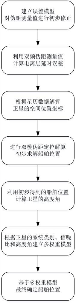
Embodiment Construction
2
are expressed as:
[0068]
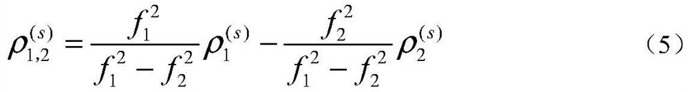
In formula (3), f
1
and f
2
respectively represent the two different carrier frequencies of the satellite signal.
If this satellite is Beidou satellite, then receive B1I signal and B3I signal, its carrier frequency is respectively 1561.098MHz
and 1268.520MHz; if the satellite is a GPS satellite, it will receive L1 signal and L5 signal, and its carrier frequencies are
1575.42MHz and 1176.45MHz.
Then, two equations in formula (1) are subtracted, and formula (3) is substituted into the equation after the subtraction, eliminating 40.28N
e
,
After finishing, the ionospheric delay error model can be obtained, as shown below:
[0072]
Then, the ionospheric delay 1 shown in formula (4)
1
and I
2
Substitute into the following formula:
[0074]
Thus, the pseudorange measurement value after the ionospheric delay correction is obtained as follows:
[0076]
[0077] In formula (5), it represents the pseudorange measurement value...
PUM
 Abstract
Description
Claims
Application Information