
Pick-up measuring method for checking road surface planeness

A technology of photogrammetry and detection method, applied in the direction of height/level measurement, photogrammetry/video measurement, measurement device, etc., can solve the problem that the instrument must be calibrated regularly, the international flatness index cannot be directly obtained, and the application of responsive detector Restrictions and other issues, to achieve the effect of high degree of digitization and automation, low degree of hardware dependence, and simple operation

Inactive Publication Date: 2008-02-20
张小虎 +3
View PDF0 Cites 32 Cited by
  • Summary
  • Abstract
  • Description
  • Claims
  • Application Information

AI Technical Summary

Problems solved by technology

Another type of responsive detection, its main limitation is that the instrument must be calibrated regularly, and the international flatness index IRI cannot be obtained directly
However, with the popularization and use of the international flatness index IRI and the requirements of the Ministry of Communications for IRI, the application of responsive detectors has also begun to be restricted

Method used


Image

  • Pick-up measuring method for checking road surface planeness
  • Pick-up measuring method for checking road surface planeness
  • Pick-up measuring method for checking road surface planeness

Examples


Embodiment Construction

[0061] Referring to Fig. 2, Fig. 4 and Fig. 5, the inventive method is:

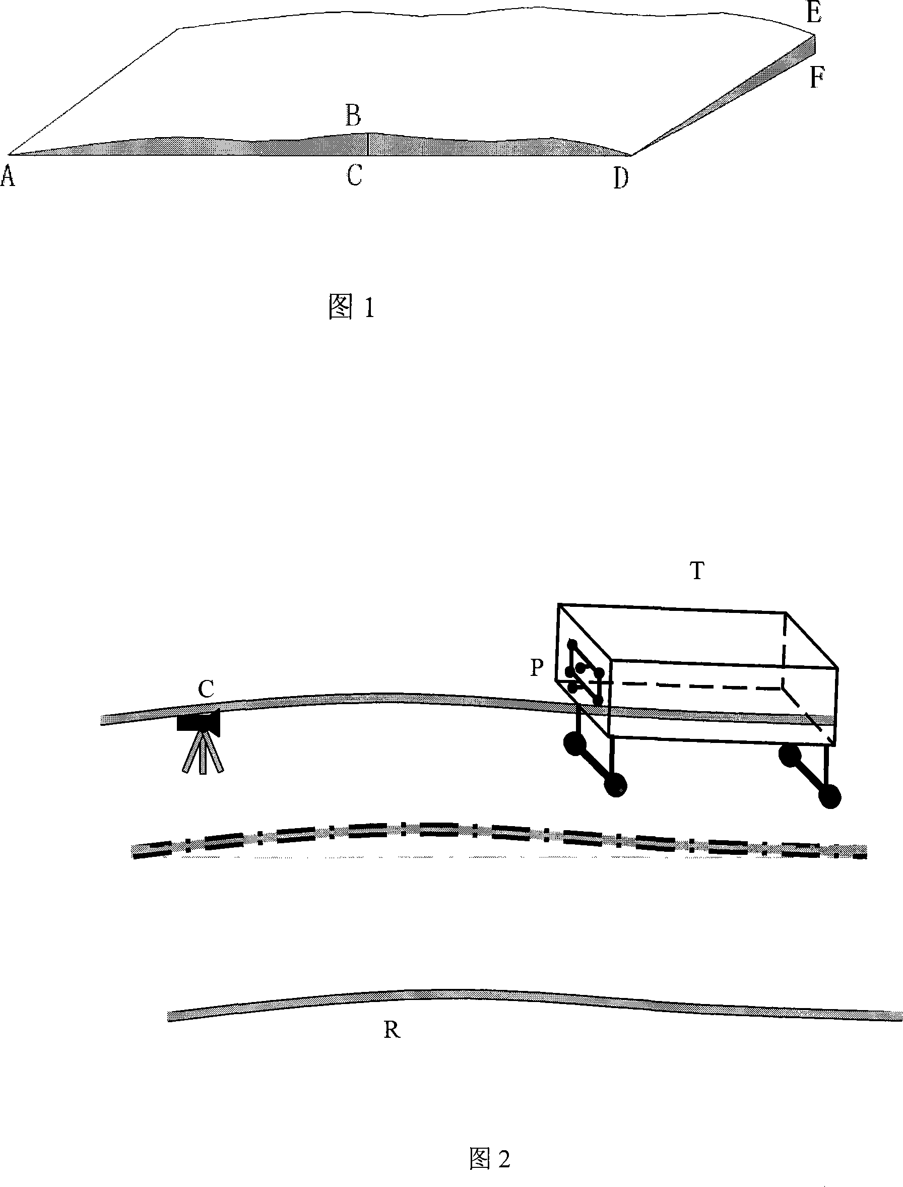
[0062] a. Place the measuring vehicle T on the road surface R to be measured, fix six reference cooperation signs P on the measuring vehicle T, and place the camera device C on the ground in front of the vehicle body; the measuring vehicle T is shown in Figure 2 Four-wheeled trolley.

[0063] b. When the measuring vehicle T is running on the road surface R to be measured, use the camera device C to take images of the cooperation sign P at different moments during the running process of the measuring vehicle T;

[0064] c. Obtain the four road surface roughness parameters of elevation, sampling interval, longitudinal slope, and transverse slope in real time through image processing and the profile curve of the longitudinal section.

[0065] An example synthesis method of the road surface roughness parameter is as follows.

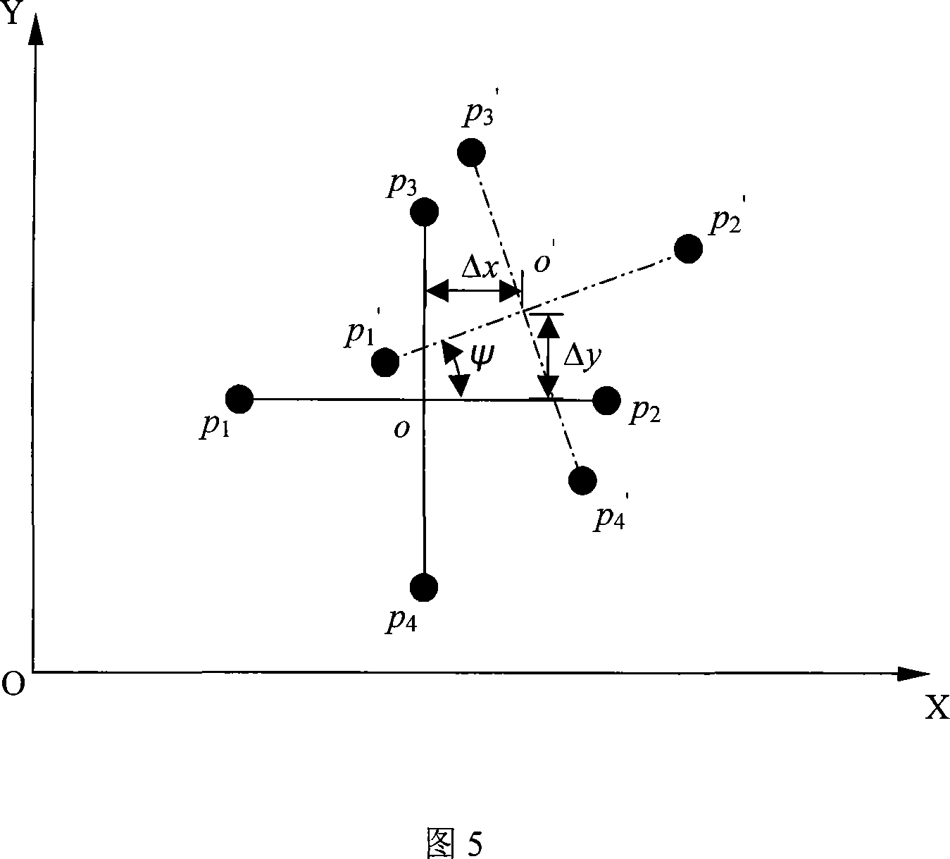
[0066] As shown in Figure 5, O is the center of the image, and XOY is the image ...


PUM


Abstract

The utility model relates to a video measuring method for smoothness of road surface, which is characterized in that cooperation signs are arranged at measuring cars, the measuring cars is parked on the road, reference cooperation signs are fixed on the measuring cars, and a video device is fixed on the ground in front of the cars; during the measuring cars is driven on the measured road, the pictures of cooperation signs at different time are taken by the video device; at least a parameter of four parameters including height, sample interval, vertical grade and horizontal grade are acquired through image processing; the four parameters are combined into vertical section curve. The measurement system using the method meets the development requirement of modern high way construction, high precision, high reliability, high automation measurement, and is applied in high way and airport project.

Description

technical field [0001] The present invention relates to engineering fields such as highway construction and airport runways, as well as disciplines such as digital photogrammetry, digital image processing, and computer vision. The method of obtaining the smoothness parameters of the road surface with high precision through the automatic analysis of the images of the moving cooperative markers. Background technique [0002] The roughness of the road surface mainly refers to the fluctuation of the profile curve of the longitudinal section of the road surface that causes the vehicle to vibrate during the driving process. The parameters of the roughness of the road surface mainly include four items: elevation, sampling interval, longitudinal slope, and transverse slope. Elevation refers to the deviation of the sampling point relative to the ideal plane. Generally, the horizontal plane where the starting point of measurement is located is taken as the ideal plane; sampling interv...

Claims


Application Information

Patent Timeline
Patent Type & Authority Applications(China)
IPC IPC(8): G01C11/00G01C11/36G01C5/00G01B11/00
Inventor 张小虎于起峰姜欣伏思华
Owner 张小虎
Learn More