Automatic identification method and device for coast erosion and sedimentation based on shoreline data

A technology of coastal erosion and identification methods, applied in scene recognition, image data processing, character and pattern recognition, etc., can solve the problems of limited interpretation accuracy, erosion, and time-consuming

Active Publication Date: 2020-07-28
MINISTRY OF ECOLOGY & ENVIRONMENT CENT FOR SATELLITE APPL ON ECOLOGY ENVIRONMENT
View PDF4 Cites 2 Cited by
  • Summary
  • Abstract
  • Description
  • Claims
  • Application Information

AI Technical Summary

Problems solved by technology

[0005] The traditional method is manual participation in the whole process. The advantage is that it is simple and easy to implement when the image background is simple, the tidal flat area changes greatly, and the coastal zone is small; but its shortcomings and shortcomings are also obvious, mainly in the face of small Gap area, visual observation and identification are relatively difficult, and ...

Method used


Image

  • Automatic identification method and device for coast erosion and sedimentation based on shoreline data
  • Automatic identification method and device for coast erosion and sedimentation based on shoreline data
  • Automatic identification method and device for coast erosion and sedimentation based on shoreline data

Examples


Embodiment 1

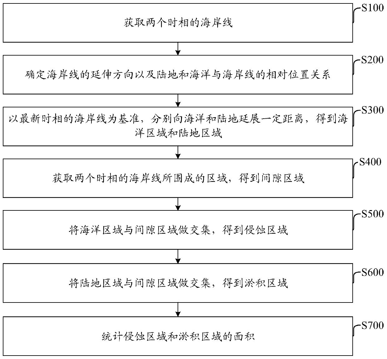
[0095] An embodiment of the present invention provides an automatic identification method for coastal erosion and deposition based on shoreline data, such as figure 1 As shown, the method includes:

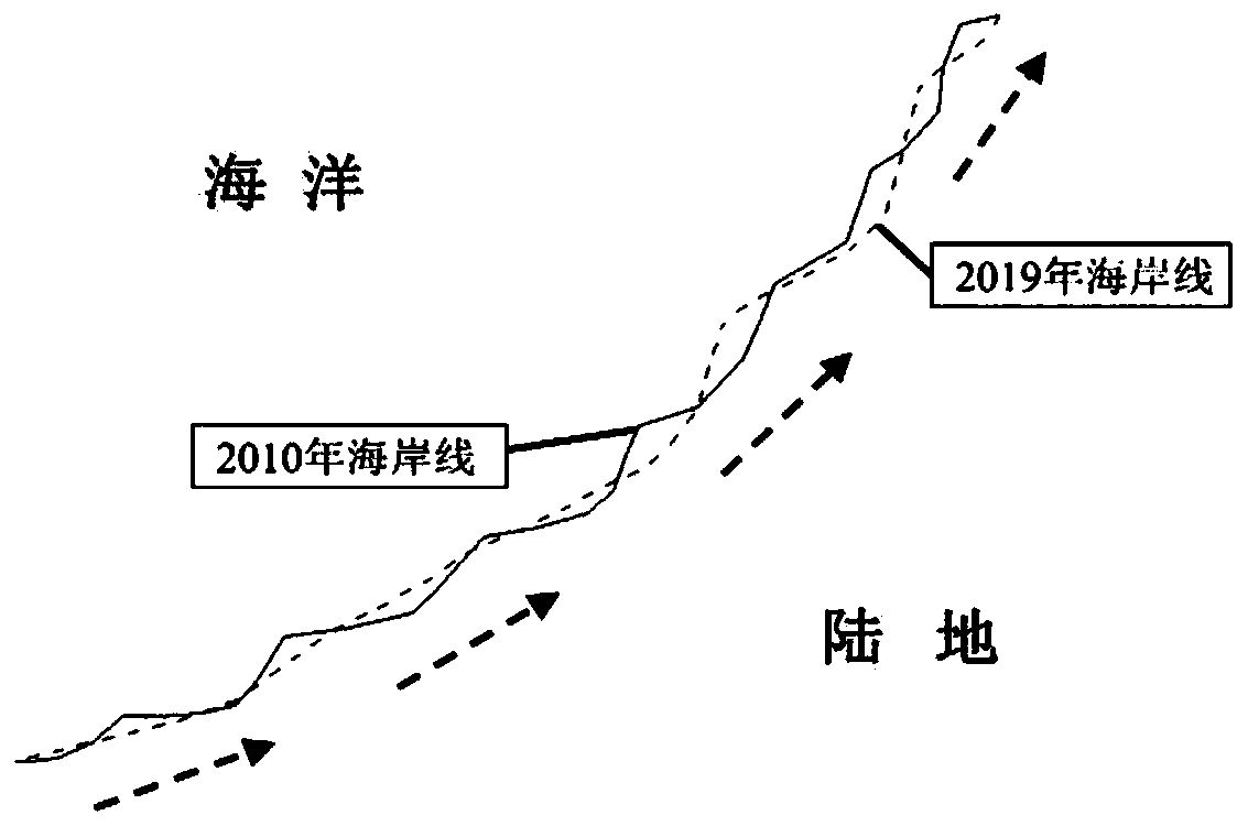
[0096] S100: Obtain the coastlines in two phases, such as figure 2 shown.

[0097] The present invention does not limit the means of obtaining the coastline, which can be the existing coastline data, which can be directly used, or the coastline data obtained by extracting the remote sensing image, but the technical means of obtaining the coastline of the two time phases must be the same , to ensure that the extracted erosion and deposition areas can exclude the influence of human factors, which is convenient for subsequent erosion and deposition analysis. Generally, coastline data exists in the form of vector data.

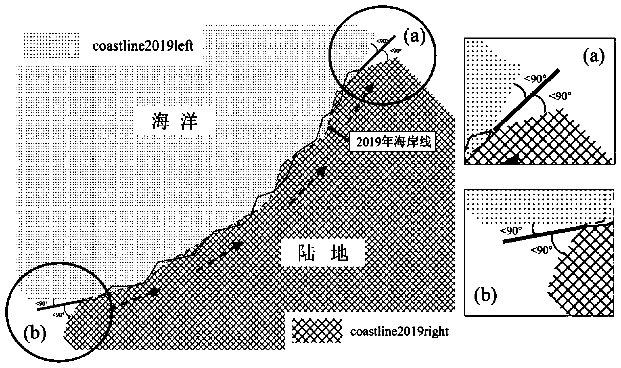
[0098] S200: Determine the extension direction of the coastline and the relative positional relationship between land and sea and the coastline, such as figure ...

Embodiment 2

[0202] An embodiment of the present invention provides an automatic identification device for coastal erosion and deposition based on shoreline data, such as Figure 7 As shown, the device includes:

[0203] The coastline acquisition module 1 is used to acquire the coastlines in two phases.

[0204] The extension direction and relative position determination module 2 is used to determine the extension direction of the coastline and the relative position relationship between the land and sea and the coastline.

[0205] The extension module 3 is used to extend a certain distance to the ocean and the land respectively based on the coastline in the latest time phase to obtain the ocean area and the land area.

[0206] The gap area determination module 4 is configured to obtain the area enclosed by the coastlines of the two time phases to obtain the gap area.

[0207] The erosion area determination module 5 is used to intersect the ocean area and the interstitial area to obtain the...


PUM


Abstract

The invention discloses an automatic identification method and device for coast erosion and sedimentation based on shoreline data, and belongs to the field of ocean monitoring. The method comprises the following steps: firstly, acquiring coastline vector data of two time phases, and respectively performing topology check on the coastline vector data to ensure that a coastline has two end points and does not coincide with each other; secondly, based on coastline vector data of two time phases, according to a specific spatial analysis method, automatically obtaining a gap region, automatically giving two attributes of sedimentation and erosion according to a certain rule, carrying out consistency check and precision evaluation, and finally obtaining the distribution range and area of sedimentation and erosion. The method and device can automatically extract erosion and sedimentation areas, reduce misjudgment, erroneous judgment and missed judgment caused by artificial interpretation, improve the detection speed, and quickly and accurately obtain the dynamic change of coastal zone intertidal zone information.

Description

technical field [0001] The invention relates to the field of marine monitoring, in particular to an automatic identification method and device for coastal erosion and deposition based on shoreline data. Background technique [0002] The coastal zone is the key zone for the interaction between the ocean and the land. As the boundary between the sea and the land, the coastline not only records the changes of the coastal tidal flats and the decline of the wetland ecosystem, but also its spatial fluctuation and property changes reflect the transformation of the coastal zone's erosion-siltation process and The way and dynamic process of human development, utilization and protection of coastline. [0003] The intertidal zone of the coastal zone is affected by natural and human effects, and periodically changes the landform of the coast. For example, the land in the intertidal zone is silted toward the sea to form a tidal flat wetland, or the coast is eroded by natural disasters to...

Claims


Application Information

Patent Timeline
IPC IPC(8): G06K9/00G06K9/46G06T7/30G06T7/62
CPCG06T7/30G06T7/62G06T2207/10032G06T2207/30181G06V20/13G06V10/462
Inventor 马万栋毕京鹏张文国申文明毕晓玲蔡明勇史园莉张雪王丽霞陈绪慧申振史雪威张宏伟
Owner MINISTRY OF ECOLOGY & ENVIRONMENT CENT FOR SATELLITE APPL ON ECOLOGY ENVIRONMENT
Why Eureka
Try Eureka