A method of establishing urban plane coordinate system based on dem

A system establishment and plane coordinate technology, applied in the field of surveying and mapping science and engineering, can solve problems such as the inability to accurately and intuitively select the projection surface, the abnormally large elevation, and the unquantifiable calculation of the area of ​​the area, etc.

Active Publication Date: 2021-04-02
昆明市测绘研究院
View PDF5 Cites 0 Cited by
  • Summary
  • Abstract
  • Description
  • Claims
  • Application Information

AI Technical Summary

Problems solved by technology

[0022] 1. Although the traditional method can meet the requirements of most of the projection deformation (2.5cm / km) in the region, it cannot quantitatively calculate the area that can be controlled to meet the projection surface deformation requirements, especially in high-altitude areas or terrain fluctuations. large area
[0023] 2. When the urban administrative area is large and a single projection surface cannot meet the urban projection deformation requirements (2.5cm / km), the traditional method cannot accurately and intuitively select the projection surface; at the same time, it is also impossible to quantitatively calculate each projection surface The area that can be controlled; the range controlled by the determined projection surface cannot be visualized and intuitively expressed
[0024] 3. In the traditional calculation method, when calculating the projection deformation, the measured side length is generally calculated using the altitude instead of the geodetic height when calculating the reference ellipsoid, but the elevation anomaly is relatively large in western China (less than -30m and below ), has a great influence on the projection deformation and has a great influence on the calculation results, so it is necessary to use the geodetic height to calculate the projection deformation
[0025] 4. The traditional calculation method has a large amount of calculation, low calculation efficiency, and unclear quantitative indicators. Especially in areas with large urban areas and large elevation fluctuations, it is impossible to calculate large-area multi-projection zones and multi-projection surfaces, and cannot realize automatic calculation. calculate

Method used


Image

  • A method of establishing urban plane coordinate system based on dem
  • A method of establishing urban plane coordinate system based on dem
  • A method of establishing urban plane coordinate system based on dem

Examples


Embodiment Construction

[0107] The following will clearly and completely describe the technical solutions in the embodiments of the present invention with reference to the accompanying drawings in the embodiments of the present invention. Obviously, the described embodiments are only some, not all, embodiments of the present invention. Based on the embodiments of the present invention, all other embodiments obtained by persons of ordinary skill in the art without making creative efforts belong to the protection scope of the present invention.

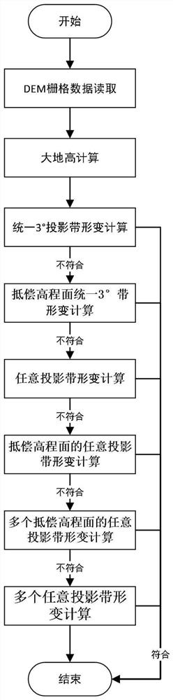
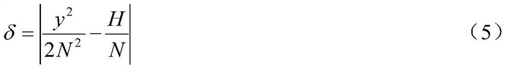
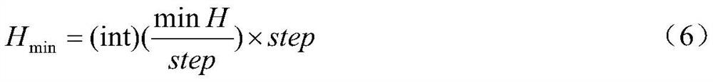
[0108] The processing object of the embodiment of the present invention is DEM data within the area (resolution is better than 100m, precision is better than 20m), the coordinate system is the 2000 national geodetic coordinate system or the WGS84 coordinate system, the elevation is normal high (high above sea level), and the data format It is a commonly used DEM data format. A method for establishing a DEM-based urban plane coordinate system, the specific impl...


PUM


Abstract

The invention discloses a DEM-based city plane coordinate system establishment method. The method comprises the following steps of firstly, carrying out unified 3-degree projection band deformation and if the deformation requirement cannot be met, compensating the uniform 3-degree zone deformation of the elevation plane, and if the deformation requirement cannot be met, performing any projection zone deformation, any projection zone deformation of an elevation plane, any projection zone deformation of the plurality of compensation elevation planes and any projection zone deformation of the plurality of compensation elevation planes in the same manner until the projection deformation meets the requirement. Compared with a traditional calculation method, the method is higher in calculation efficiency and more reliable in result, meanwhile, the area, capable of being controlled, of the area meeting the deformation requirement of the projection plane can be quantitatively calculated, and the result is visualized.

Description

technical field [0001] The invention belongs to the field of surveying and mapping science and engineering technology, and relates to a method for establishing a city plane coordinate system based on DEM. Background technique [0002] The coordinate system plays a very important role in the development and quality control of surveying and mapping work, and plays an irreplaceable role in urban planning, construction, surveying and mapping management, etc. Strengthening the construction of the urban coordinate system is conducive to the planning, development and construction of the city. The construction of a coordinate system is the basis of surveying and mapping. According to the requirements of CJJ / T8 "Urban Measurement Specifications", the urban plane control network must adopt the unified coordinate system, and must meet the following conditions: [0003] (1) The central area of ​​the city is located near the central meridian of the Gaussian conformal projection unified...

Claims


Application Information

Patent Timeline
Patent Type & Authority Patents(China)
IPC IPC(8): G06T17/05G06T17/20
CPCG06T17/05G06T17/20G06T2200/04
Inventor 王友昆谢正明张君华余章蓉陈裕汉
Owner 昆明市测绘研究院
Why Eureka
Try Eureka