Inland river complex water area underwater topography measurement system and method

An underwater topography and measurement system technology, applied in the field of surveying and mapping science, can solve problems such as falls, injuries, high operation risks, and low efficiency, and achieve the effects of low safety risks and high operation efficiency.

Pending Publication Date: 2020-07-31
SHANGHAI WATERWAY ENG DESIGN & CONSULTING CO LTD
View PDF0 Cites 5 Cited by
  • Summary
  • Abstract
  • Description
  • Claims
  • Application Information

AI Technical Summary

Problems solved by technology

Due to obstacles in the measurement area, there are bumps and entanglements when using small boats for measurement, and there are safety risks such as falls and falls in manual walking measurement. Both small boat measurement and manual walking measurement have disadvantages such as high operational risk and low efficiency.
Therefore, there is still a lack of an efficient, convenient and low-cost underwater topographic measurement system in the existing field of underwater topographic measurement in complex waters of inland rivers

Method used


Image

  • Inland river complex water area underwater topography measurement system and method
  • Inland river complex water area underwater topography measurement system and method
  • Inland river complex water area underwater topography measurement system and method

Examples


Embodiment 1

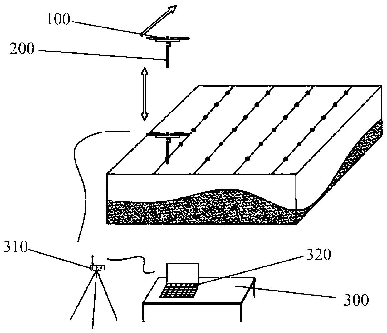
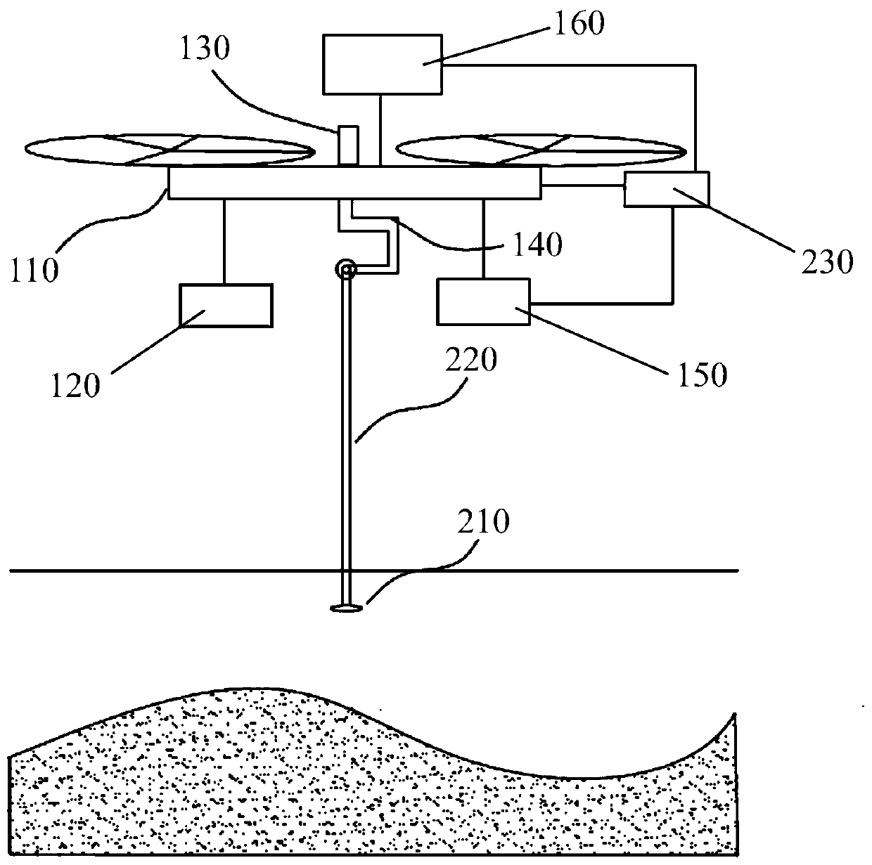
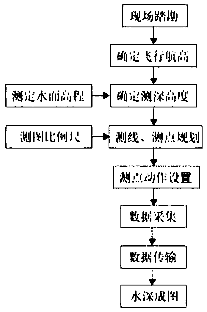
[0028] figure 1 It is a diagram of the working mode of the present invention. figure 2 It is a structural schematic diagram of the present invention. image 3 It is the operation flow chart of the present invention.

[0029] Such as Figure 1-3 As shown, a system for underwater terrain surveying in complex waters of inland rivers includes: an unmanned aerial vehicle system 100, a small depth sounder 200 and a ground station system 300, the small depth sounder 200 is connected to the lower part of the unmanned aerial vehicle system 100, and the ground station system 300 is connected with UAV system 100;

[0030] Among them, the UAV system 100 includes: UAV 110, high-voltage battery module 120, GNSS module 130, self-stabilizing platform 140, flight control module 150 and data transmission module 160, high-voltage battery module 120 and flight control module 150 and wireless The man-machine 110 is connected in the abdomen, the GNSS module 130 and the data transmission module...


PUM


Abstract

An inland river complex water area underwater topography measurement system comprises an unmanned aerial vehicle system, a small depth finder and a ground station system, the small depth finder is connected with the lower portion of the unmanned aerial vehicle system, and the ground station system is connected with the unmanned aerial vehicle system. The unmanned aerial vehicle system comprises anunmanned aerial vehicle, a high-voltage battery module, a GNSS module, a self-stabilization holder, a flight control module and a data transmission module. The unmanned aerial vehicle system is additionally arranged, the unmanned aerial vehicle is adopted as a carrier, the unmanned aerial vehicle is automatically remotely controlled to fly to a measuring point, and automatically descends until adepth finder transducer is immersed in a position 10-20 cm below the water level, and the unmanned aerial vehicle position and depth measurement information are returned to the ground station system through the unmanned aerial vehicle data transmission module, so underwater topographic measurement is automatically implemented in the whole process, measurement data can be transmitted back to the ground station in real time in a wireless mode, manual wading measurement is not needed, the safety risk is low, and the operation efficiency is high.

Description

technical field [0001] The invention relates to the field of surveying and mapping science and technology, in particular to an underwater terrain measurement system and method for complicated inland river waters. Background technique [0002] Underwater topography measurement in areas with dense obstacles such as riprap and fishing nets has always been a difficult point in marine surveying and mapping. The traditional measurement method is to use a boat to carry a depth sounder or use a manual handheld GNSS-RTK wading measurement. Due to obstacles in the measurement area, there are bumps and entanglements when using small boats for measurement, and there are safety risks such as falls and falls in manual walking measurement. Both small boat measurement and manual walking measurement have disadvantages such as high operational risk and low efficiency. Therefore, there is still a lack of an efficient, convenient, and low-cost underwater topographic measurement system in the ex...

Claims


Application Information

Patent Timeline
Patent Type & Authority Applications(China)
IPC IPC(8): G01S15/88G01S15/08G01S19/42G01C13/00G01C7/04B64C39/02
CPCG01S15/88G01S15/08G01S19/42G01C13/008G01C7/04B64C39/024B64U2101/00Y02A90/30
Inventor 杨俊凯颜惠庆杨振林王长永胡小雷于峰陈尚登闵建雄
Owner SHANGHAI WATERWAY ENG DESIGN & CONSULTING CO LTD
Why Eureka
Try Eureka