Self-adaptive geospatial grid indexing method

An adaptive grid and geospatial technology, applied in the index field, can solve the problem of low retrieval efficiency, achieve the effect of improving efficiency, high query efficiency, and reducing the number of grids

Active Publication Date: 2020-08-18
苏州清研捷运信息科技有限公司
View PDF3 Cites 5 Cited by
  • Summary
  • Abstract
  • Description
  • Claims
  • Application Information

AI Technical Summary

Problems solved by technology

[0007] Aiming at the deficiencies of the prior art, the present invention provides an adaptive geospatial grid indexing method, which solves the problem of low retrieval efficiency of the existing grid indexing technology and quadtree indexing technology

Method used


Image

  • Self-adaptive geospatial grid indexing method
  • Self-adaptive geospatial grid indexing method

Examples


Embodiment

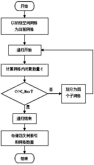
[0029] like figure 1 As shown, the embodiment of the present invention provides an adaptive geospatial grid indexing method, the indexing method includes a method for establishing an adaptive geospatial grid index and a method for using the adaptive grid index for spatial data retrieval.

[0030] A method for establishing an adaptive geospatial grid index includes the following steps:

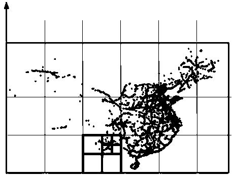
[0031] S1. Divide the primary grid. First divide the entire geographic space into primary grids with length and width S0 evenly according to the latitude and longitude. Store the storage objects in the corresponding primary grids accordingly. Select a value of S0 according to the actual application situation. A larger value ensures that the total number of primary grids is less;

[0032] S2. Recursively perform adaptive sub-grid division for each primary grid, the specific steps are as follows:

[0033] S2-1. Check the number C of storage objects in the current grid. If C<=C_Max, proceed to s...


PUM


Abstract

The invention provides a self-adaptive geospatial grid indexing method, and relates to the technical field of indexing methods. The self-adaptive geospatial grid indexing method comprises a self-adaptive geospatial grid index establishing method and a method for carrying out spatial data retrieval by using a self-adaptive grid index. The self-adaptive geospatial grid index establishing method comprises the following steps: S1, dividing primary grids, namely uniformly dividing the whole geospatial grid into primary grids with the length and the width of S0 according to longitude and latitude, and correspondingly storing storage objects into the corresponding primary grids. According to the self-adaptive geospatial grid indexing method designed by the invention, the balance between the queryefficiency and the storage efficiency can be ensured, the advantages of a quadtree index and a grid index are integrated, the grid searching efficiency is improved, the method is particularly suitable for storing and retrieving offline data on vehicle-mounted equipment with limited computing performance and storage space, and the data storage and query efficiency of vehicle-mounted navigation isimproved.

Description

technical field [0001] The invention relates to the technical field of indexing methods, in particular to an adaptive geographic space grid indexing method. Background technique [0002] In applications such as electronic maps and vehicle navigation, it is a basic requirement to query geographical objects within a certain spatial range. In the case of increasing map data, in order to ensure the query speed, it is necessary to establish a spatial index for the stored geographical objects. A basic technology for geographic data services. At present, the technology of establishing geospatial index mainly includes grid index technology and quadtree index technology. [0003] Grid indexing technology refers to dividing the entire geographical space into grids of a certain size, and organizing data according to the grid according to the location of the storage object. When querying, first determine the range of the grid, and only one or several nearby Data query in the grid. Us...

Claims


Application Information

Patent Timeline
Patent Type & Authority Applications(China)
IPC IPC(8): G06F16/22G06F16/29G06F16/2457
CPCG06F16/2246G06F16/29G06F16/2457
Inventor 闫建杰李兵朱文超周波杨扬
Owner 苏州清研捷运信息科技有限公司
Why Eureka
Try Eureka