
Long-endurance track real-time display method

A real-time display, long flight time technology, applied in the field of geographic information technology software development, can solve the problems affecting the smoothness of other operations of the software, stuttering and other problems, and achieve the effect of smooth operation without stuttering, correct display, and the same overall trend.

Inactive Publication Date: 2020-09-08
63653 FORCES PLA
View PDF5 Cites 0 Cited by
  • Summary
  • Abstract
  • Description
  • Claims
  • Application Information

AI Technical Summary

Problems solved by technology

[0003] However, due to the limitations of the Skyline platform itself, when the number of ship positioning data is close to or reaches the order of 10^5, the overhead of Skyline management trajectory objects will significantly affect the smoothness of other operations of the software, and there will be obvious lag

Method used


Image

  • Long-endurance track real-time display method
  • Long-endurance track real-time display method

Examples


Embodiment Construction

[0017] The following will clearly and completely describe the technical solutions in the embodiments of the present invention with reference to the accompanying drawings in the embodiments of the present invention. Obviously, the described embodiments are only some, not all, embodiments of the present invention. Based on the embodiments of the present invention, all other embodiments obtained by persons of ordinary skill in the art without making creative efforts belong to the protection scope of the present invention.

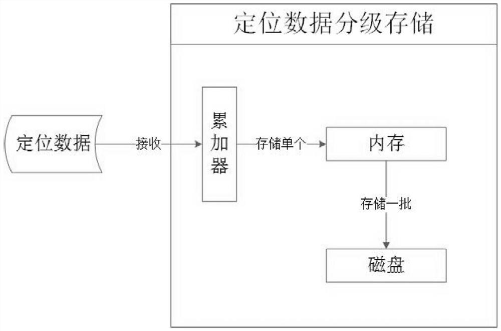
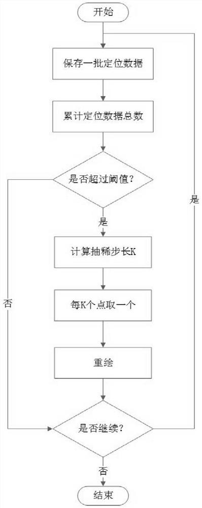
[0018] see Figure 1~2 , in an embodiment of the present invention, a real-time display method for a long-duration trajectory, the specific steps are as follows: S1: save the positioning data; S2: use the thinning algorithm to thin the positioning data and then draw it; S3: use the data stored on the disk Positioning data for trajectory recovery and redrawing.

[0019] In step S1, the specific steps for saving positioning data are as follows: ①. Using the ide...


PUM


Abstract

The invention discloses a long-endurance track real-time display method. The method comprises the following specific steps: S1, storing positioning data; S2, thinning the positioning data by using a thinning algorithm, and then drawing; and S3, carrying out track recovery and redrawing by using the positioning data stored on a magnetic disk, wherein in the step 1), the specific positioning data storage steps comprise: (1), storing the received positioning data in a memory by using the thought of hierarchical storage and IO aggregation; and (2) randomly writing a batch of received positioning data into the magnetic disk in a centralized manner. According to the method, the positioning data is drawn after being thinned by using the thinning algorithm, so that the storage quantity of the positioning data is reduced, and the problem of jamming of Skyline is solved. By using the method, the Skyline software can edit and display a trajectory in real time for a long time, the software runs smoothly for a long time and is not stuck, the number of positioning data needing to be drawn can be greatly reduced, the drawn trajectory is clear, trajectory information is displayed correctly, the overall trend is not changed, and the effect is ideal.

Description

technical field [0001] The invention relates to the field of geographic information technology software development, in particular to a real-time display method for long-duration trajectory. Background technique [0002] In navigation, locating ships, recording navigation track information and drawing their navigation tracks on the electronic map can provide safe channel information for ship navigation, which is of great significance for improving the information management level of ship dispatching. Skyline is an excellent 3D digital earth platform software that can use massive remote sensing aerial survey image data, digital elevation data and other 2D and 3D data to build a 3D scene that simulates the real world, and is widely used in the field of geographic information. [0003] However, due to the limitations of the Skyline platform itself, when the number of ship positioning data is close to or reaches the order of 10^5, the overhead of Skyline's management of track ob...

Claims


Application Information

Patent Timeline
Patent Type & Authority Applications(China)
IPC IPC(8): G09B29/00
CPCG09B29/005
Inventor 不公告发明人
Owner 63653 FORCES PLA
Learn More