Urban marginal area identification method and system

A recognition method and edge area technology, applied in character and pattern recognition, instruments, computer components, etc., can solve problems such as strong subjectivity, lack of objective mathematical methods, and disregard of mutation point noise, etc., to avoid human subjective factors The influence of the characteristics, the expression of features is fine and objective, and the effect of improving the recognition accuracy

Active Publication Date: 2020-09-11
南京图申图信息科技有限公司
View PDF3 Cites 8 Cited by
  • Summary
  • Abstract
  • Description
  • Claims
  • Application Information

AI Technical Summary

Problems solved by technology

However, this method is based on artificial thresholds, which is highly subjective and lacks objective mathematical methods
Using the Space continuous wavelet transform (SCWT) method to identify urbanization breakpoints, combined with Kernel Density Estimation (KDE) or proximity to define the urban-rural edge from the spatial pattern of breakpoints, has the following disadvantages: First, KDE Neither the nor the spatial proximity principle considers the noise of mutation points; second, both methods measure the similarity between objects through binary relations, making it difficult to mine meaningful structures from complex data
When there are adjacent mutation points with small local differences, due to the error accumulation caused by the transitivity of the characteristics of the mutation points, clustering with only binary relations cannot reflect the spatial shift of the mutation points

Method used


Image

  • Urban marginal area identification method and system
  • Urban marginal area identification method and system
  • Urban marginal area identification method and system

Examples


Embodiment Construction

[0059] Below in conjunction with specific embodiment, further illustrate the present invention, should be understood that these embodiments are only used to illustrate the present invention and are not intended to limit the scope of the present invention, after having read the present invention, those skilled in the art will understand various equivalent forms of the present invention All modifications fall within the scope defined by the appended claims of the present application.

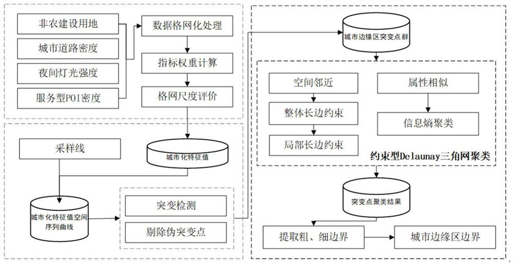
[0060] Such as figure 1 As shown, a method for identifying urban fringe areas with hollow features disclosed in the embodiment of the present invention mainly includes the following steps:

[0061] Step 1. Data grid processing

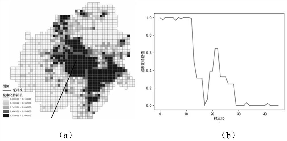
[0062] Obtain the land use data, urban road data, night light data, and POI (Point of Interest) data of the year to be studied, and perform grid processing. Among them, the land use data comes from relevant departments such as remote sensing image interpretation or plann...


PUM


Abstract

The invention discloses an urban marginal area identification method and system, and the method comprises the steps: c gridding obtained land utilization data, urban road data, night light data and POI interest point data, carrying out t weighted summation, obtaining an urbanization feature value of each grid, and optimizing the grid scale; extracting a sampling line to obtain an urbanization characteristic value space sequence curve; extracting mutation points based on spatial continuous wavelet transform, and eliminating false mutation points according to double standard deviation; constructing a triangulation network for all mutation points, deleting a global long edge and a local long edge, and clustering the mutation points based on regional attribute entropy; and finally, extractingthe boundary of the mutation point set in the clustering cluster based on a coarse edge criterion and a fine edge criterion so as to obtain the boundary of the identified urban edge region. Urbanization features can be expressed more finely and objectively, city edges with complex structures such as cavities can be identified, and the identification precision is improved.

Description

technical field [0001] The invention belongs to the technical field of geographic information processing, and relates to a method and system for identifying urban fringe areas. Background technique [0002] The urban-rural fringe area, also known as the urban fringe area, is the transition zone between urban and rural areas, where there are problems such as uneven distribution of service facilities, fragmented landscape, and waste of social resources. Therefore, it has been regarded as a key area to promote the development of scientific urbanization. The quantitative division of urban fringe areas is the key and prerequisite for further research on them, because only by accurately identifying the fringe can the driving factors of its formation and transformation be analyzed, and different planning, management, and policies implemented according to local conditions. [0003] Numerous studies have identified urban fringes according to different urbanization indices. Most of ...

Claims


Application Information

Patent Timeline
Patent Type & Authority Applications(China)
IPC IPC(8): G06K9/00G06K9/46G06K9/62
CPCG06V20/176G06V10/44G06F18/23Y02A30/60
Inventor 石凤杨晟
Owner 南京图申图信息科技有限公司
Why Eureka
Try Eureka