Check patentability & draft patents in minutes with Patsnap Eureka AI!

High altitude and profile plotting positioning method based on three-dimensional GIS map

A GIS map and plotting technology, applied in the directions of maps/plans/charts, image data processing, instruments, etc., can solve the problems such as the inability to visually display the relative positional relationship of combat elements, and the inability to accurately locate combat elements.

Active Publication Date: 2020-09-18
THE 28TH RES INST OF CHINA ELECTRONICS TECH GROUP CORP
View PDF4 Cites 5 Cited by
  • Summary
  • Abstract
  • Description
  • Claims
  • Application Information

AI Technical Summary

Problems solved by technology

The traditional three-digit digital earth platform default positioning point selection method is to calculate the world coordinates of the mouse point and the global camera, and create the ray of the two points, and obtain the intersection point of the ray and the surface of the three-dimensional digital earth as the positioning point; although this method can Correctly select the plotting points of objects located on the ground surface, but cannot accurately locate combat elements distributed in different physical space locations such as sky, sky, and network other than the ground surface, and cannot visually display the relative positional relationship of combat elements located in the same section

Method used


Image

  • High altitude and profile plotting positioning method based on three-dimensional GIS map
  • High altitude and profile plotting positioning method based on three-dimensional GIS map
  • High altitude and profile plotting positioning method based on three-dimensional GIS map

Examples


Embodiment

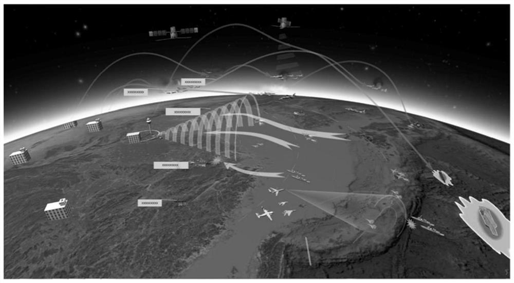
[0083] Example: Combine Figure 7 , the specific steps of using the three-dimensional model plotting of the present invention are:

[0084] (1) Determine the model object to be plotted, and the user searches and selects the model object from the model library by means of mouse interaction; the plotting system provides a fuzzy search function for the model name, which is convenient for fast retrieval and plotting;

[0085] (2) Matching the positioning method of plotting points, in view of the randomness of the plotting position of the model, the plotting system provides the three-dimensional digital earth surface plotting, high-altitude plotting and longitudinal profile plotting of the model. Surface plotting technology is used to plot the command post and tank models on the surface of the earth, and at the same time, it provides the automatic terrain matching function of the model, and the height position of the model is updated synchronously in each frame of the 3D digital ea...


PUM


Abstract

The invention provides a high altitude and profile plotting positioning method based on a three-dimensional GIS map. The high altitude and profile plotting positioning method comprises three modes ofsurface plotting, high altitude plotting and large-scale canvas plotting. Plotting point positioning and plotting modes can be automatically matched according to spatial positions and feature information of combat element distribution; surface element plotting points are positioned, world coordinates of a mouse point and a global camera are calculated, rays passing through the mouse point and thecamera point is created, and intersection points of the rays and the surface of the three-dimensional digital earth are solved; high-altitude element plotting points are positioned, an artifact enveloping ball is drawn, and an intersection point of a ray formed by the camera and the mouse point and the enveloping ball is taken as a graphic plotting point; and profile plotting operation is performed, a large-scale canvas is created to assist in completing high-altitude object drawing, and a position relationship between objects by referring to the profile of the canvas is visually obtained. According to the method, the earth surface element plotting positioning requirement is met, the problem that a high-altitude target cannot be plotted is solved, and meanwhile the position relation between profile objects is vividly displayed.

Description

technical field [0001] The invention relates to a high-altitude and profile plotting positioning method based on a three-dimensional GIS map. Background technique [0002] Situation plotting refers to plotting the distribution status or action deployment of various things with spatial characteristics on the map background, and visually expressing the intentions of command and decision-makers in symbolic language. It is widely used in military combat command and control application fields such as combat duty, training, simulated confrontation and military and emergency exercises. The battlefield situation map constructed through situation plotting uses realistic 3D models, graphic symbols with specific meanings, military logos or sound animations to represent the troops of both the enemy and us, the deployment of military facilities, and the combat process. It can not only represent the shape, position, structure and volume characteristics of the marked troops, command insti...

Claims


Application Information

Patent Timeline
Patent Type & Authority Applications(China)
IPC IPC(8): G06T17/05G09B29/00
CPCG06T17/05G09B29/007
Inventor 杨光周传龙陈伟伟蒉露超黄婧占伟伟张一鸣
Owner THE 28TH RES INST OF CHINA ELECTRONICS TECH GROUP CORP
Features
  • R&D
  • Intellectual Property
  • Life Sciences
  • Materials
  • Tech Scout
  • Unparalleled Data Quality
  • Higher Quality Content
  • 60% Fewer Hallucinations
Learn More