A Sunlight Avoidance Attitude Planning Method for Optical Satellite Phased Array Data Transmission Mission
An optical satellite and phased array technology, applied in the aerospace field, can solve the problems of camera failure, focal plane detector coating damage stability, affecting the service life of the camera, etc., to achieve the effect of improving the service life of the on-orbit
- Summary
- Abstract
- Description
- Claims
- Application Information
AI Technical Summary
Problems solved by technology
Method used
Image

Examples
Embodiment 2
[0095] The satellite simulation orbit parameters implemented by this patent are as follows:
[0096] Orbit type: Sun-synchronous orbit.
[0097] Orbit height: 535.35km.
[0098] Descending node local time: 11:30AM.
example 1
[0100] Data transmission start time: 641493087 (12:31:27 on April 30, 2020, Beijing time);
[0101] Data transmission time: 632 seconds.
[0102] Phased array maximum beam angle: 60°.
[0103] The location of the virtual data transmission station: longitude 110.189°, latitude 41.0451°, height 0m.
[0104] Satellite WGS84 position (m) at the start of data transmission: [-1606925.8, 2999967.7, 6017830.7].
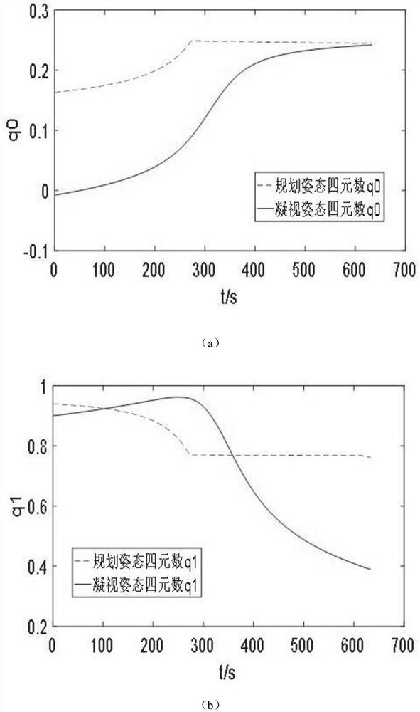
[0105] Satellite WGS84 speed (m / s) at the start of data transmission: [-1004.589, 6688.393, -3602.505]. Comparing the traditional gaze attitude and the planned attitude during the phased array digital transmission, the quaternion of the expected coordinate system relative to the J2000 system under the two phased array digital transmission attitudes is as follows: image 3 .
[0106] The angle and difference between the optical axis of the camera and the sunlight under the two attitudes of phased array digital transmission are as follows Figure 4 .
[0107] The simulati...
example 2
[0109] Data transmission start time: 659985344 (Beijing time at 13:15:44 on November 30, 2020).
[0110] Data transmission time: 624 seconds.
[0111] Phased array maximum beam angle: 70°.
[0112] Virtual data transmission station location: longitude 95.1138°, latitude 53.4442°, height 0m.
[0113] Satellite WGS84 position (m) at the start of data transmission: [-991897.472, 1985971.071, 6547393.436].
[0114] Satellite WGS84 speed (m / s) at the start of data transmission: [-12.387464, 7330.337414, -2225.332154].
[0115] Comparing the traditional gaze attitude and the planned attitude during the phased array digital transmission, the quaternion of the expected coordinate system relative to the J2000 system under the two phased array digital transmission attitudes is as follows: Figure 5 .
[0116] The angle and difference between the camera optical axis and the sunlight under two phased array digital transmission attitudes are as follows: Figure 6 .
[0117] The simul...
PUM
 Abstract
Description
Claims
Application Information