
Environment-friendly intelligent map based on GIS and application thereof

An environmentally friendly and intelligent technology, applied in data processing applications, geographic information databases, instruments, etc., can solve problems such as standardization, informatization, and poor intelligent management, and achieve informatization, good technical effects, standardization and environmental protection. The effect of management process informatization

Pending Publication Date: 2020-09-22
CHINA PETROLEUM & CHEM CORP +1
View PDF6 Cites 0 Cited by
  • Summary
  • Abstract
  • Description
  • Claims
  • Application Information

AI Technical Summary

Problems solved by technology

[0004] One of the technical problems to be solved by the present invention is the problem of poor standardization, informatization, and intelligent management in the prior art. A new GIS-based environmental protection intelligent map is provided, which has good standardization, informatization, and intelligent management. advantage

Method used


Image

  • Environment-friendly intelligent map based on GIS and application thereof

Examples


Embodiment 1

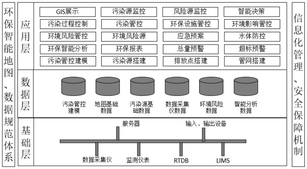
[0017] A GIS-based environmental intelligence map, such as figure 1 As shown, build an environmental protection intelligent map to realize the informatization and intelligence of environmental protection process management. According to the business needs of the enterprise's environmental protection, the designed environmental protection intelligent map mainly has 5 modules, which are GIS display, pollution process control, environmental risk control, environmental protection intelligent analysis and pollution control modeling, which enhances the initiative of pollution source monitoring and management and timeliness, realizing the standardization of environmental protection business process and informatization of environmental protection management process.

[0018] The construction content of the environmental protection intelligent map covers 5 modules, and the present invention explains the function of the environmental protection intelligent map with 5 modules, specifical...


PUM


Abstract

The invention relates to an environment-friendly intelligent map based on a GIS and application of the environment-friendly intelligent map, and mainly solves the problem of poor standardization, informatization and intelligent management in the prior art. According to the GIS-based environment-friendly intelligent map, information technologies such as automatic control, network communication, a computer, a GIS and big data are introduced into the field of environmental protection maps; the environmental protection intelligent map system for centralized display analysis and decision making ofthe enterprise environmental protection information is established, the technical scheme of comprehensively implementing pollution source intelligent monitoring and environmental protection governancefacility dynamic management well solves the problems, and the method can be used in the environmental protection management process.

Description

technical field [0001] The invention relates to a GIS-based environmental intelligent map and its application. Background technique [0002] It is an inevitable trend in the development of environmental protection management to introduce automatic control, network communication, computer, GIS and big data and other information technologies into the field of environmental protection management, and to establish a GIS-based environmental protection intelligent map and structure. GIS is a specific and very important geographic information technology. Using the powerful geographic information analysis function of GIS, the comprehensive display function of the online monitoring system of pollution sources can be established, which can timely and accurately grasp the operation of each enterprise's discharge outlets and the concentration changes of pollutant emissions. Trends, and functions such as monitoring point information query, pollution source analysis, and over-standard ala...

Claims


Application Information

Patent Timeline
Patent Type & Authority Applications(China)
IPC IPC(8): G06F16/29G06Q50/26
CPCG06Q50/26
Inventor 杨文玉牟桂芹周志国高阳李焕丁禄彬汪皕喆曲聪
Owner CHINA PETROLEUM & CHEM CORP
Learn More