Path planning method and path planning system

A route planning and routing technology, which is applied in the aviation field, can solve problems such as safety accidents, unfavorable traffic safety management, navigation, and geographic information update safety hazards, and achieve the effect of avoiding traffic conflicts, avoiding safety accidents, and facilitating traffic safety management

Active Publication Date: 2022-05-20
上海波若智能科技有限公司
View PDF0 Cites 0 Cited by
  • Summary
  • Abstract
  • Description
  • Claims
  • Application Information

AI Technical Summary

Problems solved by technology

[0005] 1. The flight area of ​​the airport does not belong to the open space (aviation control). In a relatively closed environment, if the traffic, navigation, and geographic information in the airport flight area are not updated in time, it is easy to cause safety hazards
[0006] 2. Traffic, navigation, geographic information, etc. are not updated in time, which is not conducive to traffic safety management in the airport flight area, and traffic conflicts (traffic conflicts between vehicles, traffic conflicts between vehicles and aircraft, etc.) are prone to occur, resulting in safety accidents
[0007] 3. The existing technical solutions, once a traffic conflict occurs in the airport flight area (even if no accident occurs), it will also affect the operation of vehicles and aircraft in the traffic conflict area (or adjacent areas)
Vehicles and aircraft without traffic conflicts need to be dispatched manually (or even stand by), which seriously affects the efficiency of airport operations

Method used


Image

  • Path planning method and path planning system

Examples


no. 1 example

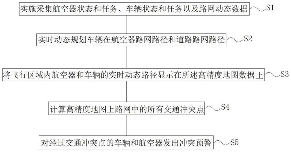
[0090] The present invention provides a first embodiment of a path planning method for an airport flight area, including the following steps:

[0091] S1, real-time collection of aircraft operating status in the airport flight area, vehicle driving status and vehicle task assignment status in the mission, road network dynamic data, vehicle traffic status and aircraft traffic status;

[0092] S2, according to the data collected in step S1, real-time dynamic planning of vehicle road network path and road network path;

[0093] S3, using high-precision map data, displaying the real-time dynamic paths of aircraft and vehicles in the flight area on the high-precision map data;

[0094] S4, calculating all traffic conflict points in the road network on the high-precision map;

[0095] S5, issuing a conflict warning to vehicles and aircraft passing through the traffic conflict point.

[0096] The first embodiment of the path planning method of the present invention collects in real...

no. 2 example

[0097] The present invention provides the second embodiment of the path planning method for the airport flight area, including the following steps:

[0098] S1, real-time collection of aircraft operating status in the airport flight area, vehicle driving status and vehicle task assignment status in the mission, road network dynamic data, vehicle traffic status and aircraft traffic status;

[0099] Aircraft operating status includes, but is not limited to, landing status, arrival taxi status, parking stand; departure taxi status, take-off status and flight status;

[0100] The driving state of the vehicle in the task includes driving, waiting, parking and parking work;

[0101] Vehicle task assignment status includes, but is not limited to, vehicle assignment tasks and vehicle current task changes; vehicle assignment tasks, that is, the starting point and end point of the vehicle are specified, and the route is usually planned with the shortest driving distance on the premise t...


PUM


Abstract

The invention discloses a path planning method for an airport flight area, which includes real-time collection of aircraft operating status in the airport flight area, vehicle driving status in missions and vehicle task assignment status, road network dynamic data, vehicle traffic status and aircraft traffic status; According to the data collected in step S1, the real-time dynamic planning vehicle is in the aircraft road network path and the road road network path; collect high-precision map data, and display the real-time dynamic paths of aircraft and vehicles in the flight area on the high-precision map data; All traffic conflict points in the road network on the precision map; conflict warnings are issued to vehicles and aircraft passing through traffic conflict points. The invention discloses a path planning system used in the flight area of ​​an airport. The invention can avoid potential safety hazards caused by information data lag caused by task dominance, is beneficial to traffic safety management in the flight area of ​​the airport, and can avoid traffic conflicts and safety accidents from affecting the operating efficiency of the entire airport.

Description

technical field [0001] The invention relates to the field of aviation, in particular to a path planning method for airport flight areas. The invention also relates to a path planning system for an airport flight area. Background technique [0002] For the airport flight area road network, it is a huge, complex and dynamic traffic application scenario. Traditional airport flight area road network data collection often requires a large amount of manpower to conduct OD surveys and data collection in the early stage, and combine aircraft and vehicle tasks (starting point, destination, and time information) to form airport flight area road network data. According to the road network data, follow-up aircraft and vehicle tasks are managed to realize traffic management in the airport area. [0003] The path followed by an aircraft on the ground is usually assigned to the aircraft by air traffic controllers or ground controllers, for example by means of radio communication equipmen...

Claims


Application Information

Patent Timeline
Patent Type & Authority Patents(China)
IPC IPC(8): G01C21/34G01C21/32
CPCG01C21/3492G01C21/32
Inventor 张林郭晓英曹力
Owner 上海波若智能科技有限公司
Why Eureka
Try Eureka