Eureka AIR delivers breakthrough ideas for toughest innovation challenges, trusted by R&D personnel around the world.

Method and device for determining urban core area

A technology for core areas and cities, applied in the fields of electronic maps, intelligent transportation, urban planning, and vehicle navigation, it can solve problems such as blank determination methods for core areas

Pending Publication Date: 2020-10-23
ALIBABA GRP HLDG LTD
View PDF0 Cites 0 Cited by
  • Summary
  • Abstract
  • Description
  • Claims
  • Application Information

AI Technical Summary

Problems solved by technology

The determination and evolution of urban core areas can lay a data foundation for urban development planning, traffic status evaluation, and comprehensive forecast analysis. China's statistics department uses built-up areas to reflect the size of a city's urbanization area, but except for individual local standards, there are no such data throughout the country. There is no uniform definition of standards and operating procedures, and the method for determining the core area is even blank

Method used


Image

  • Method and device for determining urban core area
  • Method and device for determining urban core area
  • Method and device for determining urban core area

Examples


Embodiment Construction

[0091] The embodiments of the present invention are described in detail below, but the present invention can be implemented in a variety of different ways defined and covered by the claims.

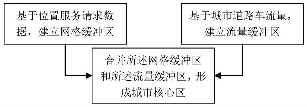
[0092] Such as figure 2 As shown, the method for determining the urban core area of ​​the present invention includes the following steps:

[0093] Establish grid buffer based on location service request data;

[0094] Establish a traffic buffer based on the traffic volume of urban roads;

[0095] The grid buffer zone and the traffic buffer zone are merged to form the urban core area.

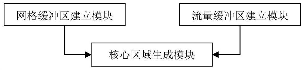
[0096] See image 3 , Which shows the detailed flowchart of the method for determining the urban core area of ​​the present invention, in which each operation step is listed. The method for determining the urban core area includes the following steps:

[0097] Data acquisition time range and update cycle setting steps. The location service request data and road traffic data of a region in a city within a time range...


PUM


Abstract

The invention relates to a method for determining an urban core area. The method comprises the following steps: establishing a grid buffer area based on position service request data; establishing a flow buffer area based on the urban road traffic flow; and combining the grid buffer area and the flow buffer area to form an urban core area. The method can overcome the difficulty that the urban corearea cannot be effectively divided and dynamically updated at present based on dynamic and static traffic data of vehicle-mounted navigation and electronic map manufacturers. Dynamic determination ofan urban core area is realized from two dimensions of urban positioning request heating power and a vehicle passing area through an internet technology and by applying a traffic big data analysis means. By establishing a unified determination standard, effective data support is provided for expansion and development trends of different cities in different periods, and a data foundation is laid for city development planning, traffic state evaluation and comprehensive prediction analysis.

Description

Technical field [0001] The invention relates to the fields of intelligent transportation, electronic maps, car navigation, urban planning and the like, and in particular to a determining method and device suitable for determining the core area of ​​a city. Background technique [0002] Administrative division is the abbreviation of administrative division, which is the division of regions implemented by the state for hierarchical management; the state is divided into administrative districts by region, and the administrative divisions of various countries have different divisions and names. Built-up area refers to the non-agricultural production and construction area developed through expropriated land and actual construction within the municipal administrative area. It includes the concentrated and contiguous parts of the urban area and the scattered in the suburbs. It is closely related to the city and has basically complete municipal utilities. Urban construction land for faci...

Claims


Application Information

Patent Timeline
IPC IPC(8): G06Q10/06G06Q50/26
CPCG06Q10/0639G06Q50/26
Inventor 王宇静房一多张青芳苏岳龙董振宁
Owner ALIBABA GRP HLDG LTD
Why Eureka
Eureka Blog
Learn More