
A Large-Scale Intertidal Vegetation Classification Method Based on Synthetic Aperture Radar

A synthetic aperture radar and intertidal zone technology, applied in the field of object recognition, can solve the problems of inability to accurately obtain large-scale surface vegetation coverage and differences in backscatter coefficients, and achieve accurate and reliable classification results, simple operation, The effect of improving the accuracy of classification

Active Publication Date: 2021-07-27
EAST CHINA NORMAL UNIV
View PDF0 Cites 0 Cited by
  • Summary
  • Abstract
  • Description
  • Claims
  • Application Information

AI Technical Summary

Problems solved by technology

[0005] The purpose of the present invention is to provide a large-scale intertidal zone vegetation classification method based on synthetic aperture radar in order to solve the current situation that the current remote sensing technology cannot accurately obtain the large-scale surface vegetation coverage in the intertidal zone vegetation classification. According to the differences in the backscatter coefficients of different vegetation types under different polarization modes, a set of intertidal vegetation classification system based on six characteristic spectral bands is proposed, which can be applied to large-scale vegetation classification in intertidal regions and improve classification precision and efficiency

Method used


Image

  • A Large-Scale Intertidal Vegetation Classification Method Based on Synthetic Aperture Radar
  • A Large-Scale Intertidal Vegetation Classification Method Based on Synthetic Aperture Radar
  • A Large-Scale Intertidal Vegetation Classification Method Based on Synthetic Aperture Radar

Examples


Embodiment Construction

[0029] In order to make the advantages, technical solutions and objectives of the present invention more accurate and clear so that those skilled in the art can realize the present invention, the present invention will be described below in conjunction with the drawings in the embodiments of the present invention. Obviously, the following embodiment is only an example of the present invention, and those of ordinary skill in the art can realize other obvious modifications based on this. Based on this embodiment, other modifications obtained by those of ordinary skill in the art without paying creative efforts Solutions, improved solutions, equivalent solutions and other technical solutions that do not depart from the scope of the present invention all belong to the protection scope of the present invention.

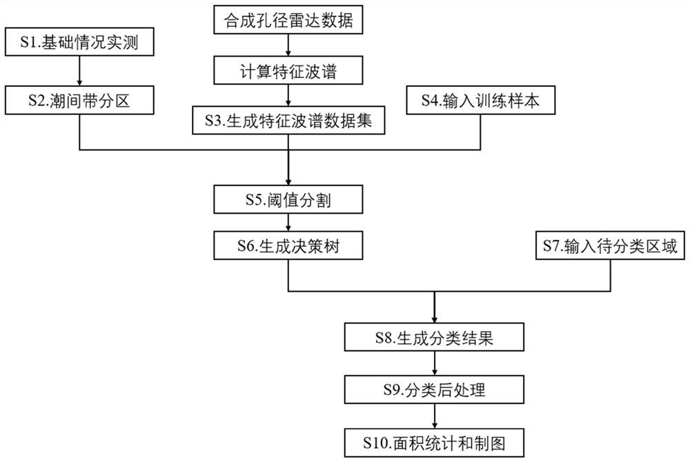
[0030] refer to figure 1 , the technical process of the embodiment of the present invention is clarified. Taking China's intertidal zone as an example, the present invent...


PUM


Abstract

The invention discloses a large-scale intertidal zone vegetation classification method based on synthetic aperture radar, comprising the following steps: measuring the basic conditions of the intertidal zone; subdividing the intertidal zone based on the investigation results of the basic condition of the intertidal zone Region division; generate characteristic spectral data sets, calculate new spectral segments based on original synthetic aperture radar data and synthesize data sets; input training samples, randomly and uniformly select several samples of different ground features; threshold segmentation, extract characteristic spectral data sets based on samples , select an appropriate threshold in the frequency distribution map to distinguish different regions; generate a decision tree, and build a large-scale intertidal vegetation classification system based on the threshold segmentation results of each region; input the region to be classified, and select the corresponding decision tree according to the input region models; generating classification results; post-classification processing; area statistics and cartography. Compared with the traditional small area classification method, the present invention has the advantages of small workload, simple operation, high efficiency, strong robustness and the like.

Description

technical field [0001] The invention relates to the field of object recognition using remote sensing technology, in particular to a large-scale intertidal zone vegetation classification method based on synthetic aperture radar. [0002] technical background [0003] The intertidal vegetation ecosystem is one of the most dynamic ecosystems in coastal areas. Under the background of sea level rise and intensified human activities, intertidal vegetation has undergone significant changes. Quickly grasping its spatial distribution characteristics can be used in many aspects such as blue carbon fixation, wave dissipation and slow flow, biodiversity maintenance, ecological protection, and scientific research. All are of great significance, and intertidal vegetation mapping is one of the important links. [0004] Due to the complex geological conditions and poor accessibility in the intertidal zone, the vegetation classification method based on field surveys cannot be carried out in ...

Claims


Application Information

Patent Timeline
Patent Type & Authority Patents(China)
IPC IPC(8): G06K9/00G06K9/62
CPCG06V20/188G06F18/24323
Inventor 胡越凯田波赵欣怡周云轩
Owner EAST CHINA NORMAL UNIV
Learn More