Check patentability & draft patents in minutes with Patsnap Eureka AI!

Regional terrain segmentation and digital elevation model acquisition method based on multi-source data

A digital elevation model, multi-source data technology, applied in image data processing, character and pattern recognition, 3D modeling, etc., can solve the problems of low degree of automation and large workload of manual processing.

Pending Publication Date: 2020-10-27
ZHEJIANG INST OF SURVEYING & MAPPING SCI & TECH
View PDF0 Cites 4 Cited by
  • Summary
  • Abstract
  • Description
  • Claims
  • Application Information

AI Technical Summary

Problems solved by technology

At present, the digital elevation model used for digital differential correction in the production of digital orthophotos is generally obtained by manual processing on the basis of historical digital elevation models or digital elevation models extracted and filtered according to uniform standard parameters. heavy processing workload

Method used


Image

  • Regional terrain segmentation and digital elevation model acquisition method based on multi-source data
  • Regional terrain segmentation and digital elevation model acquisition method based on multi-source data
  • Regional terrain segmentation and digital elevation model acquisition method based on multi-source data

Examples


Embodiment 1

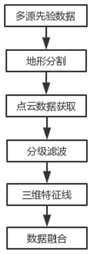
[0037] This embodiment is a method for regional terrain segmentation and digital elevation model acquisition based on multi-source data, such as figure 1 As shown, it mainly includes the following steps:

[0038] I: Terrain Segmentation

[0039] According to the terrain characteristics of the area, the terrain is divided into three levels: L 0 , L 1 , L 2 . L 0 The level represents the area where it is divided into flat areas, L 1 Level represents that the region is divided into mountainous regions, L 2 The area where the level representative is located is divided into the junction of Pingshan and Pingshan.

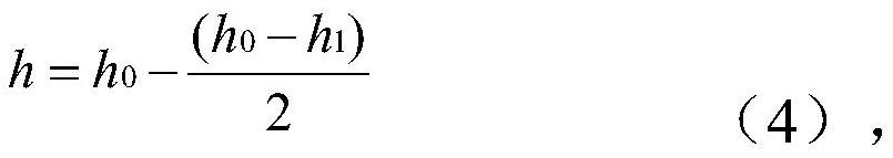
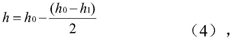
[0040] (1) L 0 The level is calculated by the slope correction formula,

[0041] i=2*h / l*100% (1)

[0042] like That is, the corresponding area is assigned to L 0 ;

[0043] Where h is the terrain height difference, l is the horizontal distance, and i is the calculated value of the slope.

[0044] (2) L 1 Level is reduced through the cluster analysis of th...


PUM


Abstract

The invention discloses a regional terrain segmentation and digital elevation model acquisition method based on multi-source data. The method comprises the following steps: carrying out the segmentation of a terrain, and forming a corresponding grade; acquiring digital surface models matched with the regions of different grades in a self-adaptive manner, and filtering the digital surface models; and fusing the results of different levels to obtain an initial digital elevation model which can be used for digital positive image production. The hierarchical digital elevation model is acquired byadopting a terrain segmentation method, and the digital elevation model is processed, so that the manual processing workload of the digital elevation model in the later period can be reduced to a great extent, and the automation degree of digital elevation model production and digital orthoimage production is improved.

Description

technical field [0001] The invention belongs to the technical field of digital orthophoto map generation, and in particular relates to a regional terrain segmentation and digital elevation model acquisition method based on multi-source data. Background technique [0002] The production of digital elevation models is one of the key technical processes in the production of digital orthophotos, and it is also a part of the manual intervention workload in the production of digital orthophotos. At present, the digital elevation model used for digital differential correction in the production of digital orthophotos is generally obtained by manual processing on the basis of historical digital elevation models or digital elevation models extracted and filtered according to uniform standard parameters. The processing workload is heavy. Contents of the invention [0003] The invention provides a regional terrain segmentation and digital elevation model acquisition method based on m...

Claims


Application Information

Patent Timeline
Patent Type & Authority Applications(China)
IPC IPC(8): G06T17/05G06T7/11G06T5/00G06K9/62
CPCG06T17/05G06T7/11G06T2207/10028G06F18/23G06T5/70Y02A90/10
Inventor 蔡志刚刘微微王艳高亚萍王琪陈文静左欢庆吴霞仙盛君
Owner ZHEJIANG INST OF SURVEYING & MAPPING SCI & TECH
Features
  • R&D
  • Intellectual Property
  • Life Sciences
  • Materials
  • Tech Scout
  • Unparalleled Data Quality
  • Higher Quality Content
  • 60% Fewer Hallucinations
Learn More