Sky-near-space cooperative remote sensing system and information transmission method thereof

A technology of remote sensing and ground systems, applied in the field of remote sensing systems, can solve problems such as the inability to meet the needs of emergency precise remote sensing monitoring

Active Publication Date: 2020-10-27
NAT INNOVATION INST OF DEFENSE TECH PLA ACAD OF MILITARY SCI
View PDF6 Cites 6 Cited by
  • Summary
  • Abstract
  • Description
  • Claims
  • Application Information

AI Technical Summary

Problems solved by technology

[0005] The existing remote sensing system only relies on single-domain remote sensing platforms or single-domain remote sensing formations, which cannot meet the needs of emergency and precise remote sensing monitoring; several domain platforms cooperate according to certain rules to independently obtain remote sensing data and build a collaborative remote sensing system. The scene has great limitations

Method used


Image

  • Sky-near-space cooperative remote sensing system and information transmission method thereof
  • Sky-near-space cooperative remote sensing system and information transmission method thereof

Examples


Embodiment Construction

[0036] In order to make the purpose, technical solution and advantages of the present invention clearer, the technical solution of the present invention will be clearly and completely described below in conjunction with specific embodiments of the present invention and corresponding drawings. Apparently, the described embodiments are only some of the embodiments of the present invention, but not all of them. Based on the embodiments of the present invention, all other embodiments obtained by persons of ordinary skill in the art without making creative efforts fall within the protection scope of the present invention.

[0037] The technical solutions provided by the embodiments of the present invention will be described in detail below in conjunction with the accompanying drawings.

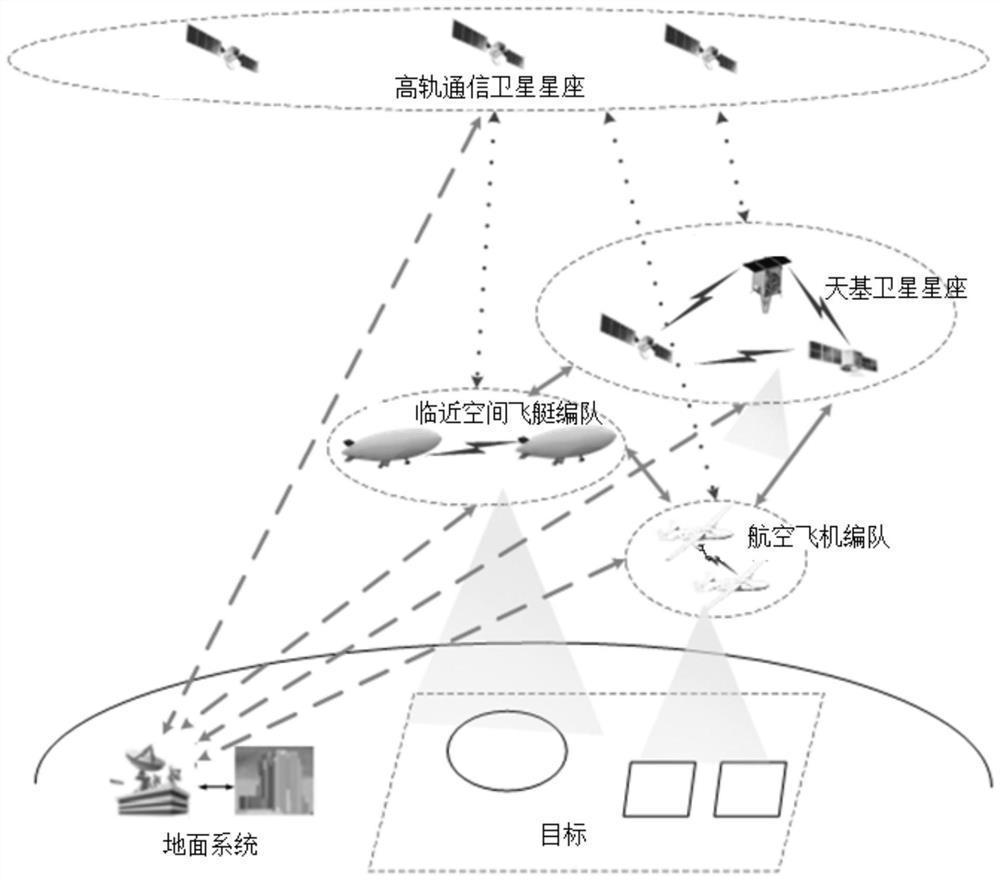
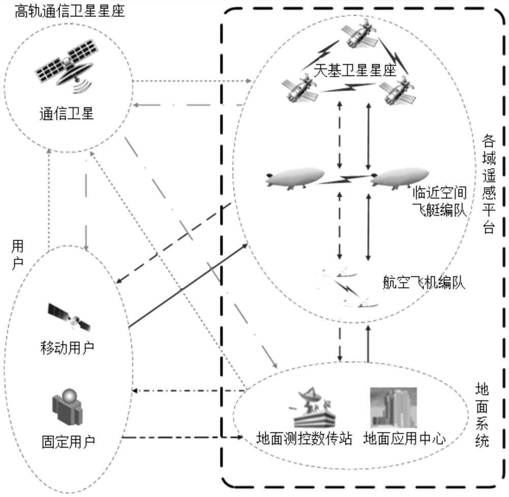
[0038] as attached Figure 1-2As shown, an embodiment of the present invention provides a collaborative remote sensing system between the sky and the sky. The collaborative remote sensing system b...


PUM


Abstract

The invention discloses a sky-near-space cooperative remote sensing system and an information transmission method thereof. The system comprises a high-orbit communication satellite constellation, alldomain remote sensing platforms and a ground system. The high-orbit communication satellite constellation is in communication connection with each domain remote sensing platform, the ground system anda user; each domain remote sensing platform comprises a space-based satellite constellation, a near space airship formation and an aviation aircraft formation which are in communication connection with one another and is used for acquiring remote sensing data; and the ground system is in communication connection with the high-orbit communication satellite constellation, each domain remote sensingplatforms and the user and is used for processing user services and remote sensing data and controlling and managing the high-orbit communication satellite constellation and each domainremote sensingplatform. According to the sky-near-space cooperative remote sensing system and the information transmission method thereof, the large-range, long-time, refined and high-efficiency remote sensing requirements under daily and rapid application requirements can be effectively met, and the sky-near-space cooperative remote sensing system and the information transmission method thereof can be widelyapplied to various monitoring tasks such as resource investigation, natural disaster observation, major activity monitoring and anti-terrorism stability maintenance monitoring.

Description

technical field [0001] The invention relates to the technical field of remote sensing systems, in particular to a sky-link-air collaborative remote sensing system and an information transmission method thereof. Background technique [0002] With the development of remote sensing technology, the remote sensing system has changed from a single remote sensing platform to a remote sensing formation to improve the coverage, observation time and positioning accuracy of the remote sensing system. A single remote sensing platform is, for example, a remote sensing satellite, a remote sensing airship or a remote sensing The aircraft and the remote sensing formation are, for example, remote sensing satellite constellations, remote sensing airship formations, or remote sensing aircraft formations. However, when performing complex monitoring tasks, such as natural disasters, major activities, and violent terrorist incidents, the remote sensing system used to perform tasks is required to ...

Claims


Application Information

Patent Timeline
Patent Type & Authority Applications(China)
IPC IPC(8): H04B7/185G01S13/90
CPCG01S13/90H04B7/18513H04B7/18515H04B7/18517
Inventor 郭鹏宇
Owner NAT INNOVATION INST OF DEFENSE TECH PLA ACAD OF MILITARY SCI
Why Eureka
Try Eureka