A method, system and device for spatial-temporal fusion of remote sensing image data

A remote sensing image, spatiotemporal fusion technology, applied in the field of remote sensing, can solve problems such as the inability to guarantee the robustness and reliability of accurate prediction, the large difference in results, and the inability to judge the reliability of the fusion image.

Active Publication Date: 2021-09-21
THE HONG KONG POLYTECHNIC UNIV SHENZHEN RES INST
View PDF16 Cites 0 Cited by
  • Summary
  • Abstract
  • Description
  • Claims
  • Application Information

AI Technical Summary

Problems solved by technology

[0003] 1) Most of the existing spatio-temporal fusion algorithms are based on the assumption that the types of ground objects do not change between two periods of time. Therefore, most algorithms often fail in the face of changes in the types of ground objects. The lack of a judgment mechanism for changes in the types of ground objects limits space-time fusion. The application scenarios of the algorithm, the reliability of the fused image cannot be judged in practical applications
[0004] 2) The current space-time fusion algorithm faces three different types of surface landscapes: heterogeneous, abrupt, and homogeneous. The results obtained by using different space-time fusion algorithms are very different, which cannot guarantee robustness and reliability. Accurately predict remote sensing images in all scenarios

Method used


Image

  • A method, system and device for spatial-temporal fusion of remote sensing image data
  • A method, system and device for spatial-temporal fusion of remote sensing image data
  • A method, system and device for spatial-temporal fusion of remote sensing image data

Examples


Embodiment Construction

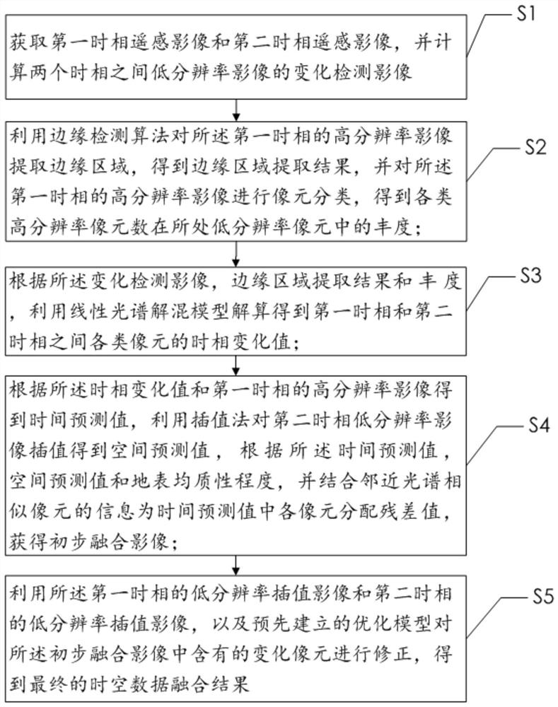
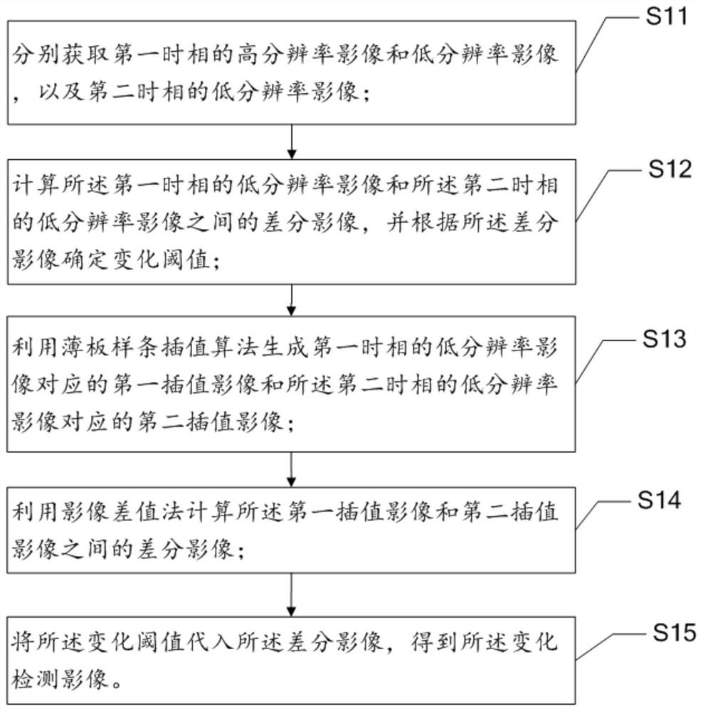
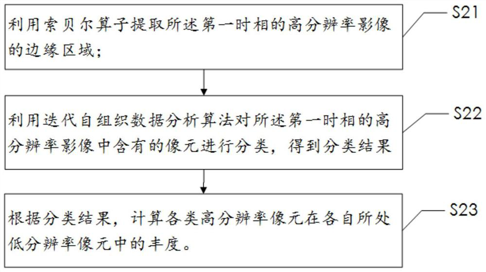
[0056] In order to make the object, technical solution and advantages of the present invention more clear and definite, the present invention will be further described in detail below with reference to the accompanying drawings and examples. It should be understood that the specific embodiments described here are only used to explain the present invention, not to limit the present invention.

[0057] Those skilled in the art will understand that unless otherwise stated, the singular forms "a", "an", "said" and "the" used herein may also include plural forms. It should be further understood that the word "comprising" used in the description of the present invention refers to the presence of said features, integers, steps, operations, elements and / or components, but does not exclude the presence or addition of one or more other features, Integers, steps, operations, elements, components, and / or groups thereof. It will be understood that when an element is referred to as being "...


PUM


Abstract

The present invention proposes a method, system and equipment for spatio-temporal fusion of remote sensing image data. Change detection images are obtained by computing low-resolution remote sensing images in two time phases; the edge area of ​​the high-resolution image in the first phase is extracted, and each The abundance corresponding to the number of high-resolution pixels; calculate the time-phase change value of various pixels according to the extraction results and abundance of the edge area; calculate the time prediction value and spatial prediction value; according to the degree of surface homogeneity, time prediction Values ​​and spatial prediction values, combined with neighborhood information to assign residual values ​​to obtain a preliminary fusion image; use the established optimization model to correct the changing pixels contained in the preliminary fusion image, and obtain the spatio-temporal data fusion result. The method described in this embodiment comprehensively considers the applicability of different change detection algorithms in different scenarios, improves the overall spectral accuracy of fusion and retains more spatial detail information, and can obtain better spatio-temporal data fusion results.

Description

technical field [0001] The invention relates to the technical field of remote sensing, in particular to a method, system and equipment for spatio-temporal fusion of remote sensing image data. Background technique [0002] Obtaining high temporal and spatial resolution remote sensing images is of great significance to intensive time series surface observation research. Existing spatio-temporal fusion methods have their own advantages and problems, among which there are two typical problems: [0003] 1) Most of the existing spatio-temporal fusion algorithms are based on the assumption that the types of ground objects do not change between two periods, so most of the algorithms often fail in the face of changes in the types of ground objects, and the lack of a judgment mechanism for changes in the types of ground objects limits spatio-temporal fusion The application scenarios of the algorithm cannot judge the reliability of the fused image in practical applications. [0004] ...

Claims


Application Information

Patent Timeline
Patent Type & Authority Patents(China)
IPC IPC(8): G06T5/50G06T7/00G06T7/11G06T7/12G06K9/62
CPCG06T5/50G06T7/0002G06T7/12G06T7/11G06T2207/10032G06T2207/20221G06F18/22G06F18/24
Inventor 史文中郭迪洲
Owner THE HONG KONG POLYTECHNIC UNIV SHENZHEN RES INST
Why Eureka
Try Eureka