Full-path compensation primary wave and multiple wave combined imaging method in deep sea environment

A deep-sea environment and imaging method technology, applied in the field of marine geophysical exploration, can solve problems such as seismic wave attenuation, low-resolution shadow areas, and poor imaging accuracy

Active Publication Date: 2020-12-15
CHINA UNIV OF PETROLEUM (EAST CHINA)
View PDF4 Cites 1 Cited by
  • Summary
  • Abstract
  • Description
  • Claims
  • Application Information

AI Technical Summary

Problems solved by technology

[0004] In order to overcome the problem of severe attenuation of seismic waves in the marine environment and solve the problems of low-resolution shadow areas and poor imaging accuracy in the traditional imaging process, the present inventi

Method used


Image

  • Full-path compensation primary wave and multiple wave combined imaging method in deep sea environment
  • Full-path compensation primary wave and multiple wave combined imaging method in deep sea environment
  • Full-path compensation primary wave and multiple wave combined imaging method in deep sea environment

Examples


Embodiment Construction

[0091] Below in conjunction with accompanying drawing and specific embodiment the present invention is described in further detail:

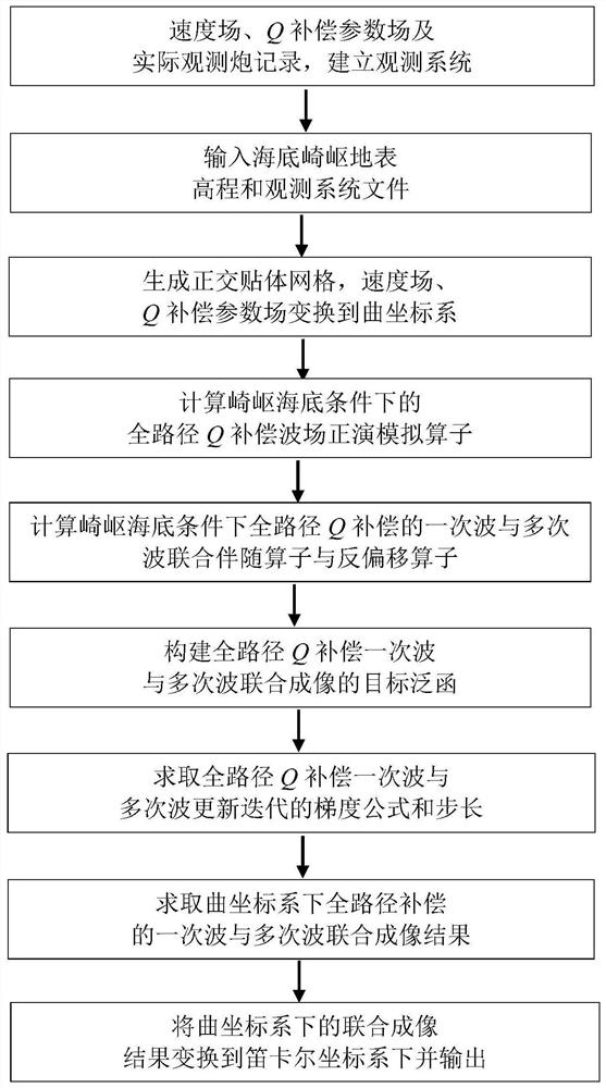
[0092] The present invention proposes a combined imaging method for full-path compensation of primary and multiple waves in a deep-sea environment, such as figure 1 As shown, it specifically includes the following steps:

[0093] Step 1: Input the velocity field, Q compensation parameter field and actual observation shot records to establish the observation system.

[0094] Step 2: Input the seabed rough surface elevation and observation system file.

[0095] Step 3: Generate an orthogonal body-fitted grid according to the rough surface elevation of the seabed, and transform the velocity field and Q compensation parameter field into a curved coordinate system.

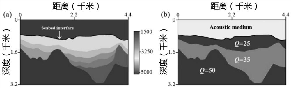
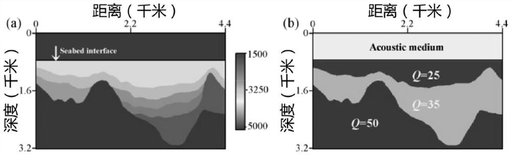
[0096] Step 4: Based on the characteristics of the deep-sea environment, use acoustic medium for wave field continuation in the upper seawater area, and viscoacoustic medium for the me...


PUM


Abstract

The invention discloses a full-path compensation primary wave and multiple wave combined imaging method in a deep sea environment, and particularly relates to the field of marine geophysical exploration. The method comprises the following steps: establishing an observation system by inputting a speed field, a Q compensation parameter field and an actual observation gun record, inputting a seabed rugged surface elevation and an observation system file, generating an orthogonal skin grid, and converting the speed field and the Q compensation parameter field into a curved coordinate system; calculating a forward modeling operator, a primary wave and multiple wave joint accompanying operator and a demigration operator of a full-path Q compensation wave field under a rugged seabed condition based on deep sea environment characteristics, constructing a target functional of full-path Q compensation primary wave and multiple wave joint imaging, and solving a gradient; and calculating a full-path compensation primary wave and multiple wave combined imaging result under a curved coordinate system, converting the result into a Cartesian coordinate system, and outputting an imaging result. Theinfluence of the fluctuating seabed surface is eliminated, the primary wave and multiple wave information is fully utilized, and the imaging precision in the deep sea environment is improved.

Description

technical field [0001] The invention belongs to the field of marine geophysical exploration, and in particular relates to a combined imaging method for full-path compensation of primary waves and multiple waves in a deep sea environment. Background technique [0002] The geophysical exploration environment in the marine environment is relatively complex, the upper half is the seawater medium, and the lower half is the submarine subsurface medium, so the seismic wave attenuation and absorption phenomenon in the marine environment is also more complicated, and the double complex medium in the deep sea environment gives conventional seismic imaging This brings great difficulties. Conventional seismic exploration uses reflected waves for imaging. Due to the absorption and attenuation of the medium during the propagation of seismic waves, the imaging effect of seismic waves in the deep sea environment is greatly reduced, especially the imaging effect of the target layer under the ...

Claims


Application Information

Patent Timeline
IPC IPC(8): G01V1/36G01V1/30
CPCG01V1/362G01V1/301G01V2210/53G01V2210/40
Inventor 曲英铭黄建平李振春符力耘刘畅黄崇棚
Owner CHINA UNIV OF PETROLEUM (EAST CHINA)
Why Eureka
Try Eureka