Fusion method for generating high-spatial-resolution multispectral image

A high spatial resolution, multispectral image technology, applied in the field of spatial spectrum fusion of remote sensing data, can solve the problem of not considering fusion images and so on

Active Publication Date: 2020-12-18
BEIJING NORMAL UNIVERSITY
View PDF12 Cites 1 Cited by
  • Summary
  • Abstract
  • Description
  • Claims
  • Application Information

AI Technical Summary

Problems solved by technology

However, none of them considers the ability to generate high-precision fusion

Method used


Image

  • Fusion method for generating high-spatial-resolution multispectral image
  • Fusion method for generating high-spatial-resolution multispectral image
  • Fusion method for generating high-spatial-resolution multispectral image

Examples


Embodiment Construction

[0054] In order to have a clearer understanding of the technical features, purposes and effects of the present invention, the specific implementation manners of the present invention will now be described with reference to the accompanying drawings. But those skilled in the art should know that the following examples are not the sole limitation to the technical solution of the present invention, and any equivalent transformation or modification made under the spirit of the technical solution of the present invention should be considered as belonging to the protection of the present invention scope.

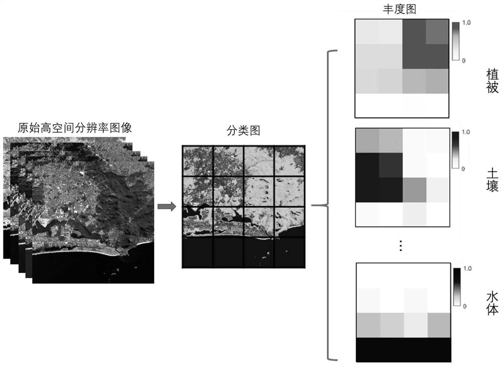
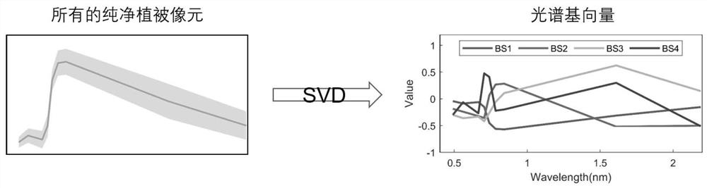
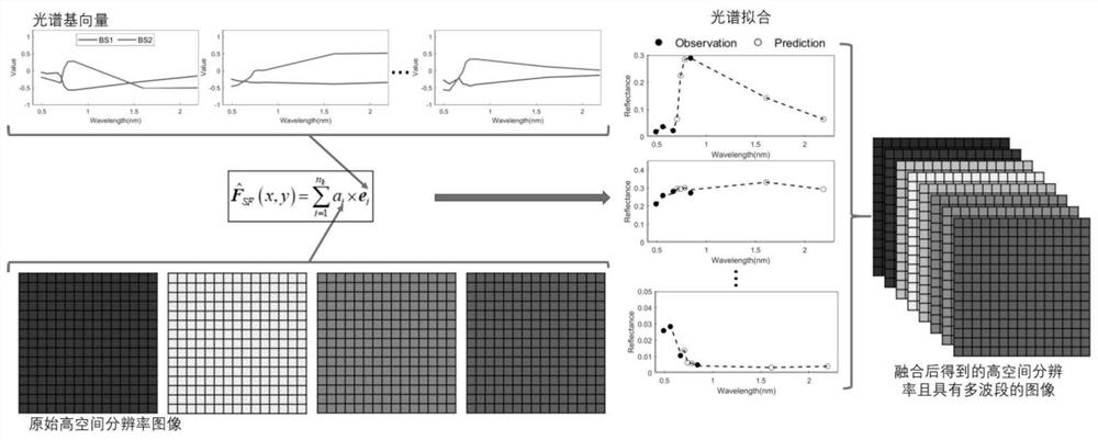
[0055] The fusion method for generating high-spatial-resolution multi-spectral images of the present invention is described in detail below. The method is based on the principle of spectral fitting to produce high-spatial-resolution images with multiple bands. The same as the method for fusion of type data, the present invention is also a method for fusion of remote sensing data f...


PUM


Abstract

The invention provides a fusion method for generating a high-spatial-resolution multispectral image, which is used for fusing an image with high spatial resolution and less spectral bands and an imagewith low spatial resolution and more spectral bands to generate an image with high spatial resolution and multispectral bands, and comprises the following steps of: generating an image with high spatial resolution and multispectral bands, and comprises the steps of: extracting a spectrum base from the image with low spatial resolution; comparing the existing wave band of the high-spatial-resolution image with the reconstructed wave band, and resolving to obtain a coefficient corresponding to the spectrum base; and reconstructing all spectrums of the high-spatial-resolution pixels through linear combination of the spectrum bases and the corresponding coefficients of the spectrum bases, so that an image with high spatial resolution and multispectral bands is generated. According to the fusion method for generating the high-spatial-resolution multispectral image, the advantages of the two images can be combined on the basis of spectral fitting, the spectral similarity between geographicdata is fully utilized, and an effective method is provided for producing the high-spatial-resolution multiband image.

Description

technical field [0001] The invention relates to a multi-source remote sensing data fusion method, which is used for generating high-spatial-resolution multi-spectral remote sensing images, and belongs to the space-spectrum fusion category of remote sensing data. Background technique [0002] With the development of satellite sensors, imagery with a spatial resolution of less than 5 meters has been widely used in the past few decades. The improved spatial resolution of such images provides richer spatial details of the land surface, facilitating many successful applications such as urban land cover / use classification, change detection, and object recognition, among others. Unfortunately, due to budgetary and technical constraints, such high-spatial-resolution images usually have limited spectral bands, mainly in the visible and near-infrared (VNIR) bands. The shortage of important spectral bands such as the red edge and short-wave infrared (SWIR) bands greatly limits the wid...

Claims


Application Information

Patent Timeline
IPC IPC(8): G06T5/50G06T7/90G06T3/40G06K9/62
CPCG06T5/50G06T7/90G06T3/4053G06T2207/10032G06T2207/10048G06T2207/30181G06F18/24Y02A90/10
Inventor 陈晋周俊雄陈学泓曹鑫崔喜红
Owner BEIJING NORMAL UNIVERSITY
Why Eureka
Try Eureka