Navigation interface display method and device, computing equipment and storage medium

A technology of interface display and display area, applied in the computer field, can solve the problems of affecting the acquisition rate of enlarged images, affecting the navigation experience, multi-flow, etc., and achieve the effect of improving user navigation experience, reducing yaw rate, and improving efficiency

Active Publication Date: 2020-12-18
TENCENT TECH (SHENZHEN) CO LTD
View PDF17 Cites 4 Cited by
  • Summary
  • Abstract
  • Description
  • Claims
  • Application Information

AI Technical Summary

Problems solved by technology

Therefore, the delivery process of these two kinds of enlarged images needs to consume more traffic, and has higher requirements on network bandwidth.
This may affect the acquisition rate of the enlarged image during the actual navigation process, and thus affect the navigation experience

Method used


Image

  • Navigation interface display method and device, computing equipment and storage medium
  • Navigation interface display method and device, computing equipment and storage medium
  • Navigation interface display method and device, computing equipment and storage medium

Examples


Embodiment Construction

[0035] Before introducing the embodiments of the present invention in detail, some related concepts are firstly explained:

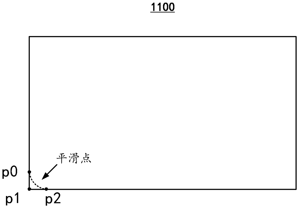
[0036] 1. Vectorized data: A data organization method that uses Euclidean geometry points, lines, surfaces and their combinations to represent the spatial distribution of geographic entities. Taking two-dimensional space as an example, in vectorized data, a point entity can be represented by a pair of coordinates, a line entity can be considered as a curve composed of continuous straight line segments, and can be represented by a series of coordinate pairs, and a surface entity can be represented by indicated by its boundary line.

[0037] 2. Pipeline model: The pipeline model mentioned in the present invention is a three-dimensional model that can be used to simulate road network elements that are parallel to the road centerline, such as double yellow lines, lane lines, and curbs.

[0038] 3. FOV (Field of View): The angle of view, with the observation...


PUM


Abstract

The embodiment of the invention relates to a navigation interface display method and device, computing equipment and a computer readable storage medium. The navigation interface display method comprises the following steps: obtaining vectorized data, wherein the vectorized data is used for carrying out three-dimensional modeling on an intersection; establishing a three-dimensional vector model ofthe intersection by utilizing the vectorized data; generating a three-dimensional vector enlarged drawing of the intersection based on the three-dimensional vector model; and displaying the three-dimensional vector magnified image in an intersection display area on the navigation interface. According to the embodiment of the invention, the data volume required for generating the intersection enlarged map is reduced, and the maintenance efficiency of the navigation data of the electronic map is improved.

Description

technical field [0001] The present invention relates to the field of computer technology, in particular to a navigation interface display method, device, computing equipment and computer-readable storage medium. Background technique [0002] A navigation app is a product that provides route guidance services to users while they are walking or driving. At present, mainstream navigation applications can usually provide enlarged images of intersections, so that users can see the information of the intersection area more clearly, so as to avoid traveling to the wrong road or direction. However, the magnified intersection images provided by the current navigation applications mainly include real-scene magnified images and mode magnified images. The production costs of these two types of enlarged maps are high, and the mapping process relies heavily on manual labor, so it is difficult to have the ability to cover large-scale intersections. Furthermore, both amplified Figure 1 G...

Claims


Application Information

Patent Timeline
Patent Type & Authority Applications(China)
IPC IPC(8): G06T17/05G06T17/20G06T15/00G06F16/29
CPCG06T17/05G06T17/20G06T15/00G06F16/29
Inventor 唐博
Owner TENCENT TECH (SHENZHEN) CO LTD
Why Eureka
Try Eureka