Airport target identification method and device based on satellite images

A satellite image and target recognition technology, applied in the field of image processing, can solve problems such as uneven camera optical space response, inaccurate airport target outline, satellite image stripe or band radiation difference, etc.

Active Publication Date: 2021-01-29
DAODATIANJI SOFTWARE TECH BEIJING
View PDF6 Cites 6 Cited by
  • Summary
  • Abstract
  • Description
  • Claims
  • Application Information

AI Technical Summary

Problems solved by technology

[0003] In the prior art, because the satellite images used for airport target recognition are easily affected by factors such as uneven optical spatial response of the camera and different responses of each pixel during the imaging process, the acquired satellite images often have obvious stripes or bands. radiation discrepancy phenomenon that makes the outlines of airport objects identified from satellite imagery imprecise

Method used


Image

  • Airport target identification method and device based on satellite images
  • Airport target identification method and device based on satellite images
  • Airport target identification method and device based on satellite images

Examples


Embodiment Construction

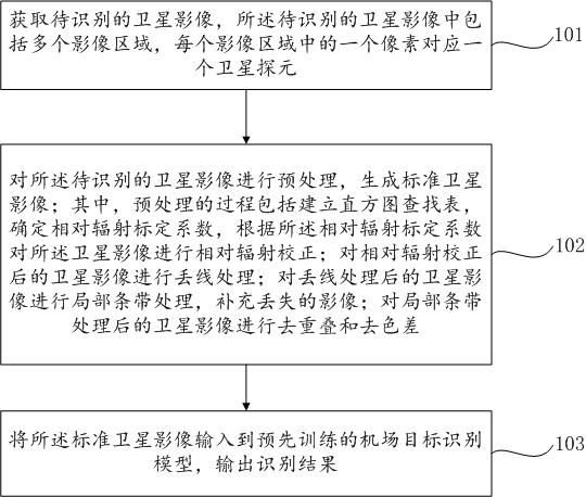
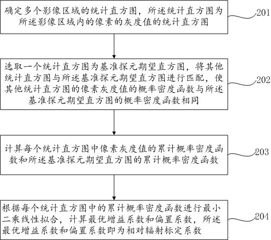
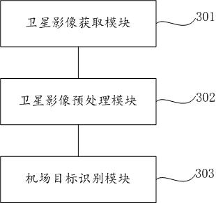
[0065] In order to make the purpose, technical solutions and advantages of the embodiments of the present disclosure clearer, the technical solutions in the embodiments of the present disclosure will be clearly and completely described below in conjunction with the drawings in the embodiments of the present disclosure. Obviously, the described embodiments It is a part of the embodiments of the present disclosure, but not all of them. Based on the embodiments in the present disclosure, all other embodiments obtained by persons of ordinary skill in the art without making creative efforts belong to the protection scope of the present disclosure.

[0066] In addition, the term "and / or" in this article is only an association relationship describing associated objects, indicating that there may be three relationships, for example, A and / or B may indicate: A exists alone, A and B exist simultaneously, There are three cases of B alone. In addition, the character " / " in this article g...


PUM


Abstract

The invention provides an airport target identification method and device based on satellite images. The method comprises the following steps: acquiring a to-be-identified satellite image; preprocessing the satellite image to be identified to generate a standard satellite image, the preprocessing process comprising establishing a histogram lookup table, determining a relative radiation calibrationcoefficient, and performing relative radiation correction on the satellite image according to the relative radiation calibration coefficient; performing line loss processing on the satellite image after relative radiation correction; carrying out local stripe processing on the satellite image after line loss processing, and supplementing the lost image; de-overlapping and de-chromatic aberrationare carried out on the satellite image after local stripe processing; and inputting the standard satellite image into a pre-trained airport target identification model, and outputting an identification result. In this way, the airport target in the satellite image can be accurately recognized.

Description

technical field [0001] Embodiments of the present disclosure generally relate to the technical field of image processing, and more specifically, relate to a method and device for identifying airport targets based on satellite images. Background technique [0002] As an important means of transportation and military facilities, airports play a very important role in various fields, especially basic information, aviation security, and national defense construction. Therefore, it is very important to quickly and accurately identify and locate airports from massive remote sensing images. significance. Traditional remote sensing image target detection methods are generally divided into three steps: one is region search, the other is feature extraction, and the third is classifier judgment. There are two main types of methods. One is based on the gray feature of the image, and determines the suspected area of ​​the airport through image segmentation or visual saliency mechanism. ...

Claims


Application Information

Patent Timeline
Patent Type & Authority Applications(China)
IPC IPC(8): G06K9/00G06N3/08
CPCG06N3/08G06V20/13
Inventor 严华王慧静杨晓冬杨斌张丽莎
Owner DAODATIANJI SOFTWARE TECH BEIJING
Why Eureka
Try Eureka