Method and system for generating two-dimensional map with obstacle three-dimensional information and terminal

A two-dimensional map and three-dimensional information technology, which is applied in radio wave measurement systems, electromagnetic wave re-radiation, instruments, etc., can solve the problem of reduced efficiency of dynamic obstacle avoidance, inability to obtain obstacle boundary information and spatial information, and obstacle avoidance accuracy. Low-level problems to achieve the effect of improving dynamic obstacle avoidance

Pending Publication Date: 2021-02-05
SHENZHEN HUA XIN INFORMATION TECH CO LTD
View PDF5 Cites 6 Cited by
  • Summary
  • Abstract
  • Description
  • Claims
  • Application Information

AI Technical Summary

Problems solved by technology

[0003] In view of the shortcomings of the prior art described above, the purpose of the present invention is to provide a two-dimensional map generation method, system and terminal with three-dimensional information of obstacles, which is used to solve the problem that mobile devices such as robots in the prior art only use single-line laser radar. When constructing a map, the laser can only scan the two-dimensional information of the plane where the laser head is located, and cannot obtain all the information of the object, and cannot obtain the boundary information and spatial information of obstacles, resulting in low accuracy of obstacle avoidance and reduced work efficiency of dynamic obstacle avoidance The problem

Method used


Image

  • Method and system for generating two-dimensional map with obstacle three-dimensional information and terminal
  • Method and system for generating two-dimensional map with obstacle three-dimensional information and terminal
  • Method and system for generating two-dimensional map with obstacle three-dimensional information and terminal

Examples


specific Embodiment

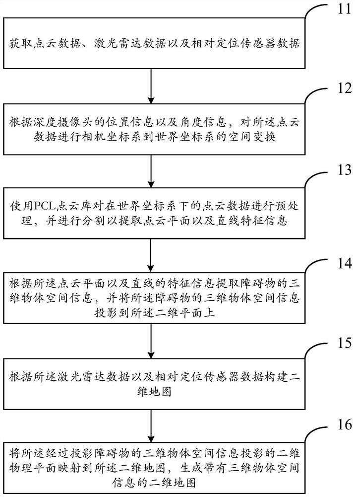
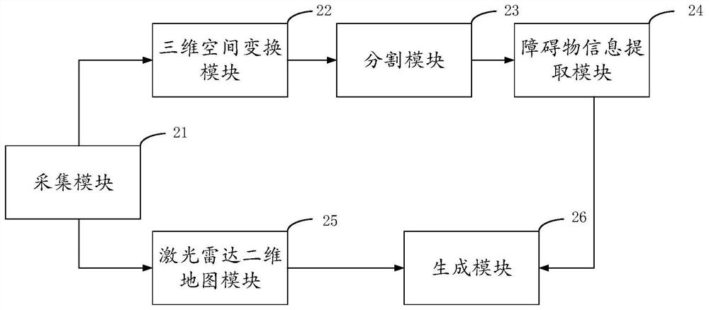
[0055] Such as figure 2 Shown is a schematic structural diagram of a two-dimensional map generation system with three-dimensional information of obstacles in an embodiment of the present invention.

[0056] Acquisition module 21, is used for obtaining point cloud data, lidar data and relative positioning sensor data;

[0057] The three-dimensional space transformation module 22, connected to the acquisition module 21, is used to perform three-dimensional space transformation on the point cloud data according to the position information and angle information installed by the depth camera, and the position information of the current frame of the robot to obtain the coordinates in the world. The point cloud data under the system;

[0058] The segmentation module 23 is connected to the three-dimensional space transformation module 22, and is used to preprocess the point cloud data in the world coordinate system using the PCL point cloud library, and perform segmentation to extra...


PUM


Abstract

The invention provides a method and system for generating a two-dimensional map with obstacle three-dimensional information and a terminal, and solves problems that in the prior art, when a robot andother mobile equipment only use a single-line laser radar to construct a map, laser can only acquire two-dimensional plane information within a laser head scanning radius range, three-dimensional structure information of an object cannot be acquired, and the boundary information and the space information of the obstacle cannot be obtained, and thus the obstacle avoidance accuracy is low, and the working efficiency of dynamic obstacle avoidance is reduced. According to the invention, the depth camera and the single-line laser radar are combined, generated three-dimensional information is projected to a two-dimensional plane and fused into a map constructed by the laser radar, boundary information and space information of obstacles can be effectively obtained on the map, and effects of dynamic obstacle avoidance and path planning and other functions of mobile equipment such as a robot is effectively improved.

Description

technical field [0001] The invention relates to the field of artificial intelligence, in particular to a method, system and terminal for generating a two-dimensional map with three-dimensional information of obstacles. Background technique [0002] At this stage, when only single-line lidar is used for map construction, the laser can only collect two-dimensional plane information within the scanning radius of the laser head, and cannot obtain all information of objects, and cannot obtain boundary information and spatial information of obstacles. Especially for mobile devices such as robots, only using lidar for map construction will lead to low accuracy of obstacle avoidance and reduced work efficiency of dynamic obstacle avoidance. Contents of the invention [0003] In view of the shortcomings of the prior art described above, the purpose of the present invention is to provide a two-dimensional map generation method, system and terminal with three-dimensional information ...

Claims


Application Information

Patent Timeline
Patent Type & Authority Applications(China)
IPC IPC(8): G01S17/89G01S17/931G01S17/86
CPCG01S17/89G01S17/931G01S17/86
Inventor 李会川
Owner SHENZHEN HUA XIN INFORMATION TECH CO LTD
Why Eureka
Try Eureka