Road identification method and device based on elevated road, computer equipment and storage medium

A technology of road identification and road sections, applied in the computer field, can solve problems such as inaccurate current position positioning and inaccurate routes

Active Publication Date: 2021-02-19
TENCENT TECH (SHENZHEN) CO LTD
View PDF5 Cites 1 Cited by
  • Summary
  • Abstract
  • Description
  • Claims
  • Application Information

AI Technical Summary

Problems solved by technology

However, route planning and navigation need to locate the current location. If the location of the current location is inaccurate, the planned route will not be accurate.
[0003] In the existing electronic map data, there are very few road data and road data on the viaduct in the electronic map. When the route planning and navigation involve the road on the viaduct or the road under the bridge, the positioning of the current position not accurate

Method used


Image

  • Road identification method and device based on elevated road, computer equipment and storage medium
  • Road identification method and device based on elevated road, computer equipment and storage medium
  • Road identification method and device based on elevated road, computer equipment and storage medium

Examples


Embodiment Construction

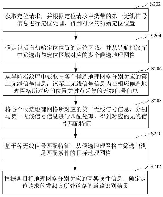
[0065] In order to make the purpose, technical solution and advantages of the present application clearer, the present application will be further described in detail below in conjunction with the accompanying drawings and embodiments. It should be understood that the specific embodiments described here are only used to explain the present application, and are not intended to limit the present application.

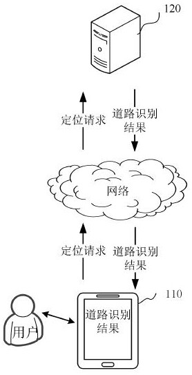
[0066] The elevated road identification method provided by this application can be applied to such as figure 1 The road recognition system shown. Such as figure 1 As shown, the road recognition system includes a terminal 110 and a server 120 . In one embodiment, both the terminal 110 and the server 120 can independently execute the elevated-based road identification method provided in the embodiment of the present application. The terminal 110 and the server 120 can also be used in cooperation to implement the elevated-based road identification method provided in the em...


PUM


Abstract

The invention relates to an elevated road identification method and device, computer equipment and a storage medium. The method comprises the following steps: positioning according to first wireless signal information in a positioning request to obtain an initial positioning position, screening candidate geographic grids corresponding to the positioning area including the initial positioning position from a navigation fingerprint library,acquiring second wireless signal information of each candidate geographic grid, wherein the second wireless signal information is acquired at a position key point corresponding to the candidate geographic grid, based on wireless signal matching characteristics obtained by matching the second wireless signal information corresponding to each candidate geographic grid with the first wireless signal information, screening out a target geographic grid meeting a matching condition from the candidate geographic grids, and determining a road identification result of the road where the initiator of the positioning request is located according to the elevated attribute information corresponding to each target geographic grid. The method can accurately identify whether the road where the user is located is the elevated upper side road or the elevated lower side road, and can be used for map navigation.

Description

technical field [0001] The present application relates to the field of computer technology, in particular to an elevated-based road identification method, device, computer equipment and storage medium. Background technique [0002] With the development of computer technology, the functions of electronic maps are becoming more and more comprehensive. People can use electronic maps to find destinations, plan walking routes, plan vehicle routes, and real-time navigation. However, route planning and navigation need to locate the current position. If the current position is not accurately located, the planned route will not be accurate. [0003] In the existing electronic map data, there are very few road data on the viaduct and the road under the bridge in the electronic map. When the route planning and navigation involve the road on the viaduct or the road under the bridge, the positioning of the current position is very difficult. Not exactly. Contents of the invention [...

Claims


Application Information

Patent Timeline
Patent Type & Authority Applications(China)
IPC IPC(8): G06K9/00G06K9/62G06T17/05G06F16/29H04W4/024G01S19/42
CPCG06T17/05G06F16/29H04W4/024G01S19/42G06V20/182G06F2218/00G06F18/22
Inventor 倪嘉志李欣
Owner TENCENT TECH (SHENZHEN) CO LTD
Why Eureka
Try Eureka