Fine Extraction Method of Remote Sensing Image Information Based on Surface Elements

A remote sensing image and extraction method technology, applied in the field of satellite remote sensing image extraction, can solve the problem of low extraction accuracy of surface elements, and achieve the effects of avoiding high cost investment, easy acquisition, and improving extraction accuracy

Active Publication Date: 2021-05-28
AEROSPACE INFORMATION RES INST CAS
View PDF2 Cites 0 Cited by
  • Summary
  • Abstract
  • Description
  • Claims
  • Application Information

AI Technical Summary

Problems solved by technology

[0003] Aiming at the above-mentioned technical problems in related technologies, the present invention proposes a method for finely extracting remote sensing image information based on surface elements, which can solve the technical problem that the extraction accuracy of surface elements by traditional object-oriented classification features is not high

Method used


Image

  • Fine Extraction Method of Remote Sensing Image Information Based on Surface Elements
  • Fine Extraction Method of Remote Sensing Image Information Based on Surface Elements
  • Fine Extraction Method of Remote Sensing Image Information Based on Surface Elements

Examples


Embodiment Construction

[0036] The following will clearly and completely describe the technical solutions in the embodiments of the present invention with reference to the accompanying drawings in the embodiments of the present invention. Obviously, the described embodiments are only some, not all, embodiments of the present invention. All other embodiments obtained by persons of ordinary skill in the art based on the embodiments of the present invention belong to the protection scope of the present invention.

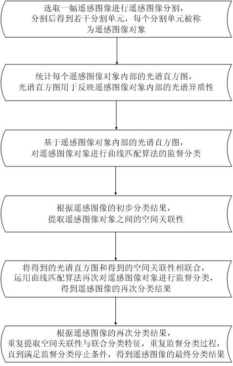
[0037] As shown in Figure 1, according to the fine extraction method of remote sensing image information based on surface elements described in the embodiment of the present invention, this method takes into account the spectral heterogeneity inside the remote sensing image object and the spatial correlation between remote sensing image objects, and can It accurately extracts surface elements from high-resolution remote sensing images, and belongs to an object-based remote sensing image classi...


PUM


Abstract

The invention discloses a method for finely extracting remote sensing image information based on surface elements. The method includes: selecting a high-resolution remote sensing image for remote sensing image segmentation, and obtaining several segmentation units after segmentation, and each segmentation unit is called a remote sensing image object; count the spectral histogram inside each remote sensing image object, and the spectral histogram is used as the first classification feature of the remote sensing image object; based on the internal spectral histogram of the remote sensing image object, perform the supervised classification of the curve matching algorithm on the remote sensing image object; according to For the preliminary classification results of remote sensing images, record the category numbers of the preliminary classification results for several adjacent remote sensing image objects in four directions for each remote sensing image object, and extract the spatial correlation between remote sensing image objects, and the spatial correlation is taken as The second classification feature of remote sensing image objects; combine the spectral histogram and spatial correlation, and use the curve matching algorithm to supervise the classification of remote sensing image objects again.

Description

technical field [0001] The invention relates to the technical field of satellite remote sensing image extraction, in particular to a method for finely extracting remote sensing image information based on surface elements. Background technique [0002] The popularization of high-resolution remote sensing images provides a basis for fine-grained monitoring of surface elements. How to effectively extract surface element information from high-resolution remote sensing images is the current research focus in the field of remote sensing. Object-oriented classification of remote sensing images (object -based image classification) is a method for information extraction of high-resolution remote sensing images. This method first divides remote sensing images into remote sensing image objects according to clustering rules. Each remote sensing image object has high internal homogeneity, and adjacent remote sensing images The heterogeneity among image objects is high, and the smallest u...

Claims


Application Information

Patent Timeline
Patent Type & Authority Patents(China)
IPC IPC(8): G06K9/00G06K9/62
CPCG06V20/13G06F18/253
Inventor 唐韵玮荆林海陈富龙万昊明刘艳祯
Owner AEROSPACE INFORMATION RES INST CAS
Why Eureka
Try Eureka