Campus navigation method based on augmented reality technology
An augmented reality and campus technology, applied in location-based services, specific environment-based services, image data processing, etc., can solve problems that are not applicable to the campus environment, and achieve the effect of saving time and improving the sense of direction
- Summary
- Abstract
- Description
- Claims
- Application Information
AI Technical Summary
Problems solved by technology
Method used
Image
Examples
Embodiment 1
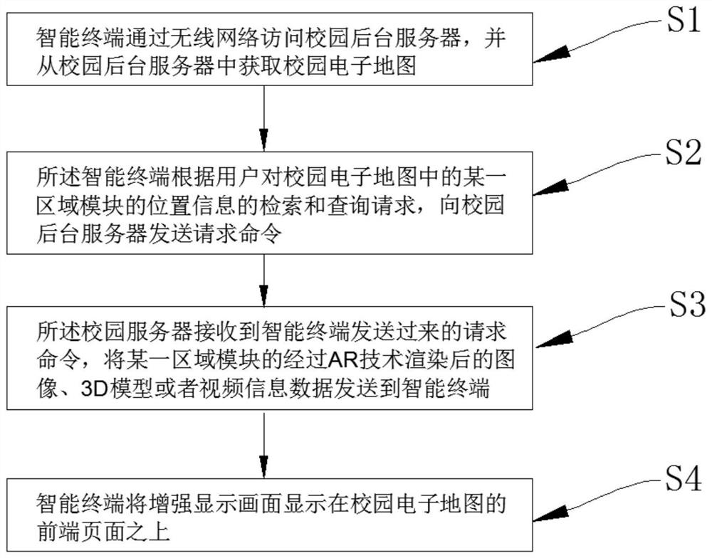
[0036] Such as figure 1 As shown, a campus guided method based on enhanced reality technology includes the following steps:
[0037] Step 1, the intelligent terminal accesses the campus background server through the wireless network, and obtains a campus electronic map from the campus background server;
[0038] Step 2, the intelligent terminal sends a request command to the campus background server according to the search and query request of the user's location information of a certain area module in the campus electronic map;
[0039] Step 3, the campus server receives the request command sent by the intelligent terminal, and sends an image, 3D model, or video information data rendered by an area module to the intelligent terminal;
[0040] Step 4, the intelligent terminal will enhance the display screen above the front page of the campus electronic map;
[0041] Among them, the campus electronic map includes a teaching building, a dormitory, a canteen, a shopping mall, a cour...
Embodiment 2
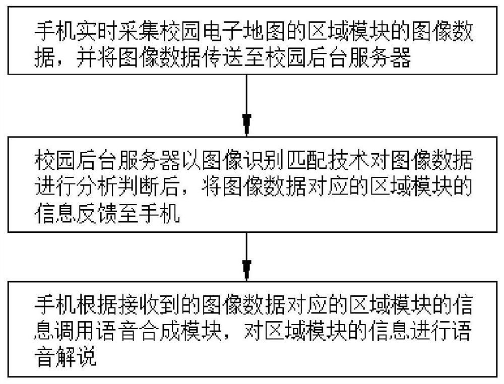
[0050] Please combine figure 1 as well as figure 2 On the basis of the first example, in order to enable campus new students to use the campus electronic map planning route, more convenient and quick to destination, the campus electronic map also includes route planning modules and speech synthesis modules, the route planning module is used for the recent recent The distance priority is to plan the shortest travel path for the user, and the speech synthesis module stores audio and audio data of the area module of the campus electronic map.
[0051] The user can enter the location information of the area module in the campus electronic map to be retrieved on the campus map, and set it to the end, then the campus electronic map sets the location information where the user is in real time is starting. When the starting point and end setting is completed, the campus electronic map automatically calls the route planning module to plan the shortest travel path for the user.
[0052] I...
Embodiment 3
[0056] This embodiment is basically the same as that of the second embodiment, and the intelligent terminal is that the smart terminal is a mobile phone, the phone has a split screen function, and can display a two-dimensional planar map and / or 3D map according to the user request.
[0057] The phone can be split screen to display a two-dimensional planar map and / or 3D map, which is more human. It can enhance its direction sensation by splitting the two-dimensional planar map and 3D map by split screen control.
[0058] A campus guideline method based on enhanced reality technologies can be applied not only in the campus environment, but also in tourist attractions and major shopping malls.
[0059] In summary, the present invention discloses a campus guided by enhanced reality technology, which includes:
[0060] 1. Based on campus-specific environments, combine campus electronic maps and enhancement techniques, allowing college new students to make quick and convenient under...
PUM
 Abstract
Description
Claims
Application Information
 - R&D
- Intellectual Property
- Life Sciences
- Materials
- Tech Scout
- Unparalleled Data Quality
- Higher Quality Content
- 60% Fewer Hallucinations
Browse by: Latest US Patents, China's latest patents, Technical Efficacy Thesaurus, Application Domain, Technology Topic, Popular Technical Reports.
© 2025 PatSnap. All rights reserved.Legal|Privacy policy|Modern Slavery Act Transparency Statement|Sitemap|About US| Contact US: help@patsnap.com


