
Urban query method, device and equipment based on longitude and latitude and storage medium

A query method and latitude and longitude technology, which is applied in the fields of longitude and latitude-based city query methods, equipment, storage media, and devices, and can solve problems such as excessive occupation of terminal computing resources, decreased search performance, and large-area overlapping of minimum adjacent rectangles.

Pending Publication Date: 2021-03-12
BEIJING SANKUAI ONLINE TECH CO LTD
View PDF0 Cites 5 Cited by
  • Summary
  • Abstract
  • Description
  • Claims
  • Application Information

AI Technical Summary

Problems solved by technology

[0004] However, in the scene of tens of billions of latitude and longitude mapping cities, using the R-tree index will result in a large area of ​​overlapping minimum adjacent rectangles, so it is necessary to use the ray method to judge the relationship between points and polygons to determine the relationship between points and polygons. relationship, resulting in an excessive amount of calculation, leading to a decrease in search performance, and at the same time causing an excessive occupation of terminal computing resources

Method used


Image

  • Urban query method, device and equipment based on longitude and latitude and storage medium
  • Urban query method, device and equipment based on longitude and latitude and storage medium
  • Urban query method, device and equipment based on longitude and latitude and storage medium

Examples


Embodiment Construction

[0109] In order to make the purpose, technical solution and advantages of the present application clearer, the implementation manners of the present application will be further described in detail below in conjunction with the accompanying drawings.

[0110] First, a brief introduction to the nouns involved in the embodiments of this application:

[0111] GeoHash index is a spatial index algorithm based on B-tree index and combined with the idea of ​​grid index. GeoHash encodes the spatial position as a string of characters, and the approximate range of the space can be obtained by comparing the strings. The longer the string, the more accurate the range represented.

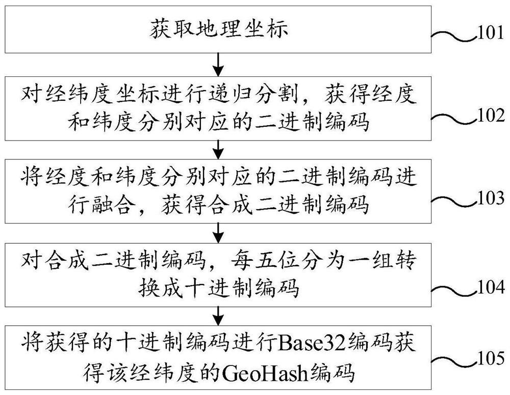
[0112] figure 1 A flow chart of the GeoHash encoding process shown in an exemplary embodiment of the application is shown, the process includes:

[0113] S101. Obtain geographic coordinates.

[0114] The geographic coordinates are latitude and longitude coordinates.

[0115] S102. Recursively segment the lat...


PUM


Abstract

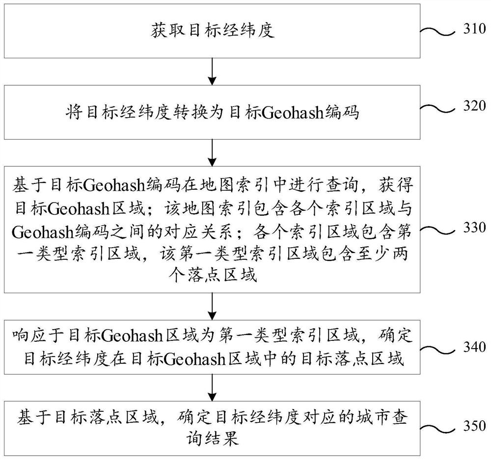
The invention relates to urban query method, device and equipment based on longitude and latitude and storage medium, and relates to the technical field of electronic maps. The method comprises the following steps: acquiring target longitude and latitude; converting the target longitude and latitude into a target Geohash code; based on the target Geohash code, querying in a map index containing the first type of index region to obtain a target Geohash region; in response to the fact that the target Geohash area is a first type index area, determining a target drop point area of the target longitude and latitude in the target Geohash area; and determining a city query result corresponding to the target longitude and latitude based on the target drop point area. Through the method, in the process of performing city query through longitude and latitude, the calculation amount of the computer equipment is reduced, and the search performance of the computer equipment is improved, so that excessive occupation of calculation resources of the computer equipment due to city query is reduced.

Description

technical field [0001] The present application relates to the technical field of electronic maps, in particular to a longitude-latitude-based city query method, device, equipment and storage medium. Background technique [0002] During the use of the electronic map, the user needs to obtain the city information corresponding to the latitude and longitude coordinates by inputting the latitude and longitude coordinates. [0003] In the related technology, by using the R-tree index, using the city boundary to divide, using the minimum adjacency rectangle to establish the leaf nodes, and then building up the intermediate nodes sequentially, so as to improve the search performance of searching the city by latitude and longitude. [0004] However, in the scene of tens of billions of latitude and longitude mapping cities, using the R-tree index will result in a large area of ​​overlapping minimum adjacent rectangles, so it is necessary to use the ray method to judge the relationshi...

Claims


Application Information

Patent Timeline
IPC IPC(8): G06F16/22G06F16/248G06F16/29
CPCG06F16/2228G06F16/29G06F16/248
Inventor 赵领杰秦思源王露珠
Owner BEIJING SANKUAI ONLINE TECH CO LTD
Learn More