Method for solving data imbalance of remote sensing image multi-classification scene segmentation algorithm

A remote sensing image and scene segmentation technology, applied in the field of deep learning, can solve the problem of data imbalance in multi-classification scene segmentation algorithms of remote sensing images, and achieve the effect of solving algorithm failure and improving accuracy

Pending Publication Date: 2021-03-19
土豆数据科技集团有限公司
View PDF5 Cites 0 Cited by
  • Summary
  • Abstract
  • Description
  • Claims
  • Application Information

AI Technical Summary

Problems solved by technology

[0008] Aiming at the deficiencies of the prior art, the present invention provides a method for solving the unbalanced data of the remote sensing image multi-classification scene segmentation algorithm, which solves the problems mentioned in the background technology

Method used


Image

  • Method for solving data imbalance of remote sensing image multi-classification scene segmentation algorithm
  • Method for solving data imbalance of remote sensing image multi-classification scene segmentation algorithm
  • Method for solving data imbalance of remote sensing image multi-classification scene segmentation algorithm

Examples


Embodiment Construction

[0029] The following will clearly and completely describe the technical solutions in the embodiments of the present invention with reference to the accompanying drawings in the embodiments of the present invention. Obviously, the described embodiments are only some, not all, embodiments of the present invention. Based on the embodiments of the present invention, all other embodiments obtained by persons of ordinary skill in the art without making creative efforts belong to the protection scope of the present invention.

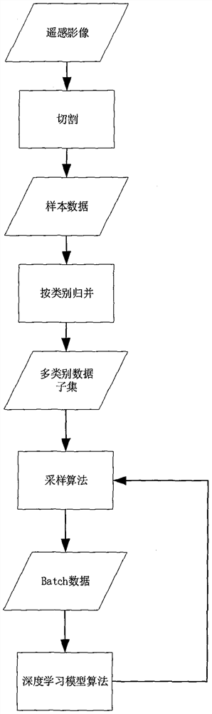
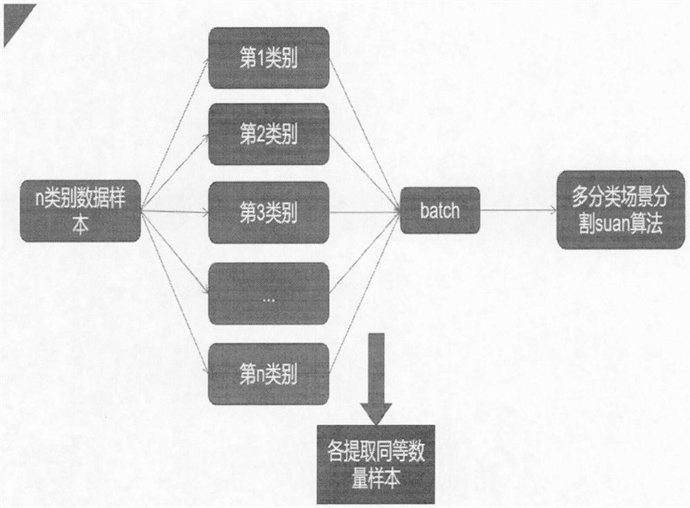
[0030] Please refer to Figure 1-3 As shown, the present invention proposes a method for solving remote sensing image multi-classification scene segmentation algorithm data imbalance, the method includes the following steps:

[0031] A. Cut the remote sensing images and labels according to a fixed size, and output the sample data set;

[0032] B. Traverse the sample data and classify it into sample data subsets according to the sample category;

[0033] C. T...


PUM


Abstract

The invention discloses a method for solving data imbalance of a remote sensing image multi-classification scene segmentation algorithm, and the method comprises the following steps: A, cutting a remote sensing image and a label according to a fixed size, and outputting a sample data set; b, traversing the sample data, and classifying the sample data into a sample data subset according to sample categories; c, performing sampling from the data subset to obtain a batch data set; d, providing the batch data set for algorithm training; and E, repeating the steps C and D. The method comprises thefollowing steps: cutting a remote sensing image and a label according to a fixed size, outputting a sample data set, traversing sample data, classifying the sample data into a sample data subset according to sample categories, performing sampling from the data subset to obtain a batch data set, providing the batch data set for algorithm training, repeatedly performing sampling to obtain a batch data set, and carrying out algorithm training. The problem of algorithm failure caused by imbalance of sample data in an actual scene is solved, and the accuracy of the algorithm is improved.

Description

technical field [0001] The invention belongs to the technical field of deep learning technology, and specifically relates to a method for solving data imbalance of multi-category scene segmentation algorithms of remote sensing images. Background technique [0002] Remote sensing image (abbreviation: RS, English: Remote Sensing Image) refers to the film or photo that records the electromagnetic wave size of various ground features, mainly divided into aerial photos and satellite photos. [0003] Remote sensing images processed by computers must be digital images. Analog images obtained by photography must be converted to analog / digital (A / D) by image scanners; digital data obtained by scanning must be transferred to general-purpose carriers such as CCT that can be read by general digital computers. Computer image processing should be carried out in the image processing system. The image processing system is composed of hardware (computer, monitor, digitizer, tape drive, etc...

Claims


Application Information

Patent Timeline
Patent Type & Authority Applications(China)
IPC IPC(8): G06K9/62
CPCG06F18/214G06F18/24
Inventor 冯喆王江安
Owner 土豆数据科技集团有限公司
Why Eureka
Try Eureka