
Method and system for quantifying ecological geological environment degradation degree of agricultural and pastoral transition zone

A technology of geological environment and degradation degree, applied in image data processing, instruments, image analysis, etc., can solve the problem of lack of systematic quantification system and method of ecological geological environment degradation degree in transition zone of agriculture, animal husbandry and forestry.

Pending Publication Date: 2021-03-26
河北地质大学
View PDF4 Cites 0 Cited by
  • Summary
  • Abstract
  • Description
  • Claims
  • Application Information

AI Technical Summary

Problems solved by technology

[0004] Through the above analysis, the existing problems and defects of the existing technology are: the existing technology lacks a comprehensive and simple and practical quantitative system and method for the degradation degree of the eco-geological environment in the transitional zone of agriculture, animal husbandry and forestry

Method used

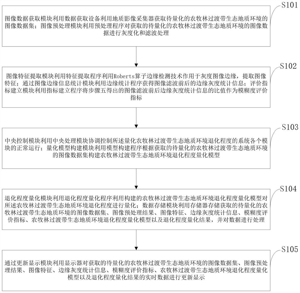
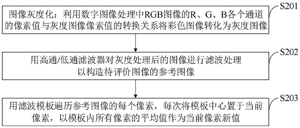

Image

  • Method and system for quantifying ecological geological environment degradation degree of agricultural and pastoral transition zone
  • Method and system for quantifying ecological geological environment degradation degree of agricultural and pastoral transition zone
  • Method and system for quantifying ecological geological environment degradation degree of agricultural and pastoral transition zone

Examples


Embodiment Construction

[0058] In order to make the object, technical solution and advantages of the present invention more clear, the present invention will be further described in detail below in conjunction with the examples. It should be understood that the specific embodiments described here are only used to explain the present invention, not to limit the present invention.

[0059] Aiming at the problems existing in the prior art, the present invention provides a method and system for quantifying the degree of degradation of the ecological geological environment in the transitional zone of agriculture, animal husbandry and forestry. The present invention will be described in detail below in conjunction with the accompanying drawings.

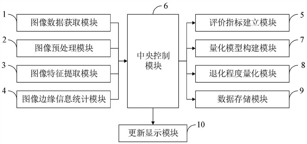
[0060] like figure 1 As shown, the system for quantifying the degree of degradation of the eco-geological environment in the agricultural, animal husbandry and forest transition zone provided by the embodiment of the present invention includes: image data acquisi...


PUM


Abstract

The invention belongs to the technical field of environmental degradation degree quantification, and discloses a method and a system for quantifying the ecological geological environment degradation degree of an agricultural and pastoral forest transition zone. The system for quantifying the ecological geological environment degradation degree of the agricultural and pastoral transition zone comprises an image data acquisition module, an image preprocessing module, an image feature extraction module, an image edge information statistics module, an evaluation index establishment module, a central control module, a quantification model construction module, a degradation degree quantification module and a data storage module, and an update display module. Through the evaluation index establishment module, the quantitative model construction module, the degradation degree quantification module and the like, degradation evaluation system indication degree diagnosis methods with different utilization degrees are established, and grassland vegetation and soil index systems with different utilization modes and different degradation degrees are screened; grassland degradation index system screening and degradation degree difference, sensitivity and uncertainty analysis are carried out, the land degradation degree can be fully represented, and practical operation significance is achieved.

Description

technical field [0001] The invention belongs to the technical field of quantifying the degree of environmental degradation, and in particular relates to a method and system for quantifying the degree of degradation of the eco-geological environment in transition zones of agriculture, animal husbandry and forestry. Background technique [0002] At present, land degradation mainly manifests itself in the decline or loss of biological or economic productivity and value of land. Land degradation has many manifestations, including soil degradation, vegetation degradation, reduction or loss of biodiversity, and reduction or loss of land use value. [0003] Great progress has been made in the theory and method of land degradation assessment at home and abroad, which is reflected in the "World Atlas of Desertification" published in 1997 and the assessment of land degradation in other regions. There are currently three evaluation theories, namely Global Anthropogenic Soil Degradatio...

Claims


Application Information

Patent Timeline
IPC IPC(8): G06Q10/06G06Q50/02G06T7/13
CPCG06Q10/06393G06Q10/067G06Q50/02G06T7/13
Inventor 梁钊云玉攀孙海微魏浩侯中帅
Owner 河北地质大学
Learn More