Unmanned aerial vehicle SAR self-focusing method based on aerial carrier track deviation estimation

A self-focusing and track technology, which is used in radio wave measurement systems, radio wave reflection/re-radiation, utilization of re-radiation, etc., can solve the problem of inability to adapt to envelope errors, inability to equip high-precision inertial navigation, and defocusing of imaging results. and other problems to achieve the effect of solving two-dimensional space variability and achieving self-focusing

Pending Publication Date: 2021-03-30
BEIJING INSTITUTE OF TECHNOLOGYGY
View PDF0 Cites 1 Cited by
  • Summary
  • Abstract
  • Description
  • Claims
  • Application Information

AI Technical Summary

Problems solved by technology

The first type is based on high-precision inertial navigation system (INS) for motion compensation or back projection (BP) imaging. However, when the radar works in the high-frequency band, the accuracy of INS often cannot meet the imaging accuracy requirements, resulting in defocused imaging results. Moreover, for small unmanned aerial vehicles, due to the strict constraints of load volume and load, it is often impossible to equip high-precision inertial navigation
The second type is the self-focusing method bas

Method used


Image

  • Unmanned aerial vehicle SAR self-focusing method based on aerial carrier track deviation estimation
  • Unmanned aerial vehicle SAR self-focusing method based on aerial carrier track deviation estimation
  • Unmanned aerial vehicle SAR self-focusing method based on aerial carrier track deviation estimation

Examples


Embodiment 1

[0085] The proposed technology is used to process the data of the slow UAV-borne SAR flying experiment to further prove the feasibility and effectiveness of the proposed technology. Table 1 shows the parameters of the slow UAV-borne SAR flying experiment.

[0086] Table 1 Parameters of UAV-borne SAR flying experiment

[0087] parameter / unit value Operating mode side view strip Azimuth beamwidth / ° 10 Action distance / km 1 Synthetic distance bandwidth / MHz 1160 UAV flying height / m 200 Flight speed / m / s 20

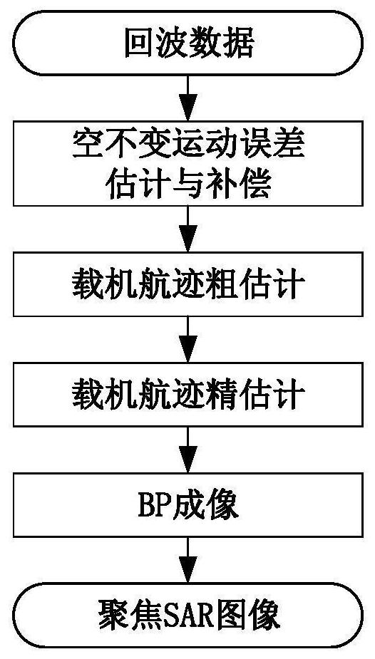
[0088] By processing the SAR echo data of a slow unmanned fixed-wing aircraft, the track deviation estimation results and two-dimensional imaging results are obtained as follows: Figure 4 , Figure 5 shown. It can be seen from the image that BP imaging is performed based on inertial navigation information, and the image is seriously defocused (see Figure 5 (a)); Imaging based on traditional motion compensation algorithms...


PUM


Abstract

The invention discloses an unmanned aerial vehicle SAR self-focusing method based on aerial carrier track deviation estimation. According to the method, the aerial carrier track deviation is estimatedon the basis of echo data, and the accurate estimation of the aerial carrier track deviation is realized by utilizing a coarse-to-fine step-by-step self-focusing strategy, so that the two-dimensionalspace-variant property of motion errors is fundamentally solved, the low-speed unmanned aerial vehicle-mounted SAR self-focusing is realized, and a high-resolution unmanned aerial vehicle-mounted SARimage is obtained.

Description

technical field [0001] The invention relates to the technical field of synthetic aperture radar, in particular to an unmanned aerial vehicle-borne synthetic aperture radar (SAR) self-focusing method based on aircraft track deviation estimation. Background technique [0002] UAV-borne SAR is a technology that uses UAVs for synthetic aperture imaging, which can achieve all-day and all-weather earth observation, and is widely used in terrain exploration and battlefield reconnaissance. At present, azimuth wide-beam imaging and motion compensation for slow UAV-borne SAR have become a hot spot in the development of UAV-borne SAR technology. [0003] Due to its small size (such as 20 cm square), light weight (such as a 1 kg UAV-borne SAR system), low flying altitude and slow flying speed (such as a flying height of 200 meters and a flying speed of 20 meters per second), it is affected by airflow. Influenced by its own simple dynamic structure, the flight trajectory of slow-speed U...

Claims


Application Information

Patent Timeline
IPC IPC(8): G01S13/90
CPCG01S13/9019G01S13/9052
Inventor 丁泽刚龙腾王岩李凌豪赵祎昆
Owner BEIJING INSTITUTE OF TECHNOLOGYGY
Why Eureka
Try Eureka