Road information intelligent automatic extraction method

A technology for automatic extraction and road information, applied in the field of information technology, can solve the problem of accurate extraction of road surface and roadside points

Active Publication Date: 2021-04-20
星际空间(天津)科技发展有限公司
View PDF9 Cites 0 Cited by
  • Summary
  • Abstract
  • Description
  • Claims
  • Application Information

AI Technical Summary

Problems solved by technology

The system can quickly acquire the 3D point cloud data of the road and both sides without affecting the traffic, but how to quickly and accurately extract the road surface and roadside points from the point cloud of different road environments is still a difficulty
[000

Method used


Image

  • Road information intelligent automatic extraction method
  • Road information intelligent automatic extraction method
  • Road information intelligent automatic extraction method

Examples


Embodiment 1

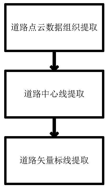
[0057] figure 1 It is an intelligent automatic extraction method for road information, such as figure 1 As shown, the method includes the following steps: a method for intelligent automatic extraction of road information, characterized in that the method includes the following steps:

[0058] Road point cloud data organization and extraction: manage the point cloud data collected by the laser through the Kd-tree method, and index the point cloud data through the point cloud coordinate range;

[0059] Road centerline extraction: According to the fixed interval point cloud index file, extract point cloud data one by one according to the coordinate range of the index file, extract key points, calculate the coordinates of the corner points of the central isolation zone, calculate the coordinates of the center point of the road through the average value and connect to generate the road center Wire;

[0060] Road vector marking extraction: After obtaining the accurate road center ...


PUM


Abstract

The invention discloses an intelligent automatic road information extraction method and relates to the field of informatization. The method comprises the following steps of road point cloud data organization and extraction, road center line extraction and road vector marked line extraction. The method is advantaged in that the road marking position can be quickly and accurately obtained through a fuzzy positioning clustering extraction method; finally, the electronic vector marking line is formed. The method can be widely applied to the fields of high-precision map making, smart roads, cities, traffic planning and design and the like, and can effectively assist smart city construction and management for a long time.

Description

technical field [0001] The invention relates to the field of informatization, in particular to a method for managing point cloud data through Kd-tree, which can quickly dispatch point cloud data. Among them, the method of extracting road key points by interval greatly reduces the workload of data processing. This method adopts the method of road longitudinal line management, and can accurately calculate the road centerline. Through the method of fuzzy positioning and clustering extraction, the position of road markings can be obtained quickly and accurately. The resulting electronic vector reticle. It can be widely used in the fields of high-precision map production, smart highways, urban and traffic planning and design, and can effectively assist the construction and management of smart cities for a long time. Set up intelligent automatic extraction methods for road information. Background technique [0002] my country's expressway has exceeded 150,000 kilometers, rankin...

Claims


Application Information

Patent Timeline
IPC IPC(8): G06K9/00G06K9/62G06T5/00G06F16/51G06F16/56G06F16/583
CPCY02T10/40
Inventor 闫继扬江宇王国飞黄恩兴江贻芳李建平王力李振李文棋王刚
Owner 星际空间(天津)科技发展有限公司
Why Eureka
Try Eureka