A Quantitative Estimation Method of Land Use Change and Carbon Stock Based on Remote Sensing Data

A technology of remote sensing data and land, applied in the field of remote sensing, can solve problems such as variable collinearity

Active Publication Date: 2022-05-27
平衡机器科技(深圳)有限公司
View PDF3 Cites 0 Cited by
  • Summary
  • Abstract
  • Description
  • Claims
  • Application Information

AI Technical Summary

Problems solved by technology

[0006] Although the regression model commonly used in domestic research on regional carbon storage is simple to use, collinearity problems are likely to exist between variables

Method used


Image

  • A Quantitative Estimation Method of Land Use Change and Carbon Stock Based on Remote Sensing Data
  • A Quantitative Estimation Method of Land Use Change and Carbon Stock Based on Remote Sensing Data
  • A Quantitative Estimation Method of Land Use Change and Carbon Stock Based on Remote Sensing Data

Examples


Embodiment Construction

[0025] The present invention will be described in further detail below with reference to the accompanying drawings and specific embodiments.

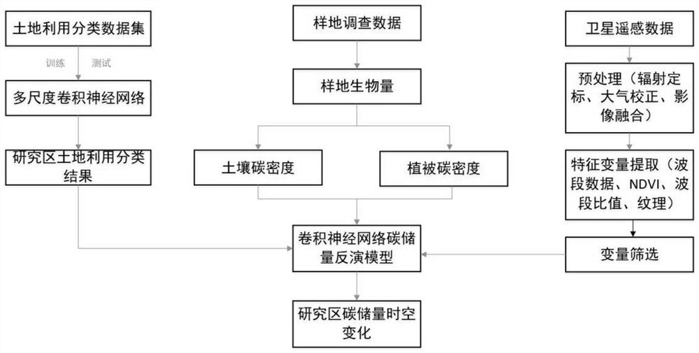
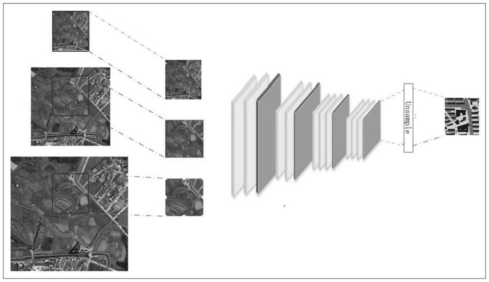
[0026] like figure 1 The shown quantitative estimation method of land use change and carbon stock based on remote sensing data includes the following steps:

[0027] Step 1. Image download: According to the research needs, download the remote sensing images of the designated research area over the years. Obtain annotated land classification datasets;

[0028] Step 2: Image preprocessing: perform geometric correction, mosaicking, cropping, radiometric calibration, atmospheric correction and other preprocessing operations on remote sensing images;

[0029] Geometric correction: The process of correcting and eliminating the geometric errors of remote sensing images using a series of mathematical models.

[0030] Radiometric calibration: Convert the value or voltage recorded by the sensor into absolute radiance.

[0031] Atmospheric cor...


PUM


Abstract

The invention discloses a method for quantitatively estimating land use change and carbon storage based on remote sensing data, comprising the following steps: downloading images; preprocessing images; classifying land use; Correlation analysis is carried out between the medium carbon storage and each eigenvalue, and the eigenvalues ​​with significant correlation are selected for modeling; the selected eigenvalues ​​are normalized as the input layer of the convolutional neural network, and the calculated carbon The density is put into the network output layer for network training, and the trained model is used to quantitatively estimate the carbon storage of the area to be studied. The present invention is based on a layered learning framework of a multi-scale convolutional neural network, enabling better land use classification results. Based on different eigenvalues ​​in images and carbon density obtained from ground survey data, the nonlinear relationship between characteristic variables and carbon storage can be better fitted, and the final quantitative estimation of regional carbon storage can be improved.

Description

technical field [0001] The invention relates to the field of remote sensing, in particular to a quantitative estimation method for land use change and carbon storage based on remote sensing data. Background technique [0002] Land use change is the largest uncertainty factor in estimating carbon storage and release in terrestrial ecosystems. Land use change affects the carbon fixation, accumulation and release of soil and vegetation in the ecosystem, which in turn affects the carbon cycle process of the entire ecosystem and changes the original carbon storage and carbon release patterns of the ecosystem. [0003] Accurately predicting the impact of future land use changes on regional carbon storage is of great significance in land use decision-making and urban expansion planning. The existing carbon storage calculation methods mainly include remote sensing image direct estimation method, vegetation index estimation method, spectral measurement analysis method, InVEST model,...

Claims


Application Information

Patent Timeline
Patent Type & Authority Patents(China)
IPC IPC(8): G06V20/13G06K9/62G06N3/04G06N3/08G06V10/774G06V10/764
CPCG06N3/04G06N3/08G06V20/13G06F18/241G06F18/214
Inventor 李君吕新杰沈焰姜峥超
Owner 平衡机器科技(深圳)有限公司
Why Eureka
Try Eureka