Farmland corn straw satellite remote sensing extraction method and device

A corn stalk and satellite remote sensing technology, applied in the field of agricultural remote sensing, can solve the problems of different monitoring objects, different shapes, and few straw plants, so as to improve the extraction accuracy and efficiency and reduce manual investigation

Pending Publication Date: 2021-05-28
BEIJING RES CENT FOR INFORMATION TECH & AGRI
View PDF0 Cites 1 Cited by
  • Summary
  • Abstract
  • Description
  • Claims
  • Application Information

AI Technical Summary

Problems solved by technology

[0003] At present, the prevention and control of straw incineration mainly relies on on-the-spot investigation by supervisory personnel, and then statistical reporting, which is time-consuming, laborious and inefficient
At present, there are few studies on remote sensing monitoring of straw plants. The relevant research is on the remote sensing monitoring of the straw coverage after the soil and straw stubble are mixed after the straw is returned to the field. The focus is on the coverage of the crushed corn after harvest. Remote sensing monitoring is carried out on the field of straw crushed stubble. The monitoring object is the mixture of crushed straw crushed stubble and soil, while the monitoring object of the upright corn straw in the field is the complete corn straw plant on the farmland. The monitoring objects of the two are completely different, and the shape is also different. Therefore, the method of monitoring and extracting corn stalks in the field and the degree of straw coverage are also completely different

Method used


Image

  • Farmland corn straw satellite remote sensing extraction method and device
  • Farmland corn straw satellite remote sensing extraction method and device
  • Farmland corn straw satellite remote sensing extraction method and device

Examples


Embodiment Construction

[0031] In order to make the purpose, technical solutions and advantages of the present invention clearer, the technical solutions in the present invention will be clearly and completely described below in conjunction with the accompanying drawings in the present invention. Obviously, the described embodiments are part of the embodiments of the present invention , but not all examples. Based on the embodiments of the present invention, all other embodiments obtained by persons of ordinary skill in the art without creative efforts fall within the protection scope of the present invention.

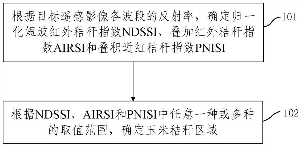
[0032] Combine below Figure 1-Figure 5 The satellite remote sensing extraction method and device for farmland corn stalks of the present invention are described. figure 1 It is one of the schematic flow charts of the satellite remote sensing extraction method for farmland corn stalks provided by the present invention, such as figure 1 As shown, the present invention provides a satellite re...


PUM


Abstract

The invention provides a farmland corn straw satellite remote sensing extraction method and device, and the method comprises the steps: determining a normalized short wave infrared straw index NDSSI, a superposed infrared straw index AIRSI and a superposed near red straw index PNISI according to the reflectivity of each wave band of a target remote sensing image; according to the value range of any one or more of the NDSSI, the AIRSI and the PNISI, determining the corn straw area. According to the method, the farmland corn straw autumn and winter remote sensing monitoring result is determined through the three novel straw indexes including the normalized short-wave infrared straw index, the stacked infrared straw index and the stacked near-red straw index, the farmland corn straw extraction precision and efficiency can be improved, manual investigation is reduced, and data support is provided for straw incineration supervision.

Description

technical field [0001] The invention relates to the technical field of agricultural remote sensing, in particular to a satellite remote sensing extraction method and device for farmland corn stalks. Background technique [0002] Most of the corn stalks in the farmland have been harvested when the corn is harvested, but in some areas that are going to be planted with spring corn and retail planting areas in the coming year, the stalks are not harvested after the corn harvest season, and are distributed in the field upright or lying down. These straws are very easy to be burned in autumn and winter or the next spring, and are high-risk key areas for the supervision of straw burning by agricultural or environmental protection departments. The investigation of straw distribution in farmland is the basis for the prevention and control of straw burning. [0003] At present, the prevention and control of straw incineration mainly relies on on-the-spot surveys by supervisors, and t...

Claims


Application Information

Patent Timeline
IPC IPC(8): G06K9/00G06K9/46
CPCG06V20/188G06V10/40
Inventor 李存军周静平淮贺举胡海棠陶欢王佳宇覃苑石建安
Owner BEIJING RES CENT FOR INFORMATION TECH & AGRI
Why Eureka
Try Eureka