Non-data region flood real-time forecasting method based on multi-source satellite rainfall information and runoff production constraint correction

A data-free, satellite-based technology, applied in forecasting, resources, and weather forecasting, etc., can solve problems such as unstable flood forecast results and jumping flood processes, and achieve the effect of improving the accuracy of flood forecasting

Pending Publication Date: 2021-06-01
DALIAN UNIV OF TECH
View PDF0 Cites 2 Cited by
  • Summary
  • Abstract
  • Description
  • Claims
  • Application Information

AI Technical Summary

Problems solved by technology

In addition, due to the lack of constraints in the correction process, the flood process after correction often jumps seriously, and the flood forecast results are unstable
However, there is still no method based on multi-source satellite precipitation products and runoff constraint correction to forecast floods in areas without data in real time

Method used


Image

  • Non-data region flood real-time forecasting method based on multi-source satellite rainfall information and runoff production constraint correction
  • Non-data region flood real-time forecasting method based on multi-source satellite rainfall information and runoff production constraint correction
  • Non-data region flood real-time forecasting method based on multi-source satellite rainfall information and runoff production constraint correction

Examples


Embodiment Construction

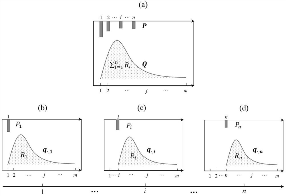
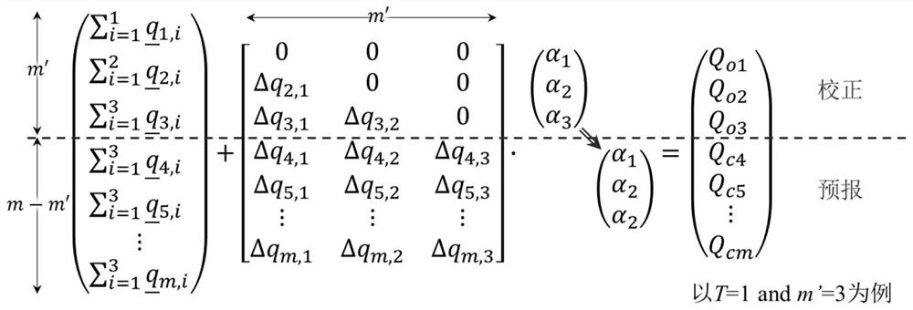
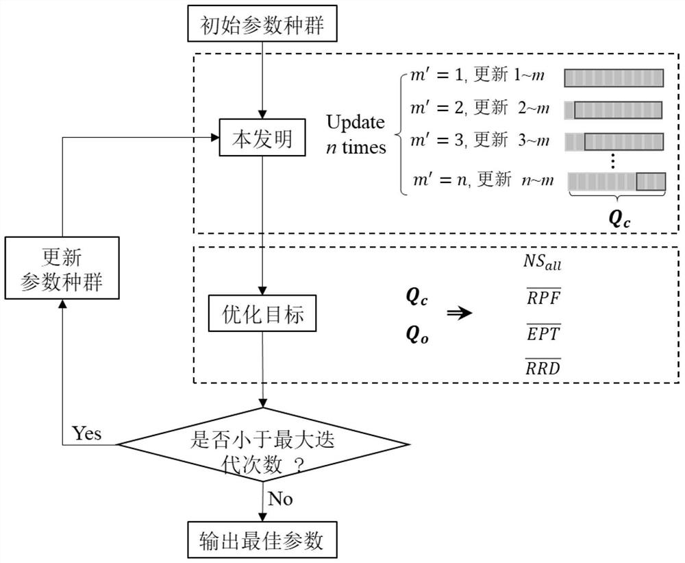
[0061] The invention proposes a real-time flood forecasting method in areas without data based on multi-source satellite precipitation information and runoff constraint correction on the basis of driving a hydrological model with multi-source satellite precipitation information.

[0062] Below by embodiment, the present invention will be further described.

[0063] The Xiaoergou watershed is located on the west bank of the Nenjiang River, originating from the Daxinganling area of ​​the Inner Mongolia Autonomous Region, with a controlled drainage area of ​​16,761km 2 , the confluence time is greater than or equal to 1 day. The watershed as a whole is high in the west and low in the east, with fertile soil, and a large area of ​​farmland has been reclaimed on both sides. Gannan County on the right bank has a large-scale irrigation area in Chahayang, which is the largest irrigation area in Heilongjiang Province and one of the four major irrigation areas in Northeast my country. ...


PUM


Abstract

The invention provides a data-free area flood real-time forecasting method based on multi-source satellite rainfall information and runoff production constraint correction, and belongs to the technical field of flood real-time forecasting. The method comprises the steps: splitting drainage basin outlet flow composition, and obtaining a correction object; after a hydrological model is driven by a multi-source satellite precipitation product, obtaining a plurality of sequences of the correction object obtained in the first step, and carrying out runoff production constraint correction and flow forecasting by taking a range formed by extreme values of the plurality of sequences as a constraint; finally, evaluating the forecast performance of each flood according to the traditional evaluation indexes, and carrying out the parameter calibration. According to the method, the multisource satellite rainfall information is converted into the upper limit and the lower limit of runoff, so that the runoff is subjected to constrained correction, the flood forecasting precision of a hydrological model driven by a satellite rainfall product can be greatly improved, the flood forecasting of a region without rainfall data is supported, and a new thought is provided for the application of the multisource satellite rainfall product.

Description

technical field [0001] The invention belongs to the technical field of real-time flood forecasting, and relates to a real-time flood forecasting method in areas without data based on multi-source satellite precipitation information and runoff constraint correction. Background technique [0002] Real-time flood forecasting can effectively mitigate the losses caused by floods. Since rainfall is the primary information driving hydrological models, accurate rainfall information plays a vital role in real-time flood forecasting. At present, rainfall information based on ground station observations is widely used in flood forecasting. However, due to the large number of rivers in our country, there are still many areas without rainfall monitoring stations due to the constraints of investment funds, terrain and climate, and equipment maintenance. In recent years, with the rapid development of satellite remote sensing technology, quantitative rainfall analysis technology provides ...

Claims


Application Information

Patent Timeline
Patent Type & Authority Applications(China)
IPC IPC(8): G06Q10/04G06Q10/06G06Q50/26G01W1/10
CPCG01W1/10G06Q10/04G06Q10/06393G06Q50/26Y02A10/40Y02A90/10
Inventor 窦延虹叶磊辛卓航李昱张弛欧阳文宇李晓阳顾学志
Owner DALIAN UNIV OF TECH
Why Eureka
Try Eureka