Method and system for establishing and verifying remote sensing image classification model, and electronic equipment
A technology of remote sensing images and classification models, applied in the field of remote sensing images, can solve the problems of falsely high verification results and inability to give accurate and objective results.
- Summary
- Abstract
- Description
- Claims
- Application Information
AI Technical Summary
Problems solved by technology
Method used
Image
Examples
Embodiment Construction
[0055] The principles and features of the present invention will be described below in conjunction with the accompanying drawings, and the examples given are only used to explain the present invention, and are not intended to limit the scope of the present invention.
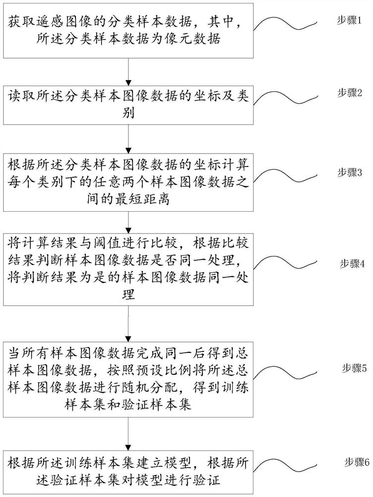
[0056] Such as figure 1 As shown, a remote sensing image classification model establishment method, including:
[0057] Step 1, obtaining classified sample data of remote sensing images, wherein the classified sample data is pixel data;
[0058] Step 2, read the coordinates and categories of the classified sample image data;
[0059] Step 3, calculating the shortest distance between any two sample image data under each category according to the coordinates of the classified sample image data;
[0060] Step 4, comparing the calculation result with the threshold value, judging whether the sample image data is processed in the same way according to the comparison result, and performing the same processing on the ...
PUM
 Abstract
Description
Claims
Application Information
 - R&D
- Intellectual Property
- Life Sciences
- Materials
- Tech Scout
- Unparalleled Data Quality
- Higher Quality Content
- 60% Fewer Hallucinations
Browse by: Latest US Patents, China's latest patents, Technical Efficacy Thesaurus, Application Domain, Technology Topic, Popular Technical Reports.
© 2025 PatSnap. All rights reserved.Legal|Privacy policy|Modern Slavery Act Transparency Statement|Sitemap|About US| Contact US: help@patsnap.com


