Large-width imaging load image remapping method and system

A remapping and imaging technology, applied in the field of remote sensing, can solve unconsidered problems, achieve the effect of eliminating geometric distortion, reasonable method, and simple implementation

Active Publication Date: 2021-06-15
SHANGHAI SATELLITE ENG INST
View PDF4 Cites 0 Cited by
  • Summary
  • Abstract
  • Description
  • Claims
  • Application Information

AI Technical Summary

Problems solved by technology

This method can preserve the size information of the imaging area corresponding to the pixels in the original image to a certain ex

Method used


Image

  • Large-width imaging load image remapping method and system
  • Large-width imaging load image remapping method and system
  • Large-width imaging load image remapping method and system

Examples


Embodiment Construction

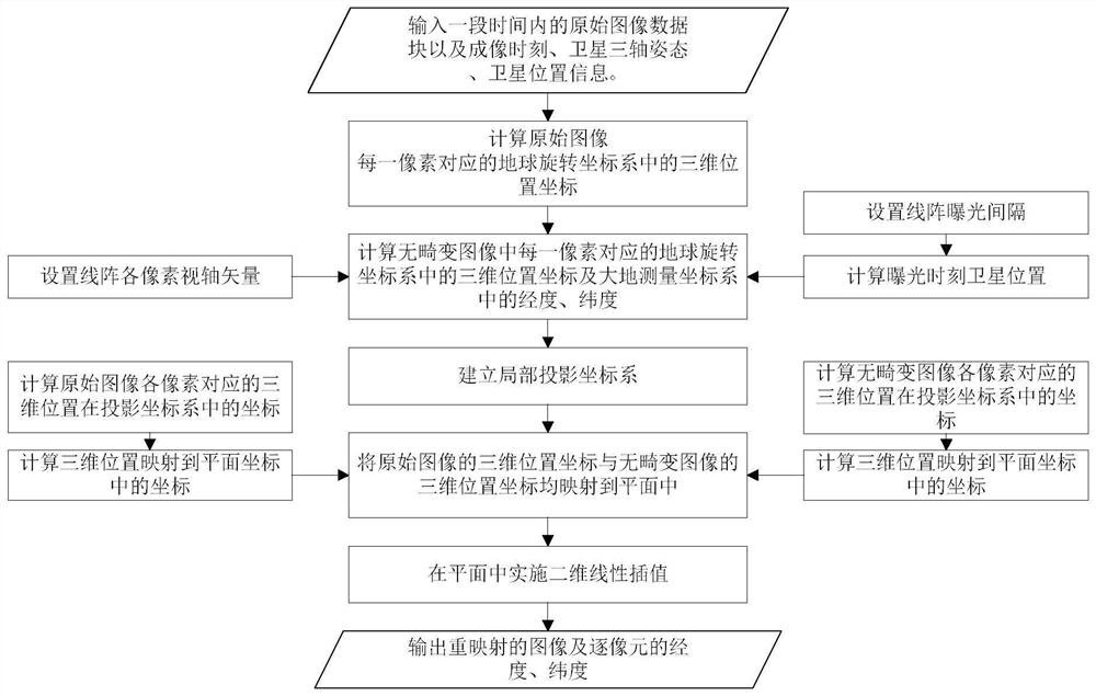
[0062] The present invention will be described in detail below in conjunction with specific embodiments. The following examples will help those skilled in the art to further understand the present invention, but do not limit the present invention in any form. It should be noted that those skilled in the art can make several changes and improvements without departing from the concept of the present invention. These all belong to the protection scope of the present invention.

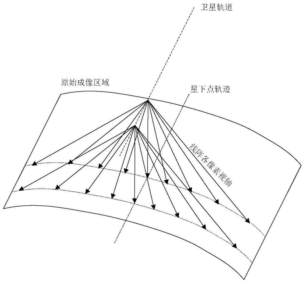
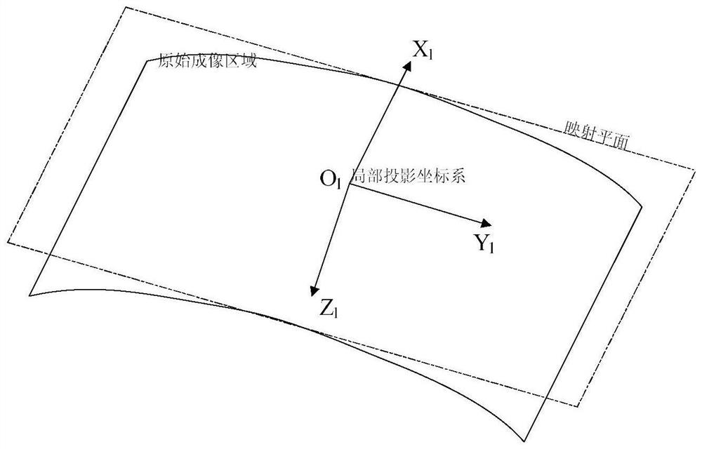
[0063] Such as figure 1 As shown, the image remapping method of a large-width imaging payload provided by the present invention, for a large-width imaging payload, due to factors such as the working mode of the payload and the curvature of the earth, there will be geometric distortion in the directly acquired image. The more effective method of geometric distortion correction is to geo-locate the pixels in the image pixel by pixel. According to the imaging time, satellite three-axis attitude, and satell...


PUM


Abstract

The invention provides a large-width imaging load image remapping method and a large-width imaging load image remapping system. The method comprises the following steps: inputting original image data blocks within a period of time and imaging time, satellite three-axis attitude and satellite position information; and carrying out pixel-by-pixel geographic positioning on the original image data. And calculating the geolocation of each pixel in the distortionless image. And establishing a local projection coordinate system. And mapping the three-dimensional position coordinates of the original image and the distortionless image to a plane. And performing two-dimensional linear interpolation in the plane to obtain a remapped image. And outputting the remapped image and the longitude and latitude of each pixel. The method is reasonable and easy to implement, and can be effectively applied to image remapping of a large-width imaging load.

Description

technical field [0001] The invention relates to the field of remote sensing, in particular to a method and system for remapping images of large and wide imaging payloads. Background technique [0002] The swath width is an important indicator of the satellite load, which affects the observation coverage of the satellite. With the maturity of the moving parts on the satellite, the imaging load with a large width is widely used in the field of remote sensing. In order to realize large and wide imaging, there are various ways to realize it, such as: high orbit height, vertical orbit scanning, conical scanning, multi-camera stitching, multi-detector array stitching, etc. [0003] When the imaging load width increases, the influence of the curvature of the earth will be obvious, resulting in obvious geometric distortion in the image, and the image data needs to be remapped (sampled). Theoretically, the imaging targets of remote sensing instruments for earth observation are distr...

Claims


Application Information

Patent Timeline
IPC IPC(8): G06T3/00G06T5/00
CPCG06T3/0031G06T5/006G06T2207/10032
Inventor 郭玲玲党建成汪少林桑峰代海山林两魁杨春燕杨彬
Owner SHANGHAI SATELLITE ENG INST
Why Eureka
Try Eureka