
A remote sensing image matching optimization method, device, electronic equipment and storage medium

A technology of remote sensing images and optimization methods, which is applied to instruments, character and pattern recognition, scene recognition, etc., can solve problems such as poor matching effect, and achieve the effect of reducing time overhead, improving matching efficiency, and reducing the number of

Active Publication Date: 2020-08-28
ZHUHAI DAHENGQIN TECH DEV CO LTD
View PDF10 Cites 0 Cited by
  • Summary
  • Abstract
  • Description
  • Claims
  • Application Information

AI Technical Summary

Problems solved by technology

[0005] In view of this, the embodiment of the present invention provides a remote sensing image matching optimization method, device, electronic equipment, and storage medium to solve the poor matching effect when the existing image matching method for ordinary images is directly applied to remote sensing images of low-altitude aircraft The problem

Method used


Image

  • A remote sensing image matching optimization method, device, electronic equipment and storage medium
  • A remote sensing image matching optimization method, device, electronic equipment and storage medium
  • A remote sensing image matching optimization method, device, electronic equipment and storage medium

Examples


Embodiment 1

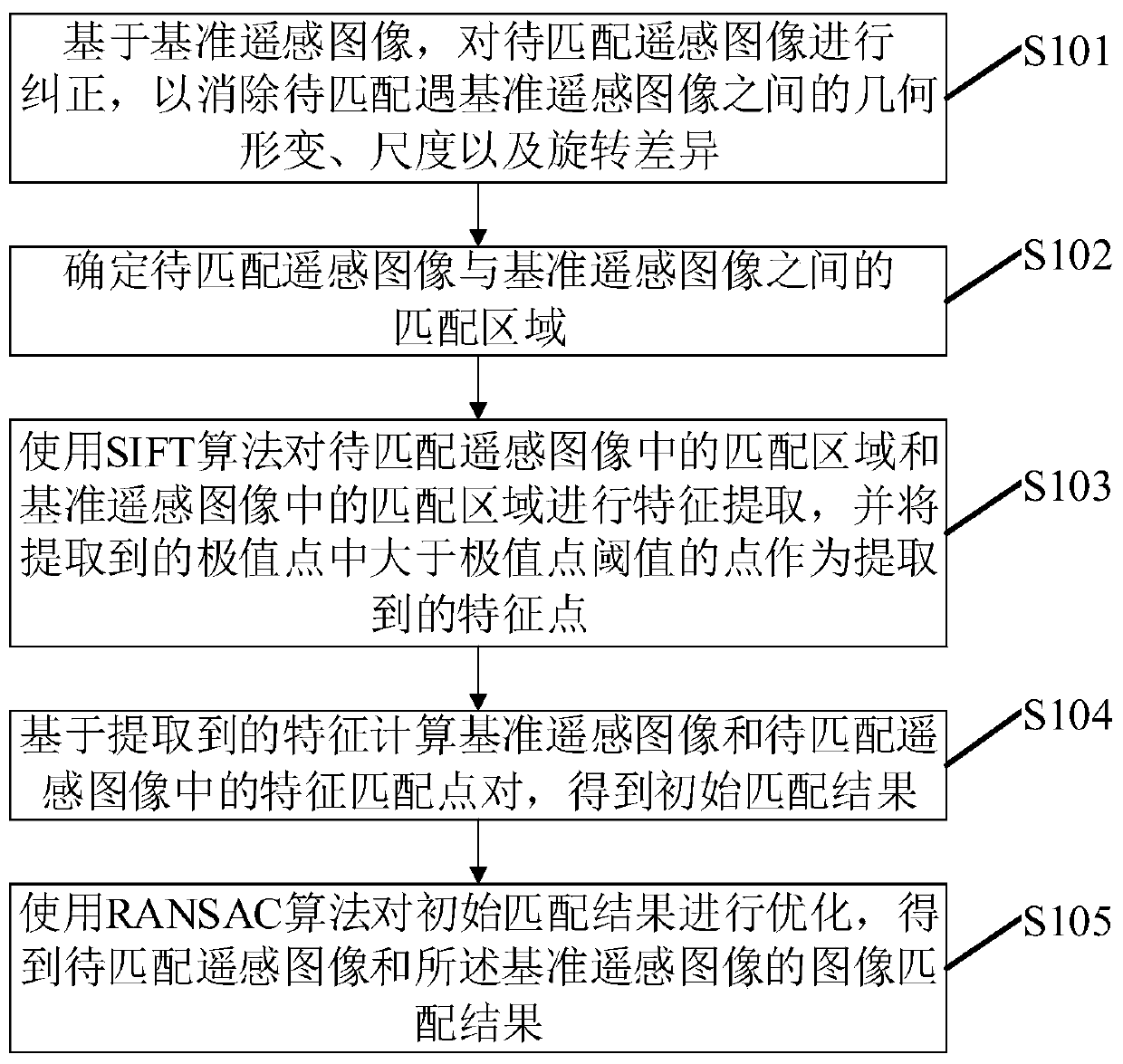
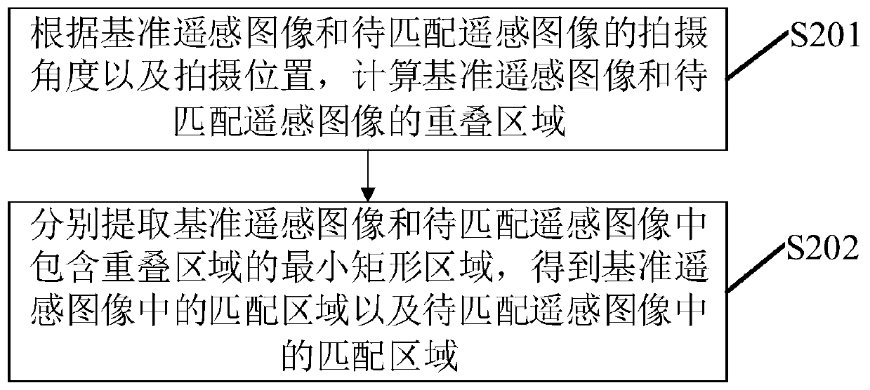
[0028] figure 1 A flowchart showing a remote sensing image matching optimization method according to an embodiment of the present invention, such as figure 1 As shown, the method may include the following steps:

[0029] S101: Correct the remote sensing image to be matched based on the reference remote sensing image, so as to eliminate geometric deformation, scale and rotation differences between the remote sensing image to be matched and the reference remote sensing image.

[0030] In the embodiment of the present invention, the reference remote sensing image refers to the image whose shooting angle is closest to the shooting angle perpendicular to the ground to be shot among two or more images to be matched.

[0031] In the embodiment of the present invention, the remote sensing image can be a remote sensing image taken by a low-altitude aircraft such as a UAV. Correspondingly, the remote sensing image to be matched can be processed based on the reference remote sensing image...

Embodiment 2

[0065] Figure 5 A functional block diagram of a remote sensing image matching optimization device according to an embodiment of the present invention is shown, and the device can be used to implement the remote sensing image matching optimization method described in Embodiment 1 or any optional implementation thereof. Such as Figure 5 As shown, the device includes: an image correction module 10 , an area determination module 20 , a feature extraction module 30 and an image matching module 40 . in,

[0066] The image correction module 10 is used to correct the remote sensing image to be matched based on the reference remote sensing image, so as to eliminate the geometric deformation, scale and rotation differences between the remote sensing image to be matched and the reference remote sensing image.

[0067] The area determination module 20 is used to determine the matching area between the remote sensing image to be matched and the reference remote sensing image. In the e...

Embodiment 3

[0073] An embodiment of the present invention provides an electronic device, such as Figure 6 As shown, the electronic device may include a processor 61 and a memory 62, wherein the processor 61 and the memory 62 may be connected via a bus or in other ways, Figure 6 Take connection via bus as an example.

[0074] The processor 61 may be a central processing unit (Central Processing Unit, CPU). Processor 61 can also be other general processors, digital signal processor (Digital Signal Processor, DSP), application specific integrated circuit (Application Specific Integrated Circuit, ASIC), field programmable gate array (Field-Programmable Gate Array, FPGA) or Other chips such as programmable logic devices, discrete gate or transistor logic devices, discrete hardware components, or combinations of the above-mentioned types of chips.

[0075] The memory 62, as a non-transitory computer-readable storage medium, can be used to store non-transitory software programs, non-transito...


PUM


Abstract

The invention discloses a remote sensing image matching optimization method, device, electronic equipment and storage medium. The method includes: based on a reference remote sensing image, correcting the remote sensing image to be matched so as to eliminate the geometrical gap between the remote sensing image to be matched and the reference remote sensing image. Deformation, scale, and rotation differences; determine the matching area between the remote sensing image to be matched and the reference remote sensing image; use the SIFT algorithm to extract features from the matching area in the remote sensing image to be matched and the matching area in the reference remote sensing image, and extract the extracted Points greater than the extreme point threshold in the extreme points are taken as the extracted feature points; based on the extracted features, the feature matching point pairs in the reference remote sensing image and the remote sensing image to be matched are calculated to obtain the initial matching result; the initial matching is performed using the RANSAC algorithm The results are optimized, and the image matching results of the remote sensing image to be matched and the reference remote sensing image are obtained. By implementing the method, the matching of remote sensing images taken by low-altitude aircraft can be realized more accurately and with higher efficiency.

Description

technical field [0001] The invention relates to the technical field of multimedia information processing, in particular to a remote sensing image matching optimization method, device, electronic equipment and storage medium. Background technique [0002] In recent years, from UAV remote sensing used in topographic surveying and mapping of the Diaoyu Islands, to disaster remote sensing monitoring and disaster assessment in the Lushan earthquake in Sichuan, to the normal monitoring of national marine resources, low-altitude remote sensing technology has highlighted its role in topographic surveying and mapping, disaster emergency monitoring and disaster situation assessment. Low-altitude remote sensing data processing technology has quickly become a research hotspot due to its advantages and application value in many fields such as assessment and environmental monitoring. Image matching is one of the key technologies of low-altitude remote sensing data processing, and its matc...

Claims


Application Information

Patent Timeline
Patent Type & Authority Patents(China)
IPC IPC(8): G06K9/00G06K9/62G06K9/36G06K9/32
CPCG06V20/13G06V10/243G06V10/247G06V10/20G06F18/22
Inventor 邓练兵邹纪升逯明
Owner ZHUHAI DAHENGQIN TECH DEV CO LTD
Learn More