Mine and solid waste landfill automatic extraction method and device based on remote sensing data

A remote sensing data, automatic extraction technology, applied in character and pattern recognition, instruments, computer parts and other directions, can solve the problems of dependence on extraction accuracy, high labor cost, low efficiency, etc., to reduce labor costs and time costs, improve The effect of work efficiency

Active Publication Date: 2021-06-25
MINISTRY OF ECOLOGY & ENVIRONMENT CENT FOR SATELLITE APPL ON ECOLOGY ENVIRONMENT
View PDF8 Cites 5 Cited by
  • Summary
  • Abstract
  • Description
  • Claims
  • Application Information

AI Technical Summary

Problems solved by technology

The ground survey method is costly and inefficient, and some illegal mines and landfills have not been registered, coupled with traffic, geographical and other constraints, making the investigation work extremely difficult
Remote sensing survey methods are mainly divided into artificial visual interpretation and machine learning extraction. Among them, although the artificial visual interpretation method can extract ground object information more accurately, it has a large workload and low efficiency, and the extraction accuracy depends on the solution. According to the experience of translators, machine learning extraction requires a large number of samples for training, and the labor cost is relatively high. Both methods are difficult to meet the needs of daily supervision and emergency response

Method used


Image

  • Mine and solid waste landfill automatic extraction method and device based on remote sensing data
  • Mine and solid waste landfill automatic extraction method and device based on remote sensing data
  • Mine and solid waste landfill automatic extraction method and device based on remote sensing data

Examples


Embodiment 1

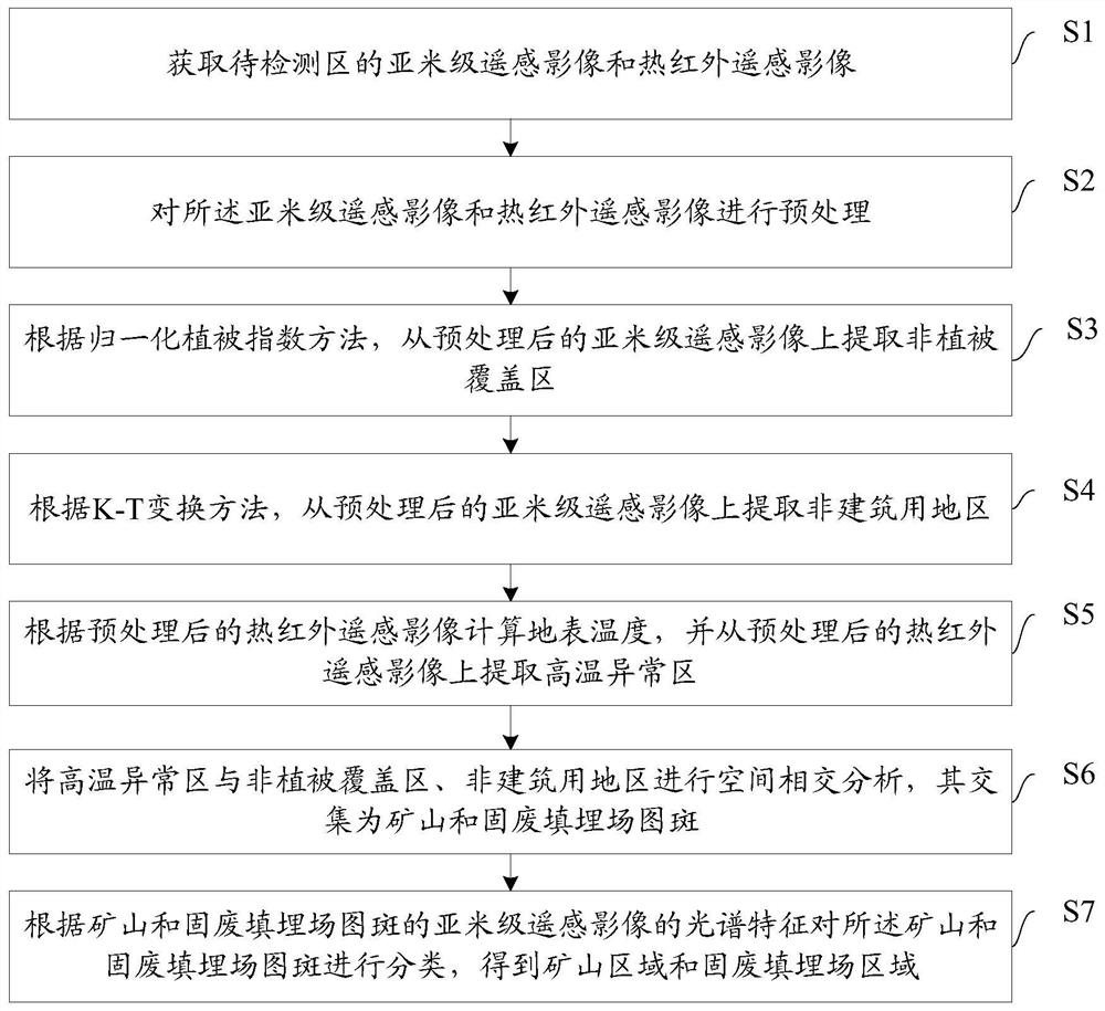
[0085] Embodiments of the present invention provide a method for automatically extracting mines and solid waste landfills based on remote sensing data, such as figure 1 As shown, the method includes:

[0086] S1: Acquire sub-meter remote sensing images and thermal infrared remote sensing images of the area to be detected.

[0087] This step is used for basic data preparation to obtain multi-source satellite remote sensing images of the area to be detected. Multi-source satellite remote sensing images mainly include sub-meter remote sensing images and thermal infrared remote sensing images.

[0088] S2: Preprocessing sub-meter remote sensing images and thermal infrared remote sensing images.

[0089] Preprocessing includes:

[0090] S21: Perform orthorectification, radiation correction and atmospheric correction on sub-meter remote sensing images and thermal infrared remote sensing images.

[0091] Orthorectification: During remote sensing imaging, due to the influence of fa...

Embodiment 2

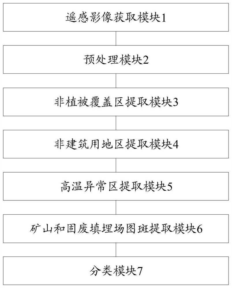
[0137] Embodiments of the present invention provide a remote sensing data-based automatic extraction device for mines and solid waste landfills, such as figure 2 As shown, the device includes:

[0138] The remote sensing image acquisition module 1 is used to acquire sub-meter remote sensing images and thermal infrared remote sensing images of the area to be detected.

[0139] The preprocessing module 2 is used for preprocessing sub-meter remote sensing images and thermal infrared remote sensing images.

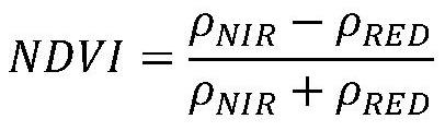
[0140] The non-vegetation coverage area extraction module 3 is used to extract the non-vegetation coverage area from the preprocessed sub-meter remote sensing image according to the normalized difference vegetation index method.

[0141] The non-building area extraction module 4 is used to extract the non-building area from the preprocessed sub-meter remote sensing image according to the K-T transformation method.

[0142] The high temperature anomaly area extraction module...


PUM


Abstract

The invention discloses a mine and solid waste landfill automatic extraction method and device based on remote sensing data, and belongs to the field of environment monitoring. The method comprises the following steps: acquiring a sub-meter remote sensing image and a thermal infrared remote sensing image, calculating a normalized vegetation index and a specific value building index by using the sub-meter remote sensing image, and extracting a non-vegetation coverage area and a non-building area; inversing the surface temperature by using the thermal infrared remote sensing image, fitting a normal distribution curve based on a surface temperature value, and extracting a high-temperature abnormal region; based on the high-temperature abnormal area extraction result, removing vegetation coverage areas and building areas, and obtaining pattern spot information of mines and solid waste landfills; and establishing a classification model, carrying out secondary classification on the information of the mine and the solid waste landfill, and obtaining the mine and the solid waste landfill through grid vectorization processing. According to the invention, automatic extraction of the mine and the solid waste landfill is realized, the labor cost and the time cost are greatly reduced, the working efficiency is improved, and technical support is provided for environmental pollution source supervision.

Description

technical field [0001] The invention relates to the field of environmental monitoring, in particular to a method and device for automatically extracting mines and solid waste landfills based on remote sensing data. Background technique [0002] my country is a country rich in mineral resources, and rich mineral resources are one of the main factors that promote the automatic development of my country's economy, but at the same time, large-scale development has also caused a large number of ecological and environmental problems. Remote sensing monitoring data show that by the end of 2018, my country's mines occupied and damaged more than 54 million mu of land, and historical mines occupied and damaged more than 34 million mu. The destruction of mountains and vegetation caused by mining is often the main factor that induces landslides, mountain torrents and other disasters and subsidence accidents. Therefore, in order to thoroughly implement the idea of ​​ecological civilizat...

Claims


Application Information

Patent Timeline
IPC IPC(8): G06K9/00G06K9/20G06K9/62
CPCG06V20/176G06V10/143G06F18/2134G06F18/24
Inventor 余嘉琦李营刘玉平饶瑞璇殷守敬王晨陈辉王雪蕾肖如林贾兴靳川平孙浩徐丹滕佳华
Owner MINISTRY OF ECOLOGY & ENVIRONMENT CENT FOR SATELLITE APPL ON ECOLOGY ENVIRONMENT
Why Eureka
Try Eureka