Unmanned aerial vehicle path planning method for minimizing number of unmanned aerial vehicles

A path planning and UAV technology, applied in the field of communication, can solve the problem of not considering the distance between the sensor node and the starting position of the UAV, and achieve the effect of expanding diversity, reducing total energy consumption, and expanding solution space

Active Publication Date: 2021-08-31
XIDIAN UNIV
View PDF9 Cites 2 Cited by
  • Summary
  • Abstract
  • Description
  • Claims
  • Application Information

AI Technical Summary

Problems solved by technology

In this scheme, the node closest to the current sensor node is selected as the next node to be visited by the UAV every time, without considering the distance between the sensor node and the starting position of the UAV, and according to the UAV itself The optimal sensor node access method plans the path, which cannot avoid the impact on other drones, so the number of drones used is not necessarily the minimum

Method used


Image

  • Unmanned aerial vehicle path planning method for minimizing number of unmanned aerial vehicles
  • Unmanned aerial vehicle path planning method for minimizing number of unmanned aerial vehicles
  • Unmanned aerial vehicle path planning method for minimizing number of unmanned aerial vehicles

Examples


Embodiment Construction

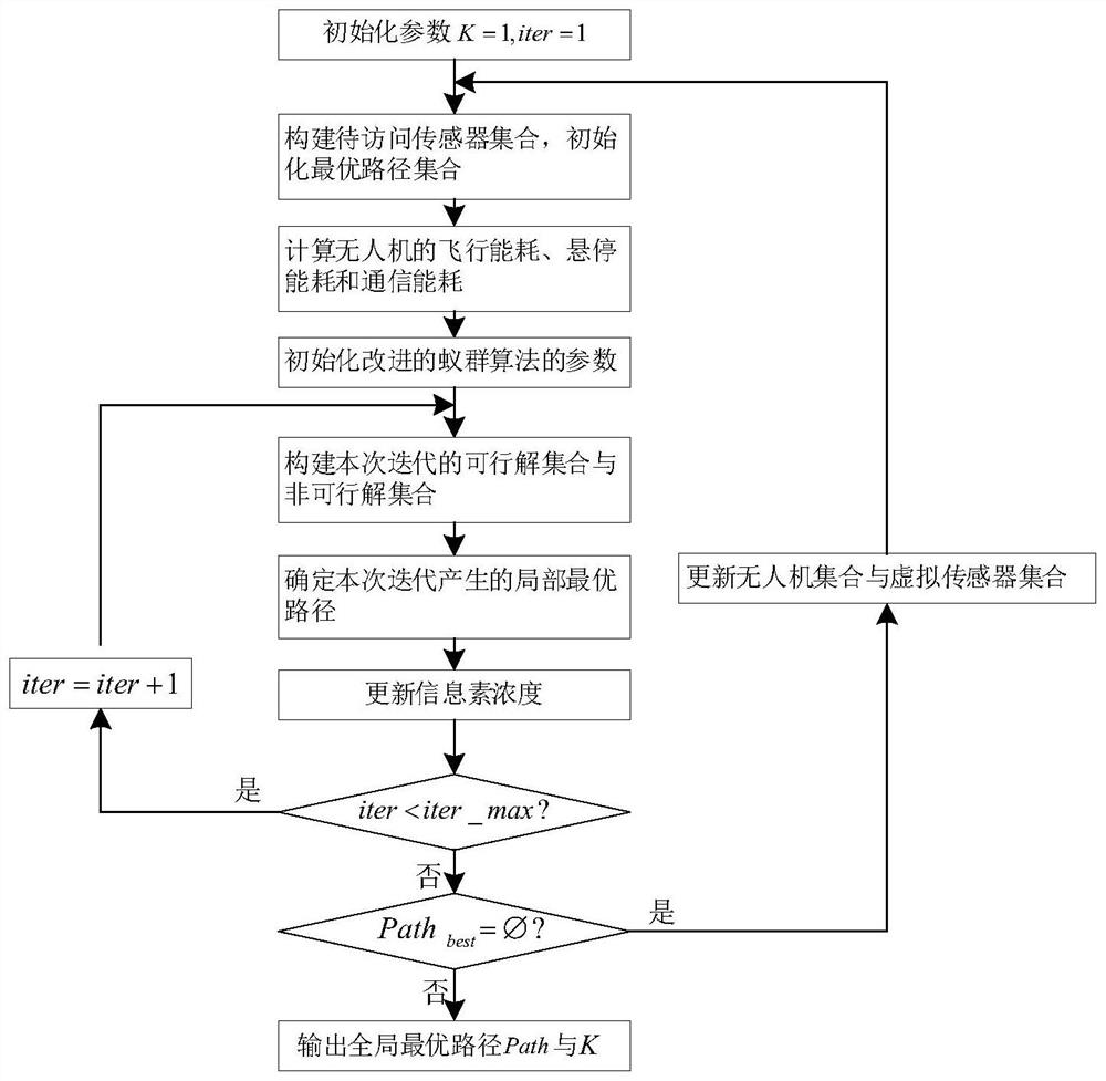
[0049] The present invention will be further described in detail below in conjunction with the accompanying drawings and specific embodiments.

[0050] refer to figure 1 , the present invention comprises the following steps:

[0051] Step 1, initialize parameters:

[0052] (1a) Initially distributed on the ground, the coordinate position is (0,0) and the central controller is O. There are K drones U={U 1 ,U 2 ,...,U k ,...,U K}; Initialize I sensors distributed on the ground as A={A 1 ,A 2 ...A i ,...A I}, I≥2, the i-th sensor A i The location coordinates are (x i ,y i ); the maximum energy of all drones is E th , the flight speed is v, and the flight energy consumption, hovering energy consumption and communication energy consumption per unit time are e f 、e h and e t , at the i-th sensor A i The time for hovering and communicating in the sky is K ≥ 1, in order to avoid wasting drone resources, the number of drones in the network should not exceed the number...


PUM


Abstract

The invention provides an unmanned aerial vehicle path planning method for minimizing the number of unmanned aerial vehicles, which mainly solves the problem of minimizing the number of unmanned aerial vehicles in the existing unmanned aerial vehicle path planning scheme, and comprises the following implementation steps: 1) initializing parameters; 2) constructing a to-be-accessed sensor set and initializing a local optimal path set; 3) calculating flight energy consumption, hovering energy consumption and communication energy consumption of the unmanned aerial vehicle; 4) planning flight paths for a given number of unmanned aerial vehicles by adopting an improved ant colony algorithm, and determining a local optimal path set; and 5) obtaining an unmanned aerial vehicle path planning result according to the characteristics of the local optimal path set. According to the invention, on the basis of accessing all the sensors, the minimum number of unmanned aerial vehicles are used to complete the task, the system cost is reduced, and the total energy consumption of the unmanned aerial vehicles is reduced.

Description

technical field [0001] The invention belongs to the field of communication technology, and relates to a UAV path planning method, in particular to a UAV path planning method for realizing the minimization of the number of UAVs, which can be used for data collection under the condition that the cost of UAVs is limited. Background technique [0002] In recent years, UAV technology has developed rapidly and plays an important role in military and civilian fields. The lightweight body and flexible movement mode enable the UAV to collect and transmit data in complex environments. In practical applications, whether it is a fuel-based UAV or a rechargeable UAV, the energy is limited, and the economic cost of purchasing a UAV cannot be ignored. The price of a civilian UAV can reach When using multiple drones to access sensor nodes, the more drones used, the greater the total cost of accessing sensor nodes. Therefore, in the UAV network, it is necessary to determine the minimum num...

Claims


Application Information

Patent Timeline
Patent Type & Authority Applications(China)
IPC IPC(8): G05D1/10
CPCG05D1/101Y02D30/70
Inventor 赵林靖霍小露张岗山马建鹏李钊刘勤
Owner XIDIAN UNIV
Why Eureka
Try Eureka